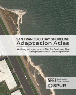
As the climate continues to change, communities will need to adapt the San Francisco Bay shoreline to rising sea levels. But the Bay’s varied landscapes and overlapping jurisdictions make a coordinated response challenging. The San Francisco Bay Shoreline Adaptation Atlas proposes a new regional planning framework by dividing the 400-mile Bay shoreline into 30 distinct geographic areas that share common physical characteristics and adaptation strategies.
The 10-year census is a profound expression of who our nation is and who deserves to be included in our political systems and public services. With the 2020 census less than a year away, SPUR is hosting a series of events to look at ongoing local strategies to make sure everyone in the Bay Area gets counted.
In cities and regions across Germany, dozens of transit operators work together to provide riders with one simple and convenient transit system that is competitive with driving for many trips. It’s a far cry from the Bay Area, where transit services all have separate fares, schedules and maps. How were Germany’s cities able to align multiple operators into one seamless system?
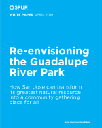
From New York City’s High Line to Atlanta’s BeltLine, communities across the country are transforming underutilized infrastructure into engaging public spaces. Building on this national momentum, SPUR has launched a project to reconsider the Guadalupe River Park, an underappreciated gem in downtown San Jose.
In recent weeks the Oakland Department of Transportation has begun publicizing its new $100 million, three-year paving plan. Ordinarily a plan that triples annual spending would meet with universal acclaim. But this plan — which incorporates equity in deciding how to spend money on paving streets — has some parts of town happy and other parts up in arms.