There’s a lot to celebrate in the world of climate action and sea level rise adaptation in the Bay Area. The Bay Conservation and Development Commission adopted the Regional Shoreline Adaptation Plan in December 2024, voters approved California’s $10 billion climate bond (Proposition 4) in November 2024, and the Port of San Francisco released its Waterfront Flood Study in January 2024. To continue riding this positive wave, amid federal government hostility to climate science, SPUR launched Watermarks: Postcards from the Future, an interactive exhibition on sea level rise and flood adaptation in the Bay Area.
The exhibition drew more than 100 people to its opening night, April 10, just ahead of SF Climate Week. In collaboration with Gabriel Tenaya Kaprelian, assistant professor in the College of Architecture and Environmental Design at Cal Poly, SPUR invited visitors to explore the exhibition––imagining the city’s evolving shoreline through hands-on climate games, an augmented-reality walking tour, interactive maps of San Francisco’s shoreline (past, present, and future), and a front-window display showcasing San Francisco Bay’s tidal ecology threatened by sea level rise. Watermarks was made possible by Exygy, a technology B Corp known for its design of the Cal Fire platform, which sponsored the exhibition to help bring awareness to the compound flood risks facing the Bay Area and to speak to the role of digital tools and design in building climate-ready infrastructure.
As part of the exhibition, SPUR partnered with the Port of San Francisco to highlight its Waterfront Resilience Program and spotlighted flood-resilient design projects from SPUR business members, including CMG Landscape Architecture, SWA Group, Gensler, Page & Turnbull, Mithun, David Baker Architects, and the San Francisco Estuary Institute, a long-time SPUR collaborator.
Reframing the Climate Change/Sea Level Rise Narrative
Watermarks asked Bay Area residents to continue reimagining their relationship with water in the face of extreme storms and rising seas. Those phenomena can awaken feelings of fear and uncertainty, but the exhibition advanced a narrative of collaboration, creativity, and opportunity –– critical drivers for efforts to meet climate change challenges.
Climate change and sea level rise conversations often begin with loss — of ecosystems, infrastructure, and human communities. While this loss is very real and is accelerating, Watermarks invited participants to approach this moment from a different starting point:
- What if we look to the past to help inform future possibilities for the waterfront and reframe our relationship with water as one of coexistence rather than control?
- What if adaptation projects could both revive natural ecosystems, like curried marshlands, and improve public access to the waterfront?
- What if adaptation needs also create space for community empowerment and equitable action?
Through thoughtful design, inclusive storytelling, and cross-sector collaboration, the project set out to create a more hopeful and equitable path toward a resilient future. Watermarks highlighted two projects that are helping realize this path.
Nature-based Adaptations and Beach Access for North Richmond
Mithun worked with the West Council Wastewater District, the San Francisco Bay Restoration Authority, the Watershed Project, and other organizations to root the North Richmond Living Levee and Collaborative Adaptation Shoreline Plan in the self-determination of a community vulnerable to sea level rise. The North Richmond community, which is downwind from a refinery and near other polluting industries, has already endured decades of environmental injustices. A newer challenge is flooding. To support residents’ pursuit of a resilient future, the project team established community working groups that met weekly over six months to collaborate on designs for the North Richmond shoreline, including improved pedestrian access and nature-based adaptations for sea level rise.
A Low-Carbon-Input Park for Alameda Point
De-Pave Park, a project proposed by CMG Landscape Architecture for the City of Alameda, aims to transform a 21-acre section of Alameda Point, a decommissioned military base, into a thriving intertidal marsh and community space. The park could become a model for mitigating the effects of climate change by sequestering far more carbon than is emitted to build and maintain it. The park’s creators hope to offset the park’s carbon footprint in just four years by repurposing existing concrete pavement rather than installing new materials.
Watermarks and the Power of Partnerships
The Alameda Point and North Richmond projects are exactly the kind of bold and multi-benefit projects that Bay Area cities need. Both bring ecological and social benefits to underutilized waterfronts while engaging residents and addressing historical environmental injustices. And both began with collaborative imagining of what’s possible.
To inspire new visions of climate resilience, SPUR convened a series of events, including the opening night of Watermarks, which drew more than 125 attendees.
- Using the Circular Economy to Reimagine Our Coastal Cities, a panel hosted in partnership with the Netherlands Consulate in San Francisco, explored how circular economy principles can help Bay Area cities reimagine coastal infrastructure, adapt to sea level rise, and create sustainable, people-centered public spaces. Panelists included representatives from Arcadis, Gensler, CMG Landscape Architecture, and the SF Environment Department.
- “Living With Water” Trivia Night, hosted with Arcadis, challenged trivia teams to compete for prizes while learning about international flood management projects, local Bay Area water management and development history, and potential future sea level rise impacts.
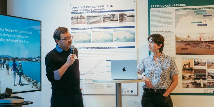
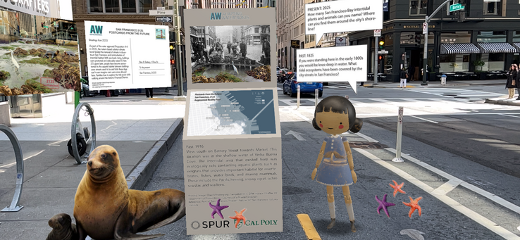
- Augmented-Reality Waterfront Walking Tour, an immersive walking tour created by Assistant Professor Gabriel Kaprielian and co-hosted by the Port of San Francisco, explored San Francisco’s waterfront past, present, and future. Participants reimagined climate adaptation while learning about San Francisco’s historic waterfront and ways that the past can inform future innovations. To close the walking tour, Luiz Barata from the Port of San Francisco described the Waterfront Resilience Program and projects the port is undertaking to protect downtown San Francisco and the Embarcadero from sea level rise and earthquakes. SPUR’s self-guided, augmented-reality waterfront walking tour is available here.
SPUR has long engaged in visioning exercises aimed at turning challenges into opportunities and just as often has offered concrete plans to implement their results. Climate change has inspired some of those exercises, including the Ocean Beach Master Plan and the Mission Creek Sea Level Rise Adaptation Study, which have involved partners from climate tech to design and engineering firms to government agencies to local and international organizations.