
Apr
10
2025
May
9
2025
San Francisco
Imagine a postcard sent from San Francisco 100 years in the future. What might someone write back and what images would they send to describe how the city has responded to a changing climate in the 22nd century?
Watermarks, a new exhibition at SPUR, is an interactive exhibition that invites visitors to explore the past, present, and potential future transformations of the city’s changing shoreline. Through imaginative installations, an augmented reality tour, climate games, flood-resilient design strategies, and exhibits of the large-scale efforts currently underway by City agencies to address the climate crisis, attendees will gain a deeper understanding of the impacts of extreme storms and flooding and the opportunities for rethinking our relationship with water. The Watermarks exhibition and related events seek to inspire collective optimism and empower informed action by reframing the challenges of sea-level rise as an opportunity for innovative thinking.

Visitors will leave not just with knowledge, but with resilient strategies that they can take to shape the future of the waterfront. While climate change can feel perpetually like a future problem, through the exchange of knowledge that fosters creative discourse today, we can envision new opportunities for living with water while considering our place in the changing world. Step inside, see what’s happening now, and discover how you can be part of the solution.
Curated by:
Sarah Atkinson, Hazard Resilience Sr. Policy Manager at SPUR
Gabriel Tenaya Kaprielian, Assistant Professor in the College of Architecture and Environmental Design at Cal Poly. Director of Design and Innovation for Sustainable Cities (DISC) in the College of Environmental Design at UC Berkeley
With partners: Port of San Francisco, San Francisco Public Utilities Commission, and more
Explore Postcards from the Future, an Augmented Reality SF Walking Tour
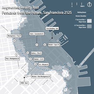
Postcards from the Future, San Francisco 2125 is a guided augmented reality tour along the historic shoreline, beginning at SPUR and ending at the Ferry Building. The project invites the public to explore the past, present, and potential future transformations of the city’s shoreline by visualizing place-based changes at 8 designated locations. While many coastal cities are planning for a projected sea-level rise of 3-7 feet by 2100, high projection models show a potential 16 feet rise by 2150. As it is unknown how fast the ice sheets will melt, combined with the additional effects of increased flooding due to more extreme weather events, tidal cities around the world will need to plan for uncertainty.
To take the self-guided tour, please review the AR tour packet (link here) and download Adobe Aero on your smartphone. Or go to the tour website here.
Thank you to our sponsor:

This exhibition is free to the public.