

Photo of Arrowhead Marsh courtesy The Art Project.
Photo of Arrowhead Marsh courtesy The Art Project.
A public–private collaborative effort to help the Bay Area plan for and respond to sea level rise and storm events.
The Adapting to Rising Tides (ART) project pioneered sea level rise planning for a large section of the San Francisco Bay shoreline — creating both actionable strategies to build resilience in Alameda County, its first pilot location, and a model planning process that could be replicated in other parts of the Bay Area.
In 2011, the Bay Conservation and Development Commission (BCDC) in partnership with the NOAA Coastal Services Center launched the ART project in response to growing regional awareness of the existence of — and need to prepare for — sea level rise and storm events. The ART pilot project was established to conduct in-depth studies of local vulnerabilities, and to create replicable, collaborative planning tools to help Bay Area communities and organizations understand risks and develop actionable solutions.
The ART project initially focused on a portion of the Alameda County shoreline, from Emeryville to Union City, where there are regionally significant assets like the Bay Bridge, Oakland International Airport and the Port of Oakland, along with features common to the entire Bay Area shoreline, including residential neighborhoods, energy and water infrastructure and parks. The project team evaluated a number of assets in the study area, identified stressors, considered the impacts of 16 inches and 55 inches of sea level rise, along with storm effects, and surveyed stakeholders to evaluate the sensitivity and adaptive capacity (ability to adjust/accommodate change) of the assets. Finally, the ART team developed hundreds of possible adaptation responses to observed vulnerabilities and identified which types of entities in the subregion could implement the various actions — ranging from data collection to education — to improve the resilience of neighborhoods.
As a result, there are now “road-tested” adaptation planning processes and tools as well as a broad suite of subregional vulnerabilities and adaptation responses, the majority of which are meaningful to all areas of the bay shoreline, that are being used to jump-start adaptation efforts in other locations.
With the threat of sea level rise looming, major wetland restoration projects aim to build ecological resilience and buffer the impacts of storms on the shoreline
Large swaths of bay wetlands are being restored and managed in an innovative way that continuously monitors and adapts to climate change, while permanent funding for more of these efforts may be on the way through the work of a new regional agency dedicated to finding local funding for restoration.
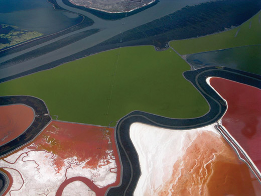
With the largest estuary on the west coast, the San Francisco Bay is home to 500 species of wildlife including millions of migratory birds, and an economic engine that directly generates millions of dollars and jobs in the tourism, shipping and fishing industries. Once home to over 200,000 acres of tidal wetlands, the bay has only about 45,000 acres of healthy wetlands today — a number that actually reflects significant progress in wetland protection and restoration over the last 20 years. These bay wetlands account for more than 90 percent of California’s remaining tidal wetlands, and provide local benefits such as flood protection, improving water quality, sequestering carbon, and providing critical habitat for birds and fish. But bay wetlands are threatened by rising sea levels. Without room for wetlands to migrate landward as sea levels rise, they will become submerged.
The South Bay Salt Pond Restoration Project — the largest wetland restoration project on the west coast — is actively restoring over 15,000 acres of former industrial salt ponds to tidal activity and managed ponds. Acquired by the federal and state government from Cargill in 2003, the project is managed by a partnership of federal and state agencies, flood control districts, and park districts for three key purposes: restoring wetland habitats, providing flood control, and enabling public access and recreation. The project uses an adaptive management framework to measure and observe changes on the ground and feed that information back into land management decisions. This framework enables the project to prepare for climate change along with other uncertainties, including changing habitats, water quality, invasive species and the impact of public access on wildlife. The project has already opened miles of new public trails in three project areas — Eden Landing, Ravenswood and Alviso — and restored over 3,000 acres to tidal function.
A mix of federal, state and private funding from such entities as the U.S. Fish and Wildlife Service, the U.S. Army Corps of Engineers, NOAA, the State Coastal Conservancy, the Wildlife Conservation Board, and the Hewlett, Packard and Moore foundations, has made these projects possible, funding the acquisition, planning, and the first phases of restoration. However, the future of funding for ongoing planning and restoration work — ranging from permitting to moving dirt to assessing and monitoring tidal flows — is not secure. Thousands of acres of publicly owned former tidal areas could be restored today if funding were available. To address this, Save the Bay, SF Bay Joint Venture and other groups sought to create a regional agency with the authority to raise revenue from local sources, resulting in the enactment of the Bay Restoration Authority in 2008 (AB 2954). The Authority is likely to place a regional revenue measure on the ballot in November 2014 in all nine Bay Area counties, to be used for habitat improvements, safer public access and restoration work.
Two sea level rise planning projects, one on each side of San Francisco, containing adaptive strategies that provide both flood control and a better public realm.
The Ocean Beach Master Plan includes several innovative ideas to improve habitat, recreation and circulation and to protect key infrastructure at the beach — and it is a model for integrating sustainable urban design into sea level rise planning.
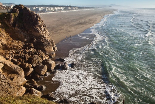
Photo of Ocean Beach by David Lloyd for AECOM
In San Francisco, SPUR is helping to lead two sea level rise planning projects, one of which — the Ocean Beach Master Plan — is moving toward implementation; the other—Mission Creek — is just getting started.
At Ocean Beach, SPUR is conducting three implementation studies to follow up on the success of the Ocean Beach Master Plan (April 2012), a long-term vision for the beach supported by state bond funding from the Coastal Conservancy. That plan, a nonregulatory vision and set of policy recommendations, unified federal, state, local agencies, stakeholder organizations and beach users around six key moves that could help the beach better withstand future sea level rise and erosion. These moves are strategies designed to protect transportation and wastewater infrastructure embedded at the beach, while supporting ecological health, public access and recreational improvements. (For example, one key move is to restore dunes through beach nourishment in the middle reach of the beach, installing sand ladders and boardwalks for pedestrian access.)
The three Ocean Beach implementation studies underway are a coastal management framework, a transportation study, and an open space planning study. The transportation study, which kicked off in the summer of 2013, will collect traffic data and analyze recommendations in the Master Plan — rerouting and narrowing the Great Highway, extending the Muni light rail line and more. The coastal management framework will identify interim protection strategies for the Master Plan’s coastal recommendations and key moves. The open space study will look for opportunities to improve coastal access and connections among important open space resources near the beach including Golden Gate Park, Fort Funston and Lake Merced.
On the eastern waterfront of San Francisco, Mission Creek is one of the city’s lowest-lying areas and is vulnerable to flooding from both sea level rise and stormwater runoff. In early 2014, SPUR launched a project with the Port of San Francisco, the SF Public Utilities Commission, other city agencies, BCDC and the Delta Alliance (of the Netherlands) to consider vulnerabilities and potential adaptation strategies for this area. The first step in this project is creating an inventory of shoreline protection features, as well as assets of interest (transportation, infrastructural, community-based) using processes developed both by BCDC in the Adapting to Rising Tides (ART) project in Alameda County, and by the Netherlands. Eventually, the project will propose adaptation alternatives that measures, as well as governance and financing strategies.
A trio of visionary planning documents for the region’s ecosystems that lay out management recommendations for every type of habitat, from the bottom of the bay to the hilltops of the greenbelt.
The Habitat Goals projects utilize the best-available science and unify the conservation community around prioritizing certain places and ecosystems for protection.

Photo of North Bay hills by Jon ‘ShakataGaNai’ Davis
The first of three habit goals projects, the Baylands Ecosystem Habitat Goals Project, which was completed in 1999 after a four-year process involving over 100 scientists and ecosystem managers, identified what kinds and amounts of wetland habitats around the bay should be restored to sustain diverse wildlife. The project identified the extent of historic wetlands, the quantity that has been diked or filled, the area open to tidal action, and the habitat needs of key wildlife species in the region. The Goals then made subregional, long-term recommendations for habitat changes, establishing one memorable goal that has driven ecosystem managers for over a decade: 100,000 acres of tidal marsh was the right quantity needed to restore the health of the bay. Ideally, the mix will include large patches of tidal marsh connected by corridors, extensive areas of managed seasonal ponds, restored beaches, and vegetated areas along the bay’s tributary streams.
In order to take sea level rise and climate change impacts into account, the Bay Area Ecosystems Climate Change Consortium, with funding from the Coastal Conservancy, launched a 2012 effort to update the Habitat Goals Project to reflect how sea level rise will affect bayland habitats, how managers should respond, and how the goals might change. A climate change update to the goals should be available later in 2014.
The second project, the Bay Subtidal Habitat Goals Project (2010), created a compendium of ecosystem types for the submerged area of the bay, from the seafloor of mud, sand and rocks to shallow shellfish and eelgrass beds. These ecosystems, while hidden from view, support the health of the bay by providing food and habitat for salmon, herring, crab and shellfish, marine mammals, and shorebirds. Some of the strategies in the Goals report include increasing native oyster populations and removing artificial structures from the bay that have limited habitat benefits.
Finally, the Conservation Lands Network (CLN) was completed in 2011. Like the Baylands and Subtidal Goals projects, the CLN convened over 100 scientists and resource experts to identify the types, amounts and distribution of habitats in the nine-county Bay Area necessary to sustain regional biodiversity. Its recommendations include protection of working lands, adaptive management practices, restoring streams channels and focusing development away from essential habitats. The project also created a publicly accessible mapping tool to track conservation targets, protected lands and climate changes on any land parcel and over time, so that conservation goals may be dynamically updated.
A creek that has repeatedly flooded for years has a new management strategy, designed to improve habitat while protecting neighbors from both fluvial flooding and sea level rise.
A program of watershed-based planning and flood protection means that neighboring property owners will no longer need to buy flood insurance.
Looking north at high tide, with the Creek in the foreground. Photo by Len Materman
The San Francisquito Creek watershed covers 50 square miles, from Skyline to the bay, encompassing parts of San Mateo and Santa Clara Counties, and the cities of Menlo Park, Palo Alto, and East Palo Alto. The creek itself wends through highly developed, suburban floodplains, underneath two interstates, and ends in the baylands just beyond an angular, engineered channel bordering a golf course and the Palo Alto Airport. Viewed as a liability, perhaps even a nuisance, for many years, the creek would occasionally flood in two directions — causing disruption to significant numbers of homes. In 1998, 1,700 properties sustained $28 million in flood-related damages. The cities and counties realized that neither side could solve the problem alone, and governance stood in the way of effective solutions. The year after the flood, San Francisquito Creek Joint Powers Authority (JPA), a partnership of the cities of East Palo Alto, Palo Alto, Menlo Park, the San Mateo County Flood Control District, and the Santa Clara Valley Water District, was formed to create a forum for agencies to solve problems of mutual interest at the watershed scale.
The JPA developed a watershed plan, considering both river and tidal floodplains, and the potential impact of climate change, and created strategies to eliminate flood risk. The plan’s first major capital project is a creek widening project that will substantially enlarge the creek’s tidal marsh floodplain by creating over 15 acres of new marsh lands, and construct new levees and floodwalls where homes and businesses are adjacent to the channel. The project is designed to enable the creek to withstand a 100-year storm, coupled with an extreme high tide and 26 inches of sea level rise. Other projects in the works to improve flood protection include a replacement bridge for Highway 101 over the creek, which will be designed to help expand flow capacity, and other bridge replacements and channel widening further upstream.
A benefit — and an overall objective — of this project is to remove some currently impacted properties from FEMA flood risk maps and to enable property owners to avoid paying premiums to the National Flood Insurance Program. Because about 40 percent of properties in the creek’s 100-year floodplain are also in the bay’s 100-year floodplain, the JPA work will provide tidal and sea level rise protection to East Palo Alto and Menlo Park as a whole. The project’s accounting for sea level rise goes above and beyond any FEMA requirements, helping to eliminate this risk and protect nearby property owners for many decades to come.
A new facility designed to highly purify wastewater to drinking water quality, putting it to better use while reducing pollution in the bay.
The water purification plant demonstrates technologies that allow wastewater to be treated and reused for drinking, providing a reliable, climate-proof supply of water at well below the cost of desalinating sea water.
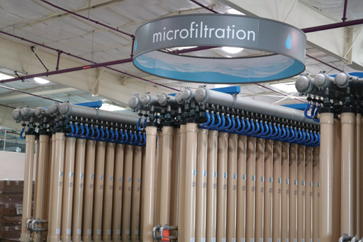
Photo of SVAWPC courtesy Santa Clara Valley Water District
The Bay Area is vulnerable to impacts of climate change other than sea level rise. More than twothirds of the region’s water is imported from sources outside the region that are vulnerable to drought, earthquakes and new regulations on availability — risks that will only intensify with future climate change. Meanwhile, our region will add 2 million people by 2040, increasing demand for available water.
Of the many tools for reducing water demand and increasing water supply that we evaluated in our 2013 report, Future-Proof Water, nearly all are best practices with a long track record of success in California. One that’s more on the cutting edge has just been built in Santa Clara County. The new Silicon Valley Advanced Water Purification Center (SVAWPC) is a partnership between the Santa Clara Valley Water District and the City of San Jose that takes treated wastewater from the city’s wastewater plant and highly purifies it to match drinking water quality standards. The purified water will be blended with existing nonpotable recycled water supplies to improve its quality and expand its usage. These uses include, for now, largescale irrigation and industrial cooling. The plant will also serve as a pilot facility for studying potable reuse of wastewater, through testing its capabilities to remove chemicals of emerging concern, such as pharmaceuticals.
While the state has yet to approve “direct potable reuse” of treated wastewater, the state Department of Public Health and the Water Resources Control Board are conducting a feasibility study to develop uniform water recycling standards that would permit direct potable reuse by 2016.
The real challenge for direct potable reuse is not technological, but psychological. In the United States, people are not accustomed to the idea of drinking purified former wastewater, despite the fact that millions of people already do, albeit in an unplanned way. Facilities like the new SVAWPC will help build public support for, and demystify the idea of reuse. That support will be invaluable as the Bay Area grows and needs to adapt to the uncertain water future of our changing climate.