
Downtowns are arguably the greatest achievement of American urbanism. No other society has concentrated so much of the city's commercial activity—both business and retail—in a tight urban core. And because of typical American residential patterns, downtown high-rises and transit use stand out in stark contrast to the sprawling pattern of settlement that marks so much of American life.
Among the many great U.S. downtowns, San Francisco's also stands out. Our compact downtown sits nestled between the hills and San Francisco Bay, with the wide spine of Market Street and its layers of transit framed by a healthy mix of buildings representing each era of growth.
The success of our present-day downtown San Francisco is one part accident: We inherited a beautiful setting and dense urban form in a dynamic and economically successful region. But it's also one part planning: We invested in transit connections such as BART and Muni Metro, and enacted groundbreaking urban plans that focused on the human aspects of making downtown a better place.
The suburbanization threat, growth wars and the Downtown Plan
San Francisco's downtown built off early successes as one of the nation's densest and most transit-reliant downtowns. Yet with the rise of the private automobile in the 1920s and the rapid population growth in the emerging suburbs, downtown San Francisco's future as the region's central business district was threatened. While the city maintained its strong transit connections with the region—the Key System bringing East Bay streetcar riders to waiting ferries and the Southern Pacific rail lines bringing them from the south—other investments meant to reinforce downtown San Francisco further promoted decentralization. The opening of the Bay Bridge in 1936 and the Golden Gate Bridge in 1937 made auto commutes from distant suburbs possible.
In subsequent decades, downtown San Francisco struggled with the twin problems of how to integrate the automobile into the historic downtown and how to compete with the emerging suburban job centers that benefited from all the new investment in highways.
In San Francisco, there was both a civic and governmental response to these threats. Recognizing the competitive threats from the suburbs, SPUR and other organizations led an effort to reassert the importance of downtown within the city and the region. They began arguing that San Francisco's downtown needed to grow and expand its boundaries to accommodate the expected rise in business services. And perhaps most importantly, they advocated for the creation of the Bay Area Rapid Transit system to connect downtown with the region, and the Muni Metro system to move the slower streetcars underground.
At the same time, the public sector worked to shape the precise look and feel of downtown. Through a series of reports and early land-use plans in the 1940s and 1950s, the Planning Department argued that the way to reduce the challenge of decentralization on the historic supremacy of downtown San Francisco was to accommodate more commerce, address downtown parking and traffic through improved public transit, and provide additional open space. In 1957, the dream of a Bay Area subway became much more real when the State Legislature approved the creation of a five-county BART district.
While the tools of redevelopment used in the effort to "modernize" downtown were often suspect, the increasing focus of the time was on humanizing downtown through placemaking, while still reinforcing its role as the center of the city's economy.
The year 1960 saw the first revisions to the city's zoning in 40 years. The rudimentary treatment of downtown had uniform bulk controls ("floor area ratios") for all lots. This was refined through a series of reports, including Mario Ciampi's 1963 downtown study and a 1966 zoning study that proposed lowering heights and FAR. Ultimately, these ideas culminated in the 1971 citywide Urban Design Plan that emphasized "human needs" and preserving the natural form of the city through controlling the location and scale of new development.
Yet, when the 1970s office boom came, the ideas in the Urban Design Plan were too rudimentary to appropriately shape downtown. This boom led as well to a growing movement of opposition to downtown as a high-rise employment center.
Throughout the 1970s, opponents pursued various ballot measures to block new development or limit the height of new buildings. While none of these measures succeeded at the ballot box, the backlash to downtown growth actually created a political and economic climate wherein city planners could demand more of developers. For example, the threat of totally stopping all development resulted in planners being more able to ask for concessions, such as changes to design to accommodate open space or access to transit as well as more money for parks, housing and other public goods.
With growth wars as the backdrop, in 1985 the City adopted the Downtown Plan. The Downtown Plan provided greater specificity for many of the ideas that had been in practice for several decades—bringing light to the street, requiring some open space, sculpting the form of the skyline from a distance, and other principles. In some areas it raised heights and in many more it reduced them. It also focused on how the ideas would be implemented and monitored over time. (See sidebar for more detailed information on the Downtown Plan).
And while the Downtown Plan is considered a great success, it is important to recognize the plan as a compromise that allowed the city to continue to grow and evolve. For some, it was too restrictive, for others too permissive. Still, the concepts within the Downtown Plan continued to shape downtown as it grew.
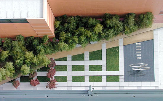
The 1985 Downtown Plan requires new buildings downtown to provide one square foot of open space for every 50 square feet of office space. A product of the regulation, this plaza at 560 Mission Street is an especially popular lunch spot. Image: The Landscape Office
Looking ahead: Further balancing jobs, transit and placemaking
The creation and maintenance of a downtown is difficult work. It requires explicit focus on placemaking, investments in infrastructure, localized land use decisions (and fights) over what uses are most important for the future. But none of these planning decisions is ultimately effective without a strong economic base. Despite its declines, downtown San Francisco remains the region's most concentrated, transit-accessible and preeminent business district.
Looking ahead, some of the key challenges facing downtown include:
Job growth
By 2003, the downtown area had achieved the Plan's goal of adding 16.8 million square feet of office space between 1985 and 2000. Current zoning rules permit about 5 million additional square feet of office space. In a healthy economy, this is about five years of growth. Where does downtown grow next? South down Fourth Street or into the partially rebuilt Rincon Hill? Will it cross over/under the freeway barrier beyond Harrison? Will it move west through Mid-Market? Each concept presents trade-offs.
Mixed use
The authors of the Downtown Plan never imagined that residential development proposals would out-compete office uses in downtown. Yet, during the housing boom between 2002 and 2007, most housing growth was in the downtown core while most office growth in San Francisco was outside of the C-3 office district (in places such as Mission Bay, where parking is more available and transit is less concentrated). Current proposals for the Transbay Terminal area call for no less than 70 percent of gross floor area going to office uses. Other parts of downtown immediately adjacent to regional transit might consider similar restrictions that ensure building density and employment concentration in the core.
Urban design
While downtown has become a better place through specific policies, over-regulation and burdensome processes can lead to architecture by committee, with the effect that anything too far outside a narrow conceptual box gets shot down. Over the recent decades, the quality of building design has improved significantly, particular in creating a more human scale street wall down to the ground level. More care is taken now than earlier. Recent projects such as 555 Mission St. better connect with the street than prior buildings. Yet future regulations call for preventing lobbies taking up the entire ground floor. The ongoing challenge is to make sure we implement the existing regulations without overdoing the micro-planning that stifles innovation. Controversial buildings—from the Transamerica Pyramid to the Federal Building on Seventh Street—could not occur in the current public processes.
Parking
The Downtown Plan sought to maintain the number of parking spaces at the number that existed in 1984. Yet between 1985 and 2000, there was a 32 percent increase in the total amount of parking in downtown San Francisco. Since then, thousands more off-street parking spaces were approved. Further, average vehicle occupancy continues to decline as fewer commuters carpool . The availability of parking is a key factor. Allowing 8 percent of the gross square footage of each building to become parking might not be the right amount. Perhaps some new buildings could have no parking, while others could have more to further minimize curb cuts. There is a need to plan for parking at the district scale, not the building scale.
Well-designed streets
Even the Downtown Plan never fully rethought the allocation of space among various users downtown: The role of the street was seen primarily as a corridor for cars or buses. As a result, there has never been a rethinking of narrow sidewalks on Montgomery Street or other places with heavy pedestrian and vehicular traffic. The proposed Transbay Plan suggests for the first time a set of minimum standards, such as sidewalk width. There are notable exceptions, such as Commercial Street, where the street also becomes public space. And in 2009, the City began to shut down Market Street eastbound to nonessential cars. But what is the appropriate role of the street and the role of the pedestrian within it? And if the City is to begin a serious rethinking about the street that elevates the pedestrian to the most privileged position, what impact will this have on mobility (including Muni)?
Major transit investments
There are plans for a Central Subway and an extension of Caltrain to downtown with a potential high-speed rail link in the same place. But those investments, while important, do not redefine where downtown grows. It is important now to begin thinking about an east-west SoMa subway.
North of Market
The Planning Department argues that the Financial District "is primarily built out." Yet this area has also seen the greatest amount of conversions of older office buildings to residential uses, thus harming street life through a reduction in overall daytime density. North of Market is also no longer the center of downtown as office, retail and cultural growth have shifted to South of Market. As these shifts continue with the construction of the Transbay Transit Center, what becomes of the historic financial district will be important to address. Some solutions could include modifications to the bulk and height limits or FAR rules to accommodate more—and newer—development, and thus bring some needed burst of life to this historic part of the city.
Open space
While the downtown plan requires open space in or near to new development, this has resulted in many small pocket parks. There have been very few new large-scale parks (Yerba Buena Gardens is the notable exception). Moving forward, it might be worth considering changes to the open space rules to encourage contributions to new larger parks, rather than each building having its own small plaza or roof terrace. You can reach diminishing values when each building has its own similar plaza immediately next to it.
Ultimately, the questions facing downtown are not too different from those that faced planners and civic leaders 60 years ago. What is the economic future of a dense employment district? Is downtown's future to the south or west? How does the city grow while acknowledging the continued presence of the car? What is the right mix of old and new?
Somehow, San Francisco's downtown is testament that it is possible to make a great place in the swirling mix of decisions and politics.
Endnotes
- San Francisco Planning Department ↑