Geary Boulevard runs almost the entire width of San Francisco, from Market to the ocean. The name of the street hides a lot of history — John White Geary was the first mayor of San Francisco post-statehood, and he would go on to govern Kansas during its "Bloody Kansas" period in the buildup to the Civil War. But that's a matter for another post though — this post is about forgotten transportation.
Today, the traffic on Geary reflects San Francisco's dual nature. On the one hand, this is a town that depends heavily on transit, and the 38-Geary is one of the busiest bus lines in the country (the busiest in the western half of the country by some estimates). On the other, the street's design, especially through the Western Addition, clearly prioritizes heavy private auto traffic, as evidenced by the two underpasses (below Fillmore and Masonica). Below is an east-facing picture from the Webster Street pedestrian bridge in Japantown:
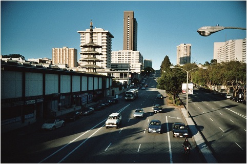
[Photo Credit: flickr user flowertai]
Before the 1950s, though, Geary was home to a number of Muni streetcar lines, also with heavy ridership. Like a number of other lines throughout San Francisco, these fell victim to Muni's move to buses through the middle of the last century. So today there's no sign that Geary was home to some of the city's earliest Muni streetcar lines: the A-Geary ran from downtown to Golden Gate Park (at 10th Avenue), and the B-Geary ran to the ocean, terminating at Playland at the Beach, the former amusement park on Ocean Beach. The density found in even the western reaches of the Richmond today is thanks in part to these streetcars and the mobility they offered. Coming just six years after the devastation of the 1906 earthquake, they helped to hurry along the westward reconstruction of the city in the 1910s and 20s.
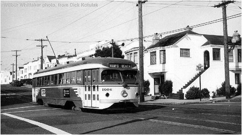
[Photo Credit: flickr user telstar]
Unfortunately for railfans, the city decided to switch over to cheaper bus transportation during the 1950s. Some streetcars like the H-Potrero serving Potrero Hill were canceled due to low ridership, but ultimately the city replaced almost all its rail, even on heavily trafficked Geary. The only lines that survived this switch were those with special rights-of-way, leaving us with the five Muni Metro lines we have today. Meanwhile, Geary was "upgraded" to accommodate the automobile, with additional lanes, underpasses on Fillmore and Masonic, and freeway-style exit ramps. As with elevated rail teardowns in New York, San Franciscans were promised a restored and improved form of rail transportation. During the 1960s, the plan was to construct a Geary branch of the BART regional system:
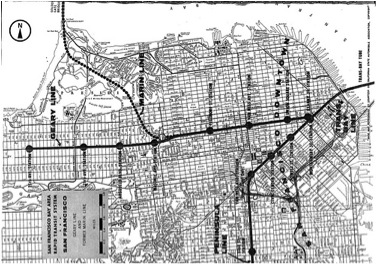
[Photo Credit: flickr user Eric Fischer]
These plans fell through when Marin County elected not to join BART. But plans to bring rail to Geary persisted, with proposals for a Muni Metro subway down Geary and streetcars down California and Balboa Streets appearing in planning documents as late as 1974.
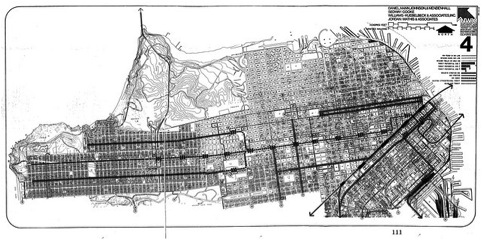
[Photo Credit: flickr user Eric Fischer]
Unfortunately, failure to find funding and pass ballot measures doomed these proposals, and Geary (despite being a relatively dense corridor) was left with local and express bus service that -- though robust -- is limited in its capacity.
On the bright side, the pendulum seems to be swinging back towards transit in the Bay Area, among the plans getting a lot of attention is a proposal to build bus rapid transit along the Geary corridor. While this would not have the speed or capacity of a subway, it would still represent an improvement for getting to the northwestern reaches of the city. The plans currently call for a 2015-16 completion, but they're meeting some local resistance. In an additional ironic twist, the overpasses that made the street more like a freeway are also conspiring to make the BRT plans more complicated. According to Kamala Kelkar for the The Examiner:
Three options exist for dealing with [intersections with overpasses], which include Fillmore Street and Masonic Avenue: have the pedestrians cross three lanes of speedy traffic at a crosswalk underneath the bridges, have them exit on either end of tunnels and walk to their transfers and shopping, or have the buses stay aboveground, which could sacrifice up to 300 parking spots between Van Ness and 33rd avenues, according to documents from the San Francisco County Transportation Authority, the local agency in charge of the BRT.
Hopefully the city can see its way past these roadblocks and bring more transit to Geary — and maybe even a rail line in the medium-term. (Even the idea for a BART line underneath Geary resurfaced in a 2006 Regional Rail Plan alternatives analysis.) But in the meantime, the focus should be on bringing speedier transit, namely bus rapid transit. SPUR's take on the Geary BRT project is available here.