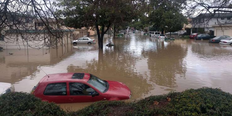
When Coyote Creek flooded in February 2017, it caused an estimated $73 million in property damage to San Jose homes and businesses and prompted 14,000 residents to evacuate, some by boat. The neighborhoods of Rock Springs, Brookwood Terrace and Naglee Park and the South Bay Mobile Home Park, among others, were significantly affected. The immediate response, which involved hundreds of city employees and thousands of community volunteers, tested San Jose’s capacity to respond to an even larger emergency.
In the wake of the flooding, the City of San Jose and the Santa Clara Valley Water District initially responded to criticism from the public by assigning blame to each other, but in the last year the two have begun to work together to improve emergency preparedness. At a recent SPUR forum in San Jose, Ray Riordan from the city and Linda LeZotte of the water district outlined some of the changes their organizations have made in response to the flood and its aftermath.
Working in partnership, both organizations have improved their emergency response capabilities and completed minor repairs to the most flood-prone portions of the creek. However, much of the engineering and maintenance required to prevent future disasters of this kind remains out of their control, forcing them to rely on private property owners and state and federal agencies for critical risk mitigations and communications.
Coordinated Emergency Response
Ten days after the flood, the City of San Jose hired Ray Riordan to be the director of a new Emergency Management Office within the City Manager’s office. His work since has included convening an internal emergency management working group, which had not met since 2004, and revising the city’s emergency plan, the first update since 2006.
A major issue during the flooding was the delay in notifying the public about the seriousness of the event and in calling for residents to be evacuated. This had two causes: miscommunication between the city and water district over creek levels and the probability of a flood event, and unclear protocols for public outreach. As Riordan told the audience at SPUR, prior to the flooding there was no way to get an emergency notice out to the public.
The city is now working with Santa Clara County to get messages out through an online system called AlertSCC, which residents can opt into at alertscc.com. San Jose has also invested in several mobile alert units, which employ long-range acoustic devices that can be heard from a mile away. These were used with success to get information to evacuees returning home after the Santa Rosa fires in the fall of 2017.
The city also partnered with the water district to create a Joint Creek Emergency Action Plan, which the San Jose City Council approved in November 2017. The plan lays out how the two organizations will work together at all stages of flood events, from preparation to communication and response, and aligns with categories used by the National Weather Service to provide consistent guidelines for reporting and to trigger emergency actions. The goal is to establish new protocols for making decisions together instead of independently, and to reduce duplication of effort in the field.
Engineering Coyote Creek
Several improvements have been made in the last year to portions of the creek that experienced significant flooding, including two flood walls at Rock Springs and levee repairs near the mobile home park on Old Oakland Road. These projects were designed to reduce flood risk to adjacent areas without increasing the possibility of flooding downstream. The city is also planning future improvements to its storm drain infrastructure, installing new flap gates to prevent backflow from the creek in the event of future floods.
However, these are only minor improvements, and any substantive engineering work to modify the creek watershed will require federal assistance. Despite evaluating the area following the 1997 floods, the federal government has not considered Coyote Creek a priority project to date. LeZotte told the SPUR audience that the water district is working with state and federal representatives to communicate the need for urgent work to reduce future flood damage. This process is not certain and is expected to take decades if approved.
Plans for a major retrofit of the Anderson Dam are also in the planning phase. The dam is currently held at 52 percent capacity due to seismic concerns. But in the six weeks prior to the February 2017 flooding, Anderson Reservoir filled to the brim and spilled for 10 days: the worst flooding since it was constructed in 1950. Planned spillway improvements would both reduce the danger of liquefaction under the dam and offer some additional flood protection by reducing peak flows, but these are not expected to be completed until 2028 and jurisdictional authority over the dam lies with the state’s Division of Safety of Dams and the Federal Energy Regulatory Commission.
Maintenance and Ownership of Creek Lands
In addition to engineering work, maintenance and debris removal from creek lands can reduce flood risk. However, existing water district programs such as homeless encampment clean-ups and voluntary Adopt-A-Creek programs only address issues on water district property. Large portions of Coyote Creek are considered natural areas, including many of the sections that flooded, meaning the water district is not permitted to clean or maintain them.
Perhaps the most critical barrier to preventing future floods is access to and ownership of creek lands. The water district only maintains 275 miles of the 800 miles of creeks and rivers in Santa Clara County. For the Mid-Coyote Creek area, including areas that flooded, only 10 percent of the right-of-way is owned by the water district. A recent agreement with the city allows the water district to access city property, and LeZotte shared that the agency has since been able to remove sediment, trees and invasive plants that can trap debris and restrict water flow along several acres. The remainder is private property, and responsibility for maintenance lies with private owners. Enforcement lies under the city’s jurisdiction and has been minimal.
The city and water district have made important improvements to shore up emergency response capabilities, update outdated protocols and establish clear lines of communication in the aftermath of the 2017 floods. However, preventing catastrophic damage will require significant funding and approvals from state and federal sources, a change in regulation and the cooperation of hundreds of private property owners. In the meantime, large parts of San Jose built on flood plain remain vulnerable to flooding, and climate change only makes significant weather events more likely in the future.