Our report The Future of Downtown San Jose suggested that the city can bring more people and activity downtown by providing better tools to navigate the area and discover all it has to offer. Our suggestions included adding clearer signage, more real-time information and better wayfinding about destinations, available transit service, bicycle routes and pedestrian paths. In the last few months, San Jose, with support from the Knight Foundation, has been taking big steps to make that happen.
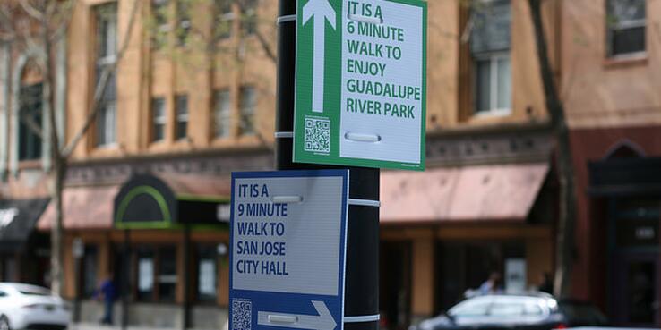
The city is developing a wayfinding program that uses design and informational signs to help people understand, navigate and enjoy downtown. First it partnered with Walk [Your City] to create wayfinding signs that encourage people to walk downtown. The signs let people know that there are lots of things to eat, see and do within walking distance by answering questions like: What’s a nearby destination? In which direction is it? How long will it take me to get there? Designed as temporary prototypes, the signs are the first step in developing a permanent wayfinding infrastructure.
Now, in partnership with City ID — wayfinding specialists who have created programs in cities like New York City, London, Bristol and Moscow — San Jose is moving toward a permanent wayfinding system for downtown. From July 15 through 17, SPUR hosted City ID for a series of walk audits that focused on understanding user needs. Participants were given questionnaires for an on-street assessment. They were asked to rate what they experienced from their own perspective as well as imagine the perspective of other users: visitors who are in town for a convention, elderly of physically impaired individuals or new San Jose State University students, to name a few.
Wayfinding is much more than informational signage. It’s also about incorporating art and design into the city and its transportation network in ways that help build the city’s identity. That includes putting iconic buildings and landmarks on the map, such as the historic Bank of America building, the restored De Anza hotel or the Guadalupe River Trail. Wayfinding can help define networks: transportation, public parks and plazas, retail districts and more. A complete wayfinding system contributes to the quality of places, as well as an understanding of places and how they connect to each other.
Great wayfinding can also help San Jose achieve long-range goals like the ambitious target to cut solo driving in half by 2040. As we’ve talked about before, cohesive wayfinding systems can go a long way toward helping people feel more comfortable using the Bay Area’s 20-plus transportation systems.
Both Walk Your City and CityID will be back in San Jose in the coming months to continue prototyping and developing recommendations for permanent wayfinding.