While living in the suburbs often appears less expensive than living in the city, this is often not the case when factoring in transportation costs. The Center for Neighborhood Technology just released an expanded version of their housing and transportation index which provides a comprehensive view of neighborhood affordability. Unlike other affordability indices, the Housing and Transportation Affordability Index takes into account transportation costs associated with neighborhood design and location. Their website allows users to explore neighborhood-level data about housing and transportation prices which include information on auto ownership, transit use, and housing density that can help Americans make more informed decisions about where they want to live.
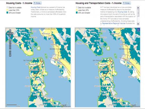
[Map generated on H + T website comparing affordability in the Bay Area]
The H + T Affordability Index is a product of a collaboration with the Center for Neighborhood Technology, Center for Transit Oriented Development and was developed as a project for the Brookings Institution's Urban Markets Initiative. In the works since 2006, the Affordability Index recently expanded its analysis to cover 330 metropolitan areas in the United States, which accounts for more than 80% of the population in the United States and covers more than 161,000 neighborhoods.
SPUR understands the role that effective and affordable transportation options play in affordability and quality of life. Check out SPUR's article on Transit-Oriented Development in the Bay Area as well as our transportation page for more information on how SPUR is working to encourage better transportation options in the Bay Area visit.