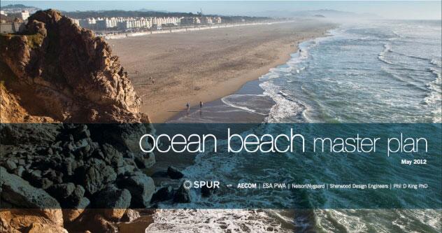
Ocean Beach Master Plan
Creating a sustainable future for San Francisco's coast
Ocean Beach, one of the gems of the San Francisco landscape, faces significant challenges. SPUR led an extensive interagency and public process to develop the Ocean Beach Master Plan, a comprehensive vision to address sea level rise, protect infrastructure, restore coastal ecosystems and improve public access.
The Ocean Beach Master Plan and Implementation Studies were made possible by the State Coastal Conservancy, the San Francisco Public Utilities Commission and the National Park Service.
Future flickers for Ocean Beach bonfires SF Bay News 02/9/2015
VIPs Learn about Climate Change Impacts along San Francisco’s Outer Coast USGS 01/2015
California braces for "storm of the decade" CBS News, 12/9/2014
Why S.F. is moving 42,000 tons of sand down Ocean Beach SF Gate, 12/5/2014
San Francisco, Sonoma recognized by White House for Climate Action SF Gate, 12/3/2014
White House checks out S.F.'s plan to Save Ocean Beach SF Chronicle, 6/20/14
San Franciscans in the Dark about Flood Hazards Climate Central, 06/20/14
SPUR's Plans for Ocean Beach Get Refined and Rendered Curbed, 06/06/14
Is it Time for San Francisco to Declare Defeat in its Battle with the Pacific? TakePart, 05/15/14
Taking Action on Sea Level Rise SPUR, 04/10/14
San Francisco plans expensive ‘managed retreat’ from rising seas Grist, 02/04/13
Ocean Beach Master Plan Envisions Big Changes SF Public Press, 02/04/13
San Francisco a Test Case for Coping with Rising Seas KQED, 02/01/13
New plan crafted to limit Ocean Beach erosion SF Chronicle, 11/02/12
Ocean Beach sand management project wraps up ABC Local News, 09/20/12
Shifting Sands: San Francisco Begins Huge Erosion-Control Project KQED, 08/22/12
Sand Mangement Project to partly close Great Highway OB Bulletin, 08/19/12
Great Highway lane work delayed SF Chronicle, 08/09/12
Mayor Lee Celebrates SPUR Ocean Beach Master Plan SF Mayor’s Office, 07/26/12
Turning the Tide at Ocean Beach KQED News, 07/26/12
Shifting sand to be transported elsewhere in San Francisco SF Examiner, 07/23/12
Ocean Beach sand plan could help curb erosion south of Sloat OB Bulletin 07/20/12
Ocean Beach master plan maps $300M project SF Business Journal, 06/22/12
Stay or go? Communities are eyeing a retreat from sea NBC News, 06/02/12
San Francisco's Coast and the Rising Sea KQED, 04/10/12
San Francisco's Battle With Mother Nature Planetizen, 03/28/12
Coastal Erosion in SF Prompts Planning and Debate KQED, 03/26/12
Both Coasts Watch Closely as SF Faces Erosion The New York Times, 03/24/12
Makeover could mean changes on Great Highway SF Examiner, 11/12/11
OBMP Envisions Big Changes for Great Highway KQED, 11/07/11
Erosion expected to strip economic value of Ocean Beach OB Bulletin, 09/13/11
Erosion problems threaten the future of Ocean Beach ABC Local News, 09/05/11
State panel rejects city's repairs to Ocean Beach SF Chronicle, 07/15/11
Violent Pacific storms of 2010 worst on record SF Chronicle, 07/14/11
Public urged to help decide fixes for Ocean Beach erosion Sunset Beacon, 02/01/11
Forces of Nature are Working to Destroy Ocean Beach The Bay Citizen, 01/25/11
On the Brink of an Ocean Beach Master Plan OB Bulletin, 09/21/10
Is It Worth It to Save Oceanfront Development? The New York Times, 09/13/10
Experts Call for Long-Term Fix for Beach Erosion Sunset Beacon, 11/01/10
Ocean Beach due for an overhaul SF Examiner, 07/08/08
California Climate Change Publications California Climate Change Portal
The Impacts of Sea-Level Rise on the California Coast Pacific Institute
Coastal Regional Sediment Management Project USACE, CA Resources Agency
FEMA California Coastal Analysis and Mapping Project (CCAMP) FEMA
Our Coast Our Future (OCOF) GFNMS, PRBO, USGS
General Management Plan GGNRA
Western Shoreline Plan (Local Coastal Program) SF Planning
Ocean Beach Task Force Summary (2005) Ocean Beach Task Force
Great Highway- Reports, Presentations, and Fact Sheets SFDPW
South Ocean Beach - Shore Management Discussion Bob Battalio, PE