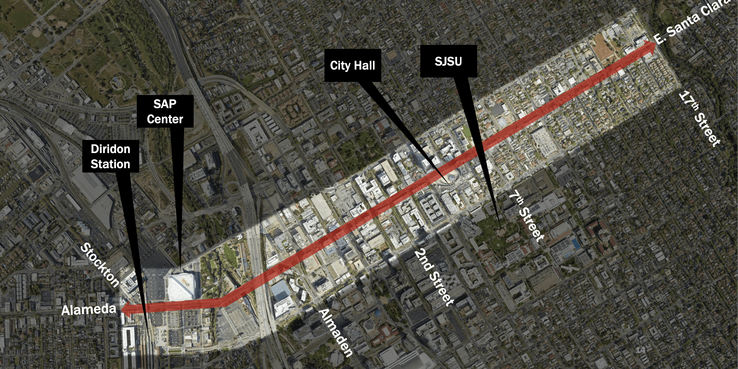
Cities around the world are re-imagining how their streets could function as more welcoming and useful spaces. In one local example, San José is beginning to rethink its main drag, Santa Clara Street.
Remaking Santa Clara Street into a people-focused place is one of four big transportation moves detailed in the San José Downtown Transportation Plan, which the city’s Department of Transportation developed in collaboration with the community to support mobility needs and future growth in downtown.
In spring 2023, the city and SPUR, in partnership with PCA-Stream, Gehl Studios, the San José Downtown Association, and Joint Venture Silicon Valley, convened a workshop to start re-imagining the street as a place for people. Participants walked Santa Clara Street and completed a public life survey. Then, they learned how Paris is “re-enchanting” the world’s most famous boulevard: the Champs-Élysées.
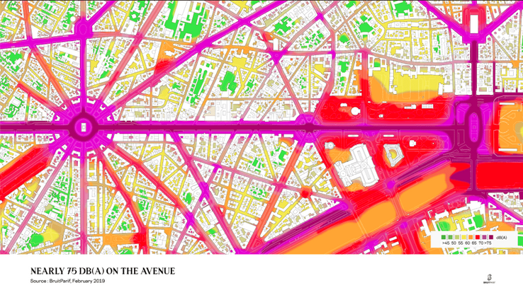
Although the Champs-Élysées may not seem like an obvious parallel for Santa Clara Street, both streets face similar challenges. Chief among those challenges is fast-moving cars that make both thoroughfares noisy, polluted, and unsafe. They are places to pass through quickly rather than to linger.
A good city street extends an invitation to belong. It’s a welcoming, memorable, and safe public space to be. San José’s upcoming planning process is an opportunity to remake Santa Clara Street into a place San José residents can be proud of.
Re-imagining Santa Clara Street requires thinking carefully about what the street means to San José. What was lost when it became a heavily trafficked route no longer safe for kids to walk and bike to school? What kind of community do San Joséans want to be part of? How can the city help residents build that community?
Learning from Paris: “Re-enchanting” the Champs-Élysées
In 2019, a group of civic leaders approached architecture and urban design firm PCA-Stream to complete a study to reimagine the Champs-Élysées. A tourist attraction and home to high-end stores and chain restaurants, the Champs-Élysées is viewed in a negative light by more than 40% of surveyed Parisians. For them, the Champs is noisy, generic, “artificial,” stressful, and unwelcoming.
The civic group’s aim was to “re-enchant” the Champs-Élysées, making it a place that Parisians could be proud of, a place they wanted to be. The group started by looking backward and inward to uncover both the historical and symbolic role of the grand boulevard. It then dissected all the elements that today are collectively creating such an inhospitable place for Parisians.
Source: Lucien Baylac, domaine public
Source: Alamy banque d’images
PCA-Stream next sought to understand the street’s contemporary functions and dysfunctions. It explored how each layer of the street contributes to the street’s functioning as a system — much as the nervous system, vascular system, and muscular-skeletal systems work together within the body.
The group argued that creating a great street requires a multidisciplinary approach that pays attention to human psychology and behavior, natural environment, the built environment, and uses of both. It requires careful attention to the number and proximity of places where people might like to spend time as well as to the ground conditions that can make a place comfortable or uncomfortable. Do residents and visitors have multiple seating areas, playgrounds, sports facilities, and cultural venues to choose from and ways to easily move among them via pedestrian promenades, paths, and squares? Must people endure noisy cars and air pollution when having a conversation or crossing the street?
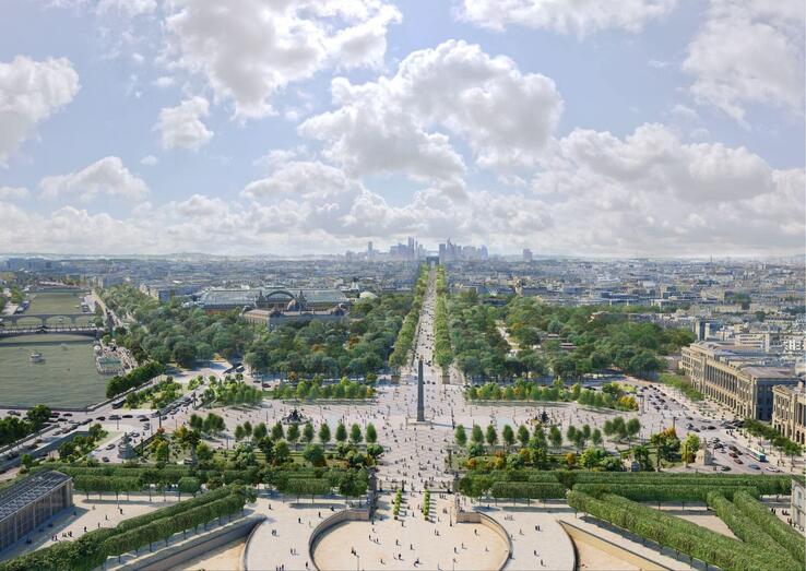
Source: © PCA-STREAM – REENCHANTER LES CHAMPS ELYSEES PHASE II
To re-enchant the Champs-Élysées, PCA Stream made two sequential recommendations:
First, tame the urban highway. Addressing some of the ground conditions that make it hard for people to walk and engage in conversation requires reducing auto traffic. PCA Stream’s proposal slows and removes multiple lanes of vehicular traffic, turning those spaces into protected bicycle lanes, widened pedestrian walkways, new outdoor dining areas, and other types of public space.
Source: © PCA-STREAM – REENCHANTER LES CHAMPS ELYSEES PHASE II
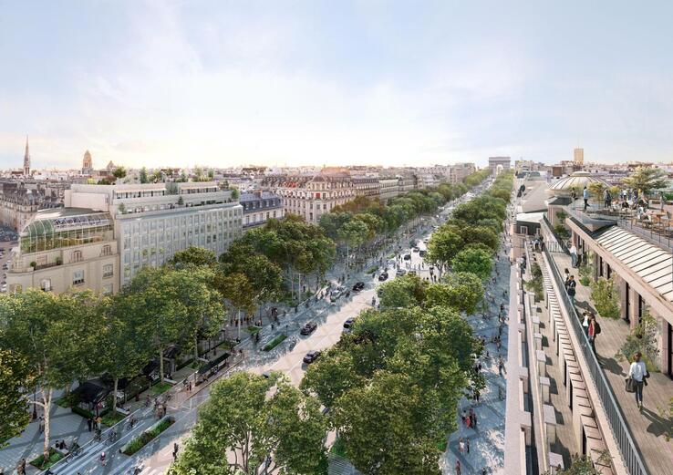
Source: © PCA-STREAM – REENCHANTER LES CHAMPS ELYSEES PHASE II
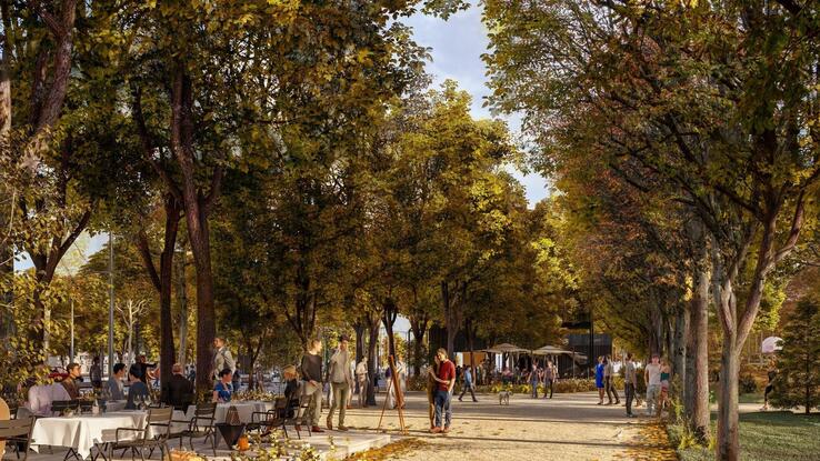
Second, bring back the green spaces. The flow of cars has fragmented the gardens that almost continuously lined the boulevard in its days as a promenade, carving them into separate and nearly abandoned green spaces. PCA-Stream’s proposal calls for revitalizing and re-connecting these green spaces and for knitting them together with other urban elements such as street trees and plant lounges with seating. This strategy is intended to create a more welcoming space, to cool the street and support climate action, and to add much-needed recreational areas in Paris, which has far less green space than peer cities.
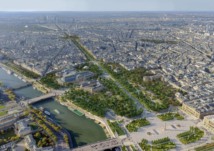
Source: © PCA-STREAM – REENCHANTER LES CHAMPS ELYSEES PHASE II
Source: © PCA-STREAM – REENCHANTER LES CHAMPS ELYSEES PHASE II
Reinventing Santa Clara Street
Building on PCA-Stream’s approach, workshop participants walked along four segments of Santa Clara Street to examine how natural elements, the transportation system, the built environment, and infrastructure and its uses function today, as well as how it feels to walk on the street. Here is some of what we heard when we asked participants to reflect their experience:
“There are a lot of cars but not a lot of people.”
“It’s a transient place. People grab a coffee and leave.”
“It’s historic, but decaying.”
“There are a lot of green spaces, but they’re disjointed. There are individual focal points, but they’re not continuous, so you don’t want to keep walking.”
“Lost potential for beauty.”
Two themes emerged from participants’ observations.
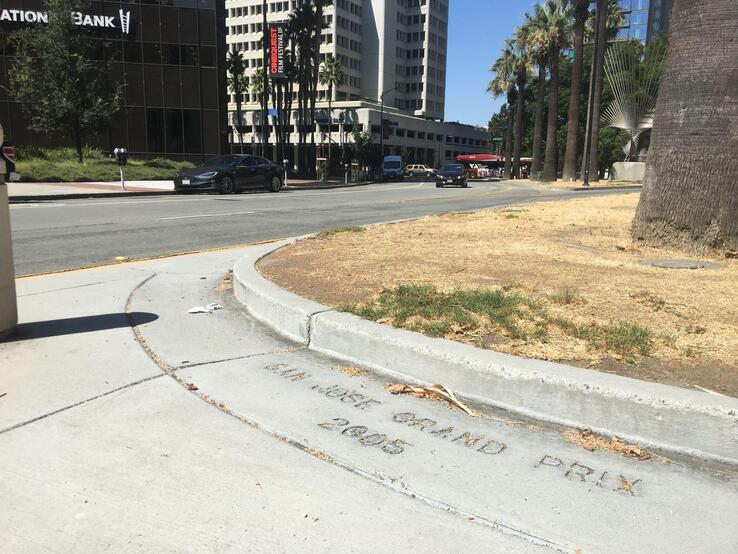
Theme 1: Cars are given too much space on the street, making it both unpleasant and unsafe. Over the years, city planning decisions that privilege high-speed driving have made Santa Clara Street a risky place for pedestrians and other users. For instance, the intersection of Almaden Boulevard and Santa Clara Street was redesigned in 2005 to accommodate the San José Grand Prix. According to data provided by the City of San José’s Department of Transportation, cars have killed 8 people and injured 220 more on this portion of the street alone just since 2019.
Source: Nicholas Frey, City of San José Department of Transportation
Santa Clara Street is becoming safer now that the city has reduced the driving speed in downtown to 20 miles per hour and adopted a citywide transit-priority policy to help buses more easily navigate car traffic. But more can be done. Workshop participants offered a number of other ideas to remedy Santa Clara Street’s auto-centric design, including, but not limited to
- Repurposing street parking for wider sidewalks and protected bikeways
- Repurposing turn lanes into planted medians
- Shortening distances between crosswalks and pedestrian refuge islands
- Investing in transit to get to and through central San José without a car
Theme 2: The current urban design of Santa Clara Street does little to showcase and strengthen the city spine’s history, culture, and character. Four stretches of Santa Clara Street have a distinctive character. For example, the area east of North 7th Street feels like a neighborhood, but the stretch between Almaden and North 2nd Street feels like a mixed-use area featuring businesses, nightlife, and entertainment. Elements of distinction and elements of continuity could be brought in to further strengthen and define a sense of place while creating the sense that similarly delightful yet different experiences await just down the street.
While distinctive one from another, the four stretches of Santa Clara Street should be unified with repeating design elements that beautify the street. Workshop participants suggested that such elements could include sidewalk pavement, tree plantings, plant bed gravel, outdoor seating, and lighting of one type.
The planning portion of the effort to reimagine Santa Clara Street is expected to take approximately 18 months. To involve residents and other stakeholders in the process, the city expects to establish a community working group and offer public engagement activities, including formal public meetings, design charrettes, and “pop-ups” at community events. The city also expects to seek community input at several junctures during the process. In early 2024, it will seek input on existing street conditions. Later in the year, it will seek ideas for development of alternatives for the street. In 2025, it will seek comments on a draft plan.
The effort to re-envision Santa Clara Street is part of a larger effort to create a more dynamic urban center that befits an increasingly urban city. By embracing urban design principles that prioritize community engagement, walkability, inclusivity, and small businesses, the city can create a main street that is attractive to residents and visitors and supportive of the local community. Investment in that effort couldn’t be timelier or more important.