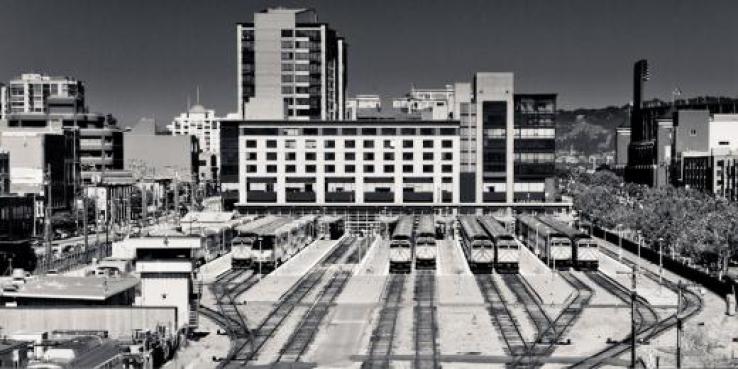
Could the Caltrain station and railyards at 4th and King streets be San Francisco’s next big planning opportunity? The current station is the node that links San Francisco to Silicon Valley and the peninsula. It’s also the hub of an extraordinary network of Muni rail lines: the N Judah, the T Third and soon the Central Subway, which will run down 4th Street before heading underground to Chinatown and North Beach. In addition, the area is served by numerous Muni bus lines. Very few places in the country enjoy this level of transit accessibility.
On the same site as the station are the Caltrain railyards: 19 acres stretching from 4th Street to 7th Street between King and Townsend. The railyards form an enormous barrier between Mission Bay and SoMA. Pedestrians, bicycles and vehicles can only cross the site at one intersection, and a tangle of 280 freeway ramps clutters the southwest edge of the site. Putting the right type of development here could knit together the surrounding neighborhoods, capitalize on the extensive transit access — and even help pay for important transportation projects.
The Caltrain station and railyards at 4th and King and surrounding neighborhoods. Image courtesy SF Planning Department.
A significant amount of regional transit planning is currently taking place in this area. Caltrain will be extended from 4th and King to San Francisco’s downtown, terminating at the new Transbay Transit Center. Caltrain itself is undergoing a transformation, replacing diesel cars with electric ones that will run more quickly and allow for faster turnarounds, thereby enhancing service. And high-speed rail will ultimately connect San Francisco to Los Angeles, with multiple trains per day stopping at 4th and King before heading to the Transbay Transit Center.
In our 2007 report A New Transit First Neighborhood, SPUR explored the opportunity to develop new buildings over the Caltrain station (using air rights, the rights to develop over a piece of land or infrastructure) as an opportunity to pay for expanding Caltrain and bringing high-speed rail into the Transbay Transit Center. Maximizing the transit oriented development opportunities at the 4th and King railyards could support one-time and on-going revenue for both transportation projects while also helping to better weave together Mission Bay, West SoMA and the Central Corridor.
Now the San Francisco Planning Department is considering ways to build on the railyards. The department recently released a report analyzing development opportunities for the site as a means to pay for transit improvements while knitting together the fabric of the adjacent neighborhoods at the same time.
Developing the Railyards: Three Options
The study outlines two development scenarios for the site: one where the air rights above the railyards are developed while the railyards remain in use (which would require decking over the railyards), and another where the railyards are moved to a new location allowing the entire site to be developed as a blank slate. The second scenario has two variations.
Here’s a summary of the three options:
Scenario 1: Decking Over the Railyards
The air rights scenario is consistent with existing high-speed rail and Caltrain plans, which presume that the railyards will remain in their current location. However, the need to deck over the railyards presents significant design and construction challenges, curtailing the ability to do good urban design along the edges of the site and limiting the amount of money the city could recapture for transit and other public infrastructure improvements.
Scenario 2.1: Moving the Railyards, Keeping the Freeway
The two “no railyards” scenarios present much better options to develop the site. The first of these assumes that the freeway ramps will remain as they are. This option allows for a better mix of uses and a better pedestrian experience than Scenario 1. It also allows for much more development capacity. However the value of the land is hampered by its proximity to Highway 280.
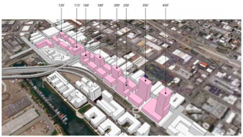
Concept for Scenario 2.1, in which the railyards are moved. Image courtesy SF Planning Department.
Scenario 2.2: Moving the Railyards, Removing the Freeway to 16th Street
This scenario is similar to the one above, except that the urban design and pedestrian experience would be even better due to the removal of the freeway ramps. Development becomes even more valuable when Highway 280 is replaced with a surface boulevard, allowing for greater value recapture.
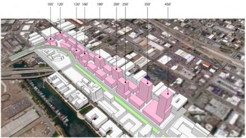
Concept for Scenario 2.2, in which the railyards are moved and the freeway ramps are removed. Image courtesy SF Planning Department.
In Scenarios 2.1 and 2.2 the potential value that could be created for the public sector ranges from $148 million to $228 million, presenting a substantial opportunity to fund transportation improvements in the area.
SPUR is excited about these proposals, particularly the ones outlined in Scenario 2. We hope that that San Francisco will begin to take the steps needed to bring them to reality.
Read the 4th and King Railyards Study >>