As America tries to grapple with increasingly difficult social and environmental problems— reducing greenhouse gas emissions, while finding places for millions more residents of the country - some of the most effective solutions are actually well-known. The basic idea that lies at the heart of the sustainable-planning agenda may hold the key: We should concentrate people near transit. Instead of spreading outward into farmlands in the form of suburban sprawl, which requires people to drive for virtually every need, we should be building upward, within already urbanized areas.
This has been SPUR's long standing agenda and it increasingly defines the agenda of the leading environmental organizations in the United States. But here in San Francisco, we are actually missing some of the greatest opportunities to "think globally, act locally." We are failing to take advantage of the some robust, high-quality rail transit that already exists, right under our noses.
![]()
SPUR has developed the following paper as "think piece" about one opportunity for increasing density near transit. We explore the area near the Caltrain station, at Fourth and King streets, where rail from the Peninsula meets Muni's N-Judah, T-Third and, soon, the Central Subway. We show how the Caltrain rail yards could be built on, as is done in many cities all over the world, and we call for a major upzoning within walking distance of this rail hub. We also call for the City to use revenues from new development to improve the public features of this area and to help pay for the costs of extending Caltrain to downtown, or other improvements to Caltrain.
This is not a detailed zoning study or a community-based planning effort. It is instead a sketch of some ideas for concentrating a larger share of Northern California's growth in places that will allow residents to enjoy urban amenities and live in a more environmentally sustainable way. We hope this provokes thoughtful discussion in San Francisco and the broader region about how to plan for high-quality, sustainable forms of development over the coming decades. Our message is simple: Let's start by giving as many people as possible the chance to live or work near the transit we already have.
![]()
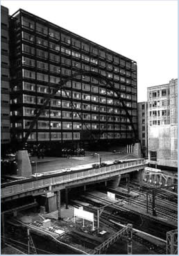
The rail yards at Fourth and King streets divide Mission Bay from the neighborhoods to the
north. Building above the yards, as other cities around the world have done, would knit the
neighborhood back together, make better use of this transit infrastructure and generate funds to improve Caltrain.
A hub of local and regional rail transit
The Caltrain station at Fourth and King streets is the node that links San Francisco to Silicon Valley and the Peninsula. Today, passengers make about 15,000 trips to and from Caltrain, a number that is projected to grow dramatically over the coming years, making Fourth and King an important regional destination.
This station is also the hub of an extraordinary network of Muni rail lines - the N-Judah, the T-Third, and soon the Central Subway, which will run down Fourth Street before heading under Market Street to Chinatown and North Beach. In addition, the area is also served by numerous Muni bus lines. Very few places in the country enjoy this level of transit accessibility.
![]()
A transit first opportunity
Caltrain's surface rail yards, which run from Fourth to Seventh streets between King and Townsend streets, represent an enormous opportunity for San Francisco. If we develop on top of the rail yards, we can use the revenue from the development to help pay for extending Caltrain to downtown and for related improvements to Caltrain.
Similarly, if we upzone the land to the north of the station, we can use the revenue from the development to build parks, sidewalk amenities, affordable housing, bike lanes and other public improvements for the neighborhood.
In both cases - development over the rail yards and upzoning in the adjacent neighborhood - we would reduce sprawl in the region, giving more people the chance to live or work in a transit-accessible location, while knitting Mission Bay together with the neighborhoods to the
![]()
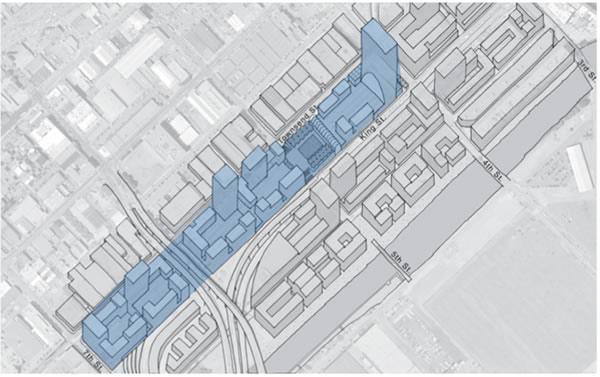
Scope of the study
SPUR convened a task force to examine development opportunities for the Fourth and King Caltrain station and the planning issues facing the adjacent neighborhoods. We focused on the area within easy walking distance of the existing station exit for the simple reason that this is the best place to add significant new uses, whether of housing, jobs or other activities. The overriding planning imperative of our age is to organize our regions so that most people live and work in places where they have the opportunity to take transit and walk. This diagram shows the area within a quarter-mile and half-mile from the Caltrain station.
![]()
Current conditions
Currently there are very low-intensity uses near the station to the north. Parking lots, short buildings and other opportunities for more productive uses abound. Transit of this quality is rare in the world. We are not yet taking advantage of it.
![]()
Plan area adjacencies
The Fourth and King Caltrain station is at the center of a part of San Francisco undergoing remarkable change. Mission Bay is being built out to the south. Active planning work is under way in East SOMA, West SOMA and Showplace Square. We purposefully set aside the geographic boundaries of various ongoing planning processes for the purposes of this exercise, and focused instead on areas within walking distance of the Caltrain station. Our belief is that all of the planning work for the historically industrial areas of San Francisco should be paying more attention to the location of already-existing transit infrastructure, concentrating density there before turning to areas that will require expensive new transit infrastructure to support new development.

The station and the rail yards
The rail yards at Fourth and King streets encompass nearly three full city blocks between Fourth Street and Seventh Street, and King and Townsend streets. These three blocks account for more than 16 acres of land, forming a barrier between SOMA to the north and Mission Bay to the south.
Catellus Land Development Corp. (now a division of Prologis) owns the land on which the rail yards operate, but the state Department of Transportation holds the legal right to purchase the property ahead of any other potential buyer. Caltrans exercised its option in 1986, although the land has not yet been transferred to the department. Once Caltrans takes possession of the land, Catellus will continue to own the rights to develop above the property, starting at a height of 30 feet above the ground. In other words, Caltrain will have the right to use the area up to 30 feet above the ground, while Catellus will have the right to develop above.

Precedents

Montparnasse
Parisians have long known that their seven major railroad stations need to serve more functions than just transportation in that dense, urbane city. The Montparnasse station has 24 rail tracks where 50 million passengers annually arrive and depart via high-speed rail and other trains from the west and southwest of France. In 1994, landscape architects François Brun and Michael Péna built the Atlantic Garden, an 8.5-acre pleasure ground surrounded by residences, over the busy rail yards and station. In addition, other Parisian railway stations also have been decked over for public uses. The Austerlitz station, with 21 tracks and 25 million annual passengers traveling to and from the south of France and Spain, is being expanded to accommodate 40 million passengers by the year 2020. The new decking over the rail yards provides the site for the François Mitterand National Library, the centerpiece of a brand-new town-in-town, Paris Left Bank, which also has thousands of new residences as well as office buildings, schools and parks. West of Paris, yet another new town, La Défense, is built over national rail lines, regional rail, local subways and bus lines, and, based on its great accessibility, has become a major office center for western Europe.

Hudson Yards
Manhattan is planning to create its third high-rise business district on the site of the Hudson Yards. As of this writing, the city is expecting more than $1 billion in revenue from developers, who will bid for the rights to build on top of the yards that serve the Long Island Railroad. Interestingly, this project was initiated by the Regional Plan Association, a civic-planning
group like SPUR. This image is drawn from a 2004 RPA report.
Broadgate
Located above and beside the railway approaches to the Liverpool Street station in London, Broadgate is a multi-acre office and retail complex.
Recommendation
1. Build over the Caltrain rail yard
We can use development above the tracks to knit the neighborhood back together, while contributing to the creation of a lively, walkable urban place. The specific elements of our concept include:
- A grand public entrance to the train station
- A landmark 300-foot office tower at the east end of the development, set back behind the public entryway
- A mix of housing and office over the rest of the site. Our design study generated 1.9 million square feet of office space and 778 units of housing.
- A publicly accessible stairway that bridges the site and continues Fifth Street across it. This aligns with the Fifth Street pedestrian bridge that is already being built over Mission Creek.
- A public park adjacent to the Fifth Street pedestrian through-way.
- Street-fronting retail along the ground level of Townsend and King streets (from Fourth to Seventh streets) to line the edge of the site and activate the street
- Sustainability features throughout the project, specifically by requiring developments to meet a LEED-Gold or LEED-Silver green building standard.1
Of course, none of these ideas should be taken as carefully elaborated design proposals, from an engineering, urbanistic, operational, architectural, market or political perspective. However, these are concepts that we think merit careful consideration.
From an urban-design perspective, the ideal solution would be to depress the Caltrain tracks below ground level so that the buildings and the street could be at the same grade. However, this solution would be extremely expensive to do because the tracks would need to run beneath Mission Creek. This entire area was originally either open water or wetlands, and it drains a large watershed. Mission Creek also is the site of a major sewer outfall. Putting anything underground, therefore, would be very expensive. At this point, we simply do not know whether placing this rail infrastructure underground would be feasible or not.
2. Use revenue from the rail yards development to pay for Caltrain improvements
A preliminary analysis of the redevelopment of the Caltrain rail yards at 4th and King shows that approximately $ 190.5 million in residual land value could be generated under the base development plan. In other words, this is what we estimate Caltrain could receive by allowing developers to bid for the right to develop above the rail yards. These funds could be reinvested in improvements to Caltrain, including grade separation at 16th Street, creating a "Mission Bay South" stop, electrification or bringing Caltrain downtown to the Transbay Terminal.
Our analysis is based on the following assumptions:
Of course, if more development were allowed at the site, more residual land value would be available. We developed an alternative scenario that generates $407.5 million in residual land value that could be made available to fund the extension of Catrain to downtown.

3. Upzone the neighborhood to the north of the Caltrain station
We believe that a combination of small-plate towers and mid-rise construction of not less than 85 feet in height would be an appropriate way to take advantage of both the existing and future transit infrastructure.
In order to support a walkable and livable neighborhood around the intersection of Fourth and King streets, we propose streetscape, circulation and open-space improvements, as described later in this article.
We also support the creation of affordable housing through a combination of strategies, including inclusionary housing, land dedication and moderate-income "affordable by design" strategies.

4. Public realm improvements: I. Circulation
Major improvements on Fourth, Fifth and Townsend streets are critical to improving the overall circulation of the area. Making Fourth Street and Seventh Street two-way streets, while making it easier to connect with Fifth Street across the rail yards, would help to knit together SOMA, Mission Bay and Showplace Square.
North of the station in SOMA, there are several alleyways that have been blocked off by buildings, disrupting the historic street grid. SPUR supports restoring alleys such as Welsh Street and Freelon Street. Wherever possible, alleys should be designed as "living streets" - streets that are designed for pedestrians but that allow cars.
Making streets two-way and enhancing the alley network are both strategies for connecting the parts of this area to one another and making it easier and more pleasant to walk the large blocks south of Market Street.

II. Turn Fourth Street into a "complete street"
Connecting the Caltrain station at Fourth and King streets with the future Central Subway stations, Fourth Street needs to become more pedestrian-friendly.Recommendations include:
- Make Fourth Street two-way. This would reduce traffic flow and make the street safer and more pedestrian-friendly.
- Add bike lanes and widen sidewalks, in addition to the Central Subway running on the surface, in the center lanes.
- Line Fourth Street with taller buildings with active ground-floor uses. Building heights should be 85 feet at minimum, with taller buildings anchoring major transit intersections.
- Reinforce connections with other transit modes.

III. Improve Townsend Street
Located directly to the north of the rail yards, Townsend Street deserves some attention. It has never been officially "accepted" by the Department of Public Works because it is so far from meeting general standards for streets. There is an opportunity to balance the urbanistic goals of creating a human-scaled place with the the operational needs of Caltrain:
- Create a multiuse path along the south side of Townsend Street for bicycles and pedestrians.
- Activate ground-floor uses on the south side of Townsend Street, assuming that the rail yard's edge can be encroached on slightly.
- Add sidewalks on the north side of Townsend Street.

IV. South Park West
We have identified an opportunity to create a new mid-block park similar to South Park on a City-owned lot between Brannan, Bryant, Fourth and Fifth streets. This park would be roughly parallel to South Park, two blocks to the west. Zoning the alleys surrounding the parks for a mix of uses would encourage active uses around the park. We recommend designating a 45-foot building height on the alleys, but allowing taller heights stepped back from the lot line, while being mindful of sun access to the park. Value created by development in this area could be used to pay for the park.
A plan at this scale has the possibility to alter primary flows of water and energy in the area, not just flows of people. The mid-block park proposal could be envisioned as a district-serving wastewater-treatment facility. This would benefit the whole city by reducing combined sewer overflows and the total volume of waste pumped to the Southeast plant - an environmental- justice issue that also consumes a large amount of energy to pump waste to the plant. The groundwater available on the site could be used within buildings for many uses, making the city more drought-resistant and potentially seeding a larger reclaimed-water district in SOMA. Buildings in this multiblock area could be sculpted to enhance wind-power potential based on aerodynamic studies, or arranged for passive solar designs and solar electric-power generation.

Conclusion
The area around the Caltrain station at Fourth and King streets provides a tremendous opportunity to concentrate jobs and housing near a major rail-transit line. If we plan for this opportunity carefully, we not only have the opportunity to make major improvements to public areas south of Market Street, but we can also generate almost 200 million dollars to pay for extending Caltrain downtown or other improvements to Caltrain.
The Bay Area is projected to grow by more than 1 million people and nearly 1 million jobs by 2025. Where those people live and work will have a major impact on the environmental health of the region. The basic answer is clear: we should concentrate people where they can walk and take transit - in places like the neighborhood where Caltrain, the N-Judah line and the Central Subway meet. Ecological concerns and urbanism are two sides of the same coin: How we build cities determines how much ecological impact we have as a species.
Endnotes
- LEED is the green-building rating system of the U.S. Green Building Council.