This article is excerpted from the SPUR report After the Disaster.
Read the complete report >>
See all reports in SPUR's Resilient City series >>
The next major earthquake that hits the Bay Area will wreak havoc on our transportation system. Transit lines will collapse and rail tracks will be broken. Transbay road, rail and public transit links will be disrupted. Highways and surface streets will be closed by the failure of pavement and the accumulation of debris. Power system failures will immobilize electric-powered transit, including BART and Muni. Maintenance facilities such as yards and garages will be damaged. Airport runways will be rendered unusable. Even worse, damage to the transportation network will limit the ability of firefighters, public safety officers, utility workers, debris removal teams and medical personnel to travel where they are needed.
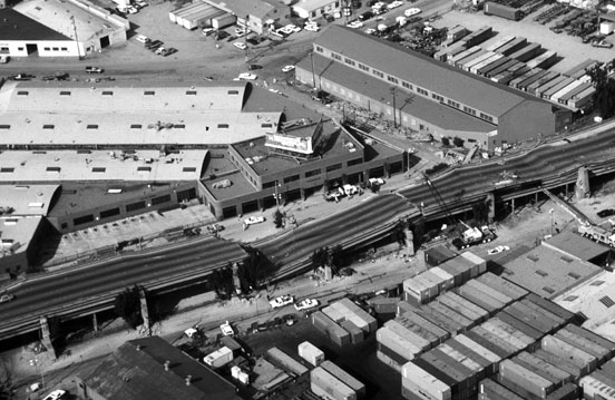
Aerial view of collapsed sections of the Cypress Freeway of Interstate 880. Photo by H. G. Wilshire for U.S. Geological Survey.
This article excerpts a report from SPUR's Resilient City series. The report focuses on one essential component of our infrastructure — transportation — and proposes a plan to rebuild quickly and effectively after the disaster, while increasing our resiliency in the process.
Much depends on getting the transportation aspects of our disaster planning work right. Failure to plan for the recovery of our transportation system after an earthquake likely will create a number of problems:
- out-migration of workforce and jobs
- delays in the restoration of infrastructure caused by lengthy regulatory and contractual processes
- debate over the allocation of recovery funds
- protracted fuel and water shortages and increased delivery costs
- constrained transportation access to and from the region
- loss of overall regional competitiveness
- politicization of restoration projects
SPUR believes that San Francisco's resiliency relies on the redundancy of our transportation network. When one piece of infrastructure in a transportation corridor fails, there must be another way to get people and goods where they need to go. This article focuses on the transportation network—the bridges, tunnels, rails, vessels and roadways—that serve San Francisco. We analyze the corridors that connect the city to the surrounding region, as well as the transportation network within San Francisco.
Our transportation infrastructure and where it is most vulnerable
The City of San Francisco and the entire Bay Area are vulnerable to natural disasters, particularly earthquakes. While other disasters, such as fires, industrial accidents, landslides, tsunamis and acts of terrorism are also possible, a major earthquake is the most likely event for which our regional emergency planning prepares.
Among the many faults that cleave Northern California, the Hayward and San Andreas faults pose the greatest threats. The 1906 earthquake and fire was the "Big One" of the 20th century, caused by movement on the San Andreas Fault and exacerbated by the vulnerabilities of the City's utility infrastructure and buildings. The 1906 earthquake is estimated to have measured 7.9 on the moment magnitude scale—a scale seismologists use to measure the energy released by an earthquake, instead of the Richter scale more commonly known by the general public. Together, the earthquake and the consequent fire destroyed three-quarters of the city—more than 500 square blocks—and are estimated to have claimed 3,000 lives. The 1989 Loma Prieta earthquake was also caused by movement along the San Andreas Fault measuring 6.9 on the moment magnitude scale. While effects on transportation facilities were localized, some of the most necessary restoration has yet to be completed—more than two decades after the event.
It is assumed that the next big earthquake will be more intense than the 1989 Loma Prieta event, and could easily sever transportation links to the north, east or south. It is impossible to predict which links will break, but it is possible to envision a break in each link and to prepare for those events.
Planning for the expected versus extreme earthquake
SPUR's Resilient City effort pegs performance goals for all the major "lifelines" (vital transportation systems and other infrastructure) to the "expected earthquake"—that is, the seismic event that is likely to happen within the lifetime of the infrastructure. SPUR's "Before the Disaster" seismic performance goals are stated in terms of general states of damage and repair over an extended recovery period, under the assumption that an expected earthquake has occurred. We chose the expected rather than the extreme earthquake because it is a major event that can reasonably be expected to occur once during the useful life of a structure or lifeline system. However, for purposes of planning for actions that should be taken to restore transportation systems following an earthquake, a more extreme earthquake should be considered to ensure that preparations are sufficient for San Francisco to recover from a potentially much greater disaster. Additionally, because earthquakes on different faults will likely have different effects on transportation systems around the region, the effects of different earthquakes should be considered.
San Francisco's transportation corridors
San Francisco depends on its transportation infrastructure for its livelihood: for delivery of goods, tourism, shopping and getting people to work. After a disaster, especially a major earthquake, many vital transportation links may well be broken. The economy of the city depends on restoring those links quickly. To maintain the viability of San Francisco as a major employment center, temporary links must be established as soon as possible. If businesses realize they cannot function in San Francisco, within as little as weeks they will likely relocate to other cities, whether in the Bay Area or beyond. If they believe that rebuilding will hamper normal operations for years, firms with multiple locations in the world will be especially likely to shift work to other offices.
Our resiliency depends in part on the ability of transportation systems to withstand an earthquake, and on the speed and efficiency with which they are restored when they do fail. In San Francisco, the transportation network includes the public transit and surface street networks administered by the Municipal Transportation Agency, and the waterfront, administered by the Port of San Francisco—all wholly under the auspices of the City and County of San Francisco. However, as San Francisco is a focal point of the Bay Area, other transportation systems that are part of the regional network are vital to the city's recovery, including BART, AC Transit, Golden Gate Transit, SamTrans, Caltrain, Amtrak, the Port of Oakland, San Francisco International Airport, the Transbay Joint Powers Authority, Water Emergency Transportation Authority, and Caltrans. The failure or debilitation of any of these regional systems could paralyze San Francisco and the region.
Liquefaction zones in San Francisco
[ Click to enlarge ]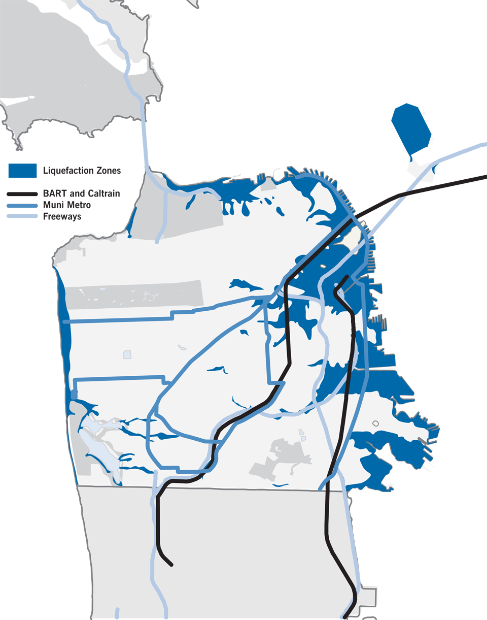
Much of San Francisco's transportation infrastructure is concentrated in downtown and South of Market. Unfortunately, these are also liquefaction zones, and therefore very vulnerable to the effects of an earthquake. Source: California Department of Conservation, Division of Mines and Geology, final edition February 2003.
Key system vulnerabilities
When considering the expected earthquake, plans should address the likelihood of vital transportation system failures:
Liquefaction of poorly consolidated soils may cause tremendous damage to both the highway and street systems vital to San Francisco (see Figure 4.). The principal areas of concern are the Bay Bridge toll plaza in Oakland and northbound Highway 101 in San Francisco. Liquefaction may also affect I-80 between Emeryville and Vallejo, a very important lifeline connecting East Bay communities to employment in San Francisco. The Embarcadero, South of Market and Mission Bay areas are all constructed on soils that may liquefy.
Power outages, continuing or sporadic, may immobilize the San Francisco Municipal Railway's electrically powered lines, at least temporarily. These lines include trolley coach, light rail, cable car and streetcar lines. Diesel or hybrid buses may be the only means available to provide emergency or basic mobility.
Road damage and debris may constrain movement for transit or personal vehicles. Damage should be anticipated in such areas as the Embarcadero, South of Market, the Marina and China Basin, and in general on surface streets on poor soils. This is a particular concern in the SOMA neighborhoods (as it was in 1906), as well as throughout the financial district. On Market Street the pavement may be disrupted and power lines may be down. Mobility in the Tenderloin may be limited by both debris and displaced people. Chinatown and parts of the Mission District may also face serious problems with debris removal and displacement of vulnerable populations such as the elderly.
Transit access to San Francisco will be constrained, at least temporarily. The transbay tube is vulnerable, as BART has not yet completed its seismic retrofitting. After an earthquake, the tube will be closed temporarily for inspection even if the tube does not fail. Damage to approaches and surface streets at either end of the Bay Bridge may limit bus access to San Francisco.
Fixed facilities, including offices, stations, depots, yards and garages for transit systems likely will suffer damage that could affect operations. In the recent Chilean earthquake, even as structures generally performed well, non-structural damage did occur and resulted in some loss of services. In the Bay Area, fueling systems may be damaged and unusable for several days, pavements and soils may fail, and lighting and power systems may not function even if there has been little structural damage.
Ferry service demand may vastly exceed supply. Temporary ferry terminals may need to be created, to transport passengers between San Francisco and the East Bay cities. Vessels may have to be procured under mutual aid agreements to provide the requisite system capacity.
What happened after Loma Prieta?

Image: Collapsed section of the San Francisco-Oakland Bay Bridge. Courtesy of the U.S. Geological Survey
While the effects of the Loma Prieta earthquake were minor in comparison with those of recent earthquakes (for example, the 2010 earthquakes in Haiti, Chile, China and the Baja California region of Mexico), it still had a substantial impact on the Bay Area's transportation system.
- Bay Area Rapid Transit: The BART rail system, including the transbay tube, was virtually undamaged and closed only for post-earthquake inspection. As one of the few means of transbay access into San Francisco in the days following the earthquake, daily ridership increased by 124,000, a roughly 50 percent jump, in the week after the earthquake (from 218,000 to 342,000). Today, ridership is at the post-Loma Prieta level of 342,000 passengers per day, which means there is less flexibility in the system to accommodate the spike in trips that would occur after a major disaster. If transbay demand increased by a similar proportion, the BART ridership would spike from 342,000 to over 500,000 daily riders. If gas prices and transit ridership both continue to rise, daily BART ridership will likely exceed the high of 374,000 average daily riders that was reached in July to September 2008 prior to the economic contraction.
- San Francisco-Oakland Bay Bridge, Interstate 80: The Bay Bridge was repaired and reopened to traffic in just one month. However, the earthquake made it clear that the Bay Bridge, like many of California's toll bridges, required major repair or replacement, for long-term viability and safety. The replacement of the eastern span of the Bay Bridge has been in planning, design and construction for two decades, and still is not complete.
- Cypress Freeway I-880: The Cypress Freeway, a 1.6-mile long, bi-level elevated freeway constructed of reinforced concrete with four lanes on each deck, collapsed between the MacArthur Maze (the convergence of Interstate highways 80, 580 and 880 east of the San Francisco-Oakland Bay Bridge) and 16th Street in Oakland, claiming 42 lives. Completed in 1997, a single-level elevated freeway structure around West Oakland replaced the Cypress Structure, enabling the neighborhood previously divided by the freeway to be re-unified.
- Central Freeway, U.S. Highway 101: San Francisco's Central Freeway (part of U.S. Highway 101 and a link to the Bay Bridge) was another concrete double-deck structure. It did not collapse, but was torn down and removed ultimately. Originally terminating at Franklin Street and Golden Gate Avenue near San Francisco's Civic Center, the section past Fell Street was demolished first, followed by the section between Mission and Fell streets. The section from Mission Street to Market Street was rebuilt (completed September 2005) as a single-deck elevated freeway. The remainder was replaced as a surface boulevard on Octavia Street.
- Transbay ferries: Ferry service between San Francisco and various points in the East Bay (Oakland, Richmond, Berkeley, Alameda, etc.), was expanded and invigorated during the month-long closure of the Bay Bridge, as an alternative to the overcrowded BART transbay services. The Vallejo Baylink ferry service, started in 1986, saw a big increase in ridership during Loma Prieta earthquake recovery. Within one week after the earthquake, three vessels were put into operation between Vallejo and San Francisco. The passenger-only ferry services maintained their popularity after the earthquake and are a mainstay of the North Bay commute market. In the immediate aftermath of the 1989 San Francisco earthquake, Red and White Fleet provided free transportation to 15,000 stranded commuters and initiated new services to Richmond and Oakland with an expanded fleet of ferries borrowed from operations outside the Bay Area.
- Embarcadero Freeway, state Route 480: The earthquake forced the closure of San Francisco's largely unloved Embarcadero Freeway (state Route 480). It was replaced with a surface boulevard with a dedicated right of way for Muni, opening up San Francisco's eastern waterfront to public access.
- Southern Embarcadero Freeway, Interstate 280: Seismic damage also led to the long-term closure of Interstate Highway 280 in San Francisco (north of Highway 101), another concrete freeway. The highway, which has double-deck segments, remained closed for seven years as restoration plans were debated, delayed and finally implemented. The City is considering, as part of the high-speed rail system, pulling the freeway south to Cesar Chavez and replacing it with a surface boulevard. In that event, the seismic considerations would be greatly reduced.
Loma Prieta made transbay travel between the East Bay and San Francisco completely rail and water-dependent. During the one-month closure of the Bay Bridge, transit use from the East Bay peaked and automobile use dropped. The Bay Area improvised, since there was no regional plan to deal with the emergency. With a larger and more destructive earthquake, we may not be so lucky.
Corridor Failure Analysis
How much redundancy do we have in our transportation system? What do we do when one of our major transportation links fails? SPUR analyzed this issue by looking at redundancy on a corridor-by-corridor basis. We analyzed the four major corridors serving San Francisco. We also examined what happens if all our fixed corridors fail and we must rely on ferries for all our passenger transportation needs.
For each corridor, we describe what types of transportation failures could occur and the effects of those failures on transportation capacity within the corridor. We focused our capacity analysis on the "peak hour"—from 7:30 a.m. to 8:30 a.m. The peak hour is important from a transit planning perspective because it is the time of day when the transportation system is most heavily utilized and therefore is the "maximum" scenario.
We also explored solutions by timeframe for each corridor. We looked at the things we should be doing now, before the disaster, to enhance the strength of our existing infrastructure and plan for the failures that will inevitably occur. It saves both lives and money to invest in seismic strengthening of our major pieces of infrastructure now, so that we don't have to complete a costly rebuild after a disaster.
After a major earthquake, it will take years to recover. What are the mid-term solutions we should pursue in the weeks and months following a disaster as we rebuild our permanent infrastructure? What temporary measures can be taken to enable us to get back to normal quickly while we work on long-term fixes? For each corridor, we offer some recommendations.
Finally, what are the long-term projects that must be completed to add redundancy to our system? These are projects that will take decades to complete, but that greatly enhance our transportation capacity. Built correctly, they are opportunities to increase our region's resilience.
Our analysis is by no means exhaustive. But it does provide a way of thinking about a difficult problem—how to plan for long-term recovery from a future earthquake that we know is coming, but we don't know when, where, or how destructive the earthquake will be.
Daily commuter trips into dowtown San Francisco
A majority of jobs in San Francisco are located in the city's central business district. Today, approximately 350,000 workers1 commute to greater downtown San Francisco. Of these commuters, about 148,000 take public transit; about 40,000 arrive on foot or bike; and the remaining 158,000 (45 percent) drive.2 Still, downtown San Francisco is the least car-oriented job center in the Bay Area. This map shows the share of commute trips by corridor.

Source: "Caltrain Downtown Extension and Transbay Ridership Analysis"
East Bay
The transportation links between the East Bay and San Francisco are extremely important. Approximately 150,000 to 175,000 people commute from the East Bay into downtown San Francisco each day. While much has been done since Loma Prieta to "earthquake harden" our transportation infrastructure (including BART and the Bay Bridge), we must be prepared for something in the system to fail.
Bay Bridge intact, transbay tube closed

If the transbay tube closed, BART's current demand of about 150,000 to 175,000 daily transbay trips would need to be diverted to other transportation modes. About 14,000 of those trips occur during peak hour from the East Bay into San Francisco. About two-thirds of the 14,000 peak-hour trips to San Francisco could be accommodated by approximately 200 buses running on the Bay Bridge. The other 4,600 trips would be accommodated in the off-peak period. To help increase capacity, Caltrans could restrict travel along the Bay Bridge to cars containing at least four people each. Contraflow lanes could be established on the lower deck for buses entering the city in the morning. Caltrans could designate special bus-only access to the Bay Bridge from locations such as West Grand Avenue.
Transbay tube intact, Bay Bridge closed

Under this scenario, the current demand of about 270,000 daily vehicular transbay trips across the Bay Bridge (accommodating about 325,000 people) would either be curtailed or diverted. About 23,000 of those "person trips" occur during peak hour. In addition, about 3,000 daily bus riders would be affected.
BART has peak-hour capacity for another 10,000 to 15,000 passengers in its downtown stations, or about half the demand that would need to be diverted from the Bay Bridge. Studies from the closure of the Bay Bridge after Loma Prieta indicate that about half of daily car commuters switched to taking public transit. However, as it is, BART has capacity constraints. If a disaster occurs before BART is able to address these constraints, other measures will be needed. We identified four strategies: 1) concentrating BART service on the most heavily used stations and limiting service to the furthest edges of the system, 2) adding bus routes along the San Mateo Bridge, 3) restricting HOV-lane use along Highway 101 to express buses and cars carrying a minimum of four people and 4) designating bus-only lanes on the San Mateo and Dumbarton bridges.
Transbay tube and Bay Bridge closed

In this scenario, the frequency and distribution of ferry service from the East Bay would need to increase. In addition, extra ferries, possibly larger ones, would help carry a portion of people who currently use either BART or the Bay Bridge. The Water Emergency Transportation Authority would manage the increase in existing services, including augmenting service with boats brought in from other locations. The East Bay ferry routes (Alameda-Oakland and Harbor Bay routes) currently carry about 2,000 passengers per day. Using all available boats in all Bay Area corridors, ferries in the East Bay corridor could carry about 2,000 passengers per hour.
When both the transbay tube and Bay Bridge are closed, WETA will need to provide sufficient transportation evacuation for the approximately 228,000 people stranded either in San Francisco or East or North Bay. WETA will also become a key transit link between San Francisco and the East Bay by adding additional ferries and by increasing service frequency. But it should be noted that ferries alone will not be able to accommodate all trips, based on current demand, in the months and years following a major disaster. Key challenges to providing increased ferry service include the limited number of ferry terminals in San Francisco and the unsuitability of these ferry terminals to certain types of ferry boats, which may need to be brought in from as far away as Washington state.
[ Click to enlarge ] 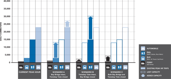
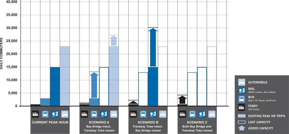
Commuters from the East Bay rely on BART, buses, private automobiles and ferries to get into downtown San Francisco every morning. These graphs show transit demand during peak-hour travel (from 7:30 to 8:30 a.m.). What happens to that demand if one or more transit links are unavailable? The outlined boxes in the graphs below represent lost capacity that has to be accommodated elsewhere. The arrows show how much capacity could be added to each mode if the steps recommended in this report are taken.
| Action item | Responsible agencies |
|---|---|
| Before the Disaster: Planning | |
| Create a plan to coordinate bus bridges across the Bay Bridge in the event BART service is disrupted. Such a plan would include routing, stops and schedules of new bus lines created for an emergency event. | AC Transit, BART and Caltrans |
| Create permanent bus-only lanes on approaching freeways to the Bay Bridge (I-80, I-580 and I-880). Consider contraflow lanes on these freeways, in addition to the Bay Bridge. | Caltrans and AC Transit |
| Develop a restricted vehicle plan. Identify the locations of the HOV system where occupancy limits would be increased, along with pre-designation of dedicated bus access ramps on the freeway and bridge access system. Pre-printed signs should be fabricated and stored. | Caltrans |
| Develop contraflow bus system, including a morning-only westbound contraflow lane to improve bus access into San Francisco. This system would be vital during a BART emergency. | Caltrans, MTC, and the Bay Area Toll Authority |
| Identify emergency park-and-ride locations, and have maps and draft websites available for their dissemination. | MTC and local government |
| Develop emergency transit plans. Agencies should develop plans for Bay Bridge failure which assign trains and buses to their most productive use. Plans should be coordinated across agencies. | MTC, BART and AC Transit |
| Establish an emergency reserve fleet. About 100 buses should be maintained in the East Bay. | AC Transit |
| Establish mutual aid agreements with other bus agencies. The Bay Area should enter into mutual aid agreements with other agencies to ensure that 100 buses can be quickly requisitioned, along with drivers from other operators. | AC Transit, MTC |
| Complete BART system improvements. BART is pursuing several capital improvement projects that would be of benefit after a disaster since they increase capacity within the system core. These include three-door cars that allow passengers to board faster and reduce the time trains spend in the stations. In addition, BART should begin the process of adding side platforms at critical center platform stations, such as Embarcadero and Montgomery. | BART |
| Ensure ferry vessel/terminal compatibility. Compile and maintain a register of existing and potential emergency ferry terminals, their characteristics and the requirements for vessels that would serve them after an emergency. | Water Emergency Transportation Authority |
| Identify critical docks and piers throughout the Bay Area that could be used after an earthquake. Develop a plan to create the necessary contingency infrastructure and procedures. | WETA |
| Develop a strategy for critical goods movement in both the response and recovery periods to ensure that food, water and construction materials can be delivered as required. | WETA |
| After the Disaster: Managing the Mid-Term | |
| Implement Bay Bridge restricted vehicle plan | Caltrans, MTC |
| Implement bus bridging in the event of a BART shutdown. Bus bridging uses buses to fill in a gap in rail service or highway facilities. As an example, if BART has a disabled train at Lake Merritt, buses can be used to transfer passengers between Fruitvale and 12th Street. | BART, AC Transit |
| Create contraflow bus lanes on Bay Bridge | Caltrans, AC Transit, MTC |
| Create bus only lanes on Bay Bridge and on approaching freeways. | Caltrans, AC Transit, MTC |
| Require all BART cars running into and out of San Francisco to be at full capacity—this would require significant management of the BART platforms at strategic locations. | BART |
| Implement mutual aid actions | MTC, AC Transit |
| Utilize excursion boats to enhance ferry service. | WETA |
| Ongoing (Long-term): Projects that create redundancy | |
| A second transbay tube would create a critical redundancy in the rail network between Oakland and San Francisco. Although this project would take years of planning and require a major financial investment, it would also ensure the region's economic viability in the event of a disaster. In addition, Caltrain and high-speed rail should be extended under the Bay to Oakland. A new tunnel would be built to current seismic standards, and it would provide increased capacity to the transportation system. | BART to lead, in consultation with Muni, AC Transit and cities that would receive new BART service. |
| Source: SPUR analysis | |
South Bay
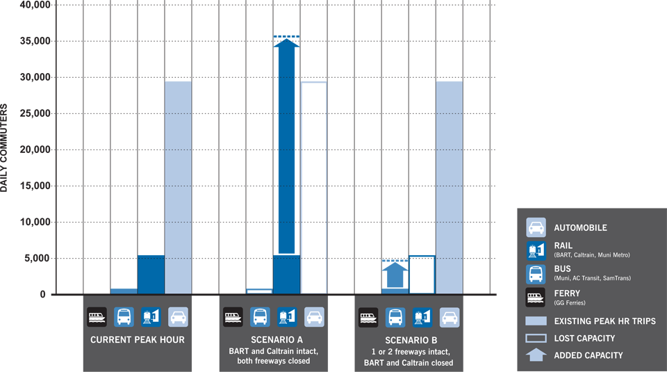
Of the corridors serving San Francisco, the South Bay has the greatest redundancy. Because there are multiple links from the South Bay to San Francisco, if one or two of the links are disrupted, there are other links that can compensate. The key freeway links between San Francisco and the South Bay are Highway 101 and Interstate 280. Caltrain and BART rail lines provide important transit links. There are also several major street connections: Bayshore Boulevard, Geneva Avenue, Mission Street, Junipero Serra Boulevard, Lake Merced Boulevard and Skyline Boulevard.
Caltrain and BART intact, both freeways closed
Under this scenario, neither Highway 101 nor I-280 would be able to provide access into San Francisco from south of the city. The current demand of about 330,000 daily car trips (192,000 for Highway 101 and 138,000 for I-280), accounting for an estimated 390,000 commuters, could not simply transfer to Caltrain, BART or bus service. About 29,200 of those car trips occur during peak hour. In addition there are about 800 people who commute daily by bus.
About two-thirds of peak-hour car trips and all bus passenger trips could be accom-modated by BART and Caltrain, adding about 20,700 additional rail passengers per hour.
If one or both freeways to the South Bay were disrupted, then many southbound commuters could be encouraged to use street highways, such as El Camino Real, Alemany Boulevard and Bayshore Boulevard. BART and Caltrain could increase their capacity by adding train cars, and by Caltrain adding express trains to and from San Francisco while also offering a limited express train route between San Mateo and San Jose. Bus service would need to be added to and from these "Baby Bullet" stations, and cities could augment the system by providing temporary park-and-ride stations with connecting buses. Finally, HOV lanes on open sections of Highway 101 and I-280 should be restricted to cars carrying a minimum of four people.
One or both freeways remain intact, BART and Caltrain closed

Under this scenario, neither Caltrain nor BART would be able to run northbound trains into San Francisco. This would affect about 40,000 BART and about 15,000 Caltrain trips into and out of San Francisco.
About 3,100 BART and 2,300 Caltrain trips occur during peak hour. About two-thirds of the total 5,500 peak-hour trips could be accommodated by regional buses, for a total of about 4,000 additional bus passengers per hour. The impact of rail-service disruptions could be mitigated through the addition of about 100 buses, park-and-ride locations in the South Bay and restricting HOV lanes for express buses and cars carrying a minimum of four passengers.
| Action item | Responsible agencies |
|---|---|
| Before the Disaster: Planning | |
| Establish plan for managing roadway capacity in the event of an emergency. Coordinate between agencies to plan for bus bridges and park-and-ride facilities. Create plans for emergency services in case of disaster, especially if freeways are disrupted. | BART, Caltrans |
| Strengthen and retrofit Caltrain tracks as necessary and tunnels on the peninsula and within San Francisco. | Caltrain |
| Develop a restricted vehicle plan. Identify the locations of the HOV system where occupancy limits would be increased, along with pre-designation of dedicated bus access ramps on the freeway and bridge access system. Pre-printed signs should be fabricated and stored. | Caltrans |
| Develop emergency park and ride locations. Identify various emergency park and ride locations and have maps and draft websites available for their dissemination. | MTC, local governments |
| Establish an emergency reserve bus fleet. Should BART and Caltrain fail, at least 100 additional buses would be required in Peninsula service. Build a reserve fleet of about 50 buses, located in San Mateo and northern Santa Clara Counties. Additionally, create a locomotive and passenger car fleet. Due to the higher cost of purchasing and storing rail cars, a very small fleet is recommended. | Caltrain, VTA |
| Enter into mutual aid agreements with other bus agencies to ensure that the other 50 buses required for service can be quickly requisitioned, along with drivers from other operators. In addition, agreements with rail providers (e.g. Amtrak, Metrolink, ACE) would ensure that additional rail cars could also be requisitioned quickly. | VTA, MTC |
| After the Disaster: Managing the Mid-Term | |
| Create bus bridges to manage roads with carpool lanes, bus prioritization and park-and-rides. | Caltrans, VTA |
| Allow for transit-only lanes on Highway 101 and I-280 | Caltrans |
| Employ old highway system, by making use of El Camino Real, Alemany and Bayshore. | Caltrans, MTC, local government |
| Require carpooling for private automobiles | Caltrans |
| Require Caltrain and BART cars to be full | Caltrain, BART |
| Use diesel locomotives on Caltrain lines if electricity is down. | Caltrain |
| Require valet parking at lots and garages. If existing parking facilities have assisted parking (aka valet parking), more cars can be parked. | Local Government |
| Ongoing (Long-term): Projects that create redundancy | |
| Complete the California high-speed rail project | CHSRA |
| Electrify Caltrain | Caltrain |
| Expand Caltrain to a four-track, completely grade-separated system | Caltrain |
| Source: SPUR analysis | |
North Bay
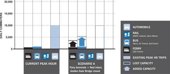
Although the Golden Gate Bridge and North Bay ferries accommodate only moderate traffic to San Francisco (relative to the Bay Bridge and BART), these links are just as vulnerable. With only one deck of six narrow lanes, the Golden Gate Bridge provides the only road access between the North Bay and San Francisco. There is currently no rail access from the North Bay to San Francisco. Only ferries, which are limited in their passenger capacity, provide another option.
Ferry terminals and fleet intact, Golden Gate Bridge closed
Under this scenario, we should plan for the Golden Gate Bridge's current demand of about 118,000 daily car trips (accommodating approximately 142,000 people). About 10,000 of these car trips occur during peak hour. An estimated 1,400 peak-hour bus passengers would also be affected.
All commuters would need to be diverted to ferries and the Richmond-San Rafael Bridge. About two-thirds of the 10,000 peak-hour trips could be accommodated by a combination of bus and ferry service, which could be increased by 6,700 passengers per hour.
Golden Gate Ferry services typically carry 3,500 passengers per day, and Vallejo Baylink 1,500 per day. In an emergency, Golden Gate Ferry could carry about 2,300 passengers per hour and Vallejo Baylink could carry about 600 passengers per hour, for a total of 2,900 passengers per hour for the North Bay corridor.
The Golden Gate Bridge, Highway and Transportation District will need to allocate its existing bus and ferry resources effectively. The agency would need to deploy 150 additional buses to deliver passengers to the El Cerrito Del Norte and Richmond BART stations. If the Bay Bridge were open, some buses could take the full journey to San Francisco, although such a route would require more buses due to the longer trip time.
The Richmond-San Rafael Bridge, and HOV lanes on Highway 101, I-580 and I-80, should be restricted to cars carrying a minimum of four people, and shoulder lanes could be used for express buses. Cities in Marin and Sonoma counties would need to provide additional park-and-ride locations to connect passengers to express bus stops.
| Action item | Responsible agencies |
|---|---|
| Before the Disaster: Planning | |
| Develop a restricted vehicle plan. Identify the locations of the HOV system where occupancy limits would be increased and identify locations that could be designated dedicated bus access ramps on the freeway and bridge access system. Signs should be fabricated and stored. | Caltrans |
| Develop emergency park-and-ride locations. Identify various emergency park-and-ride locations and have maps and draft websites available for their dissemination. | MTC, local governments |
| Establish an emergency reserve fleet. Should the Golden Gate Bridge fail, at least 150 additional buses would be required in service (due to using the Richmond Bridge and additional feeder services to the Larkspur Ferry). This will require several acres of parking, probably by expanding existing Golden Gate Transit bus yards in Marin. | Golden Gate Transit |
| Establish mutual aid agreements with other bus agencies. Enter into mutual aid agreements with other agencies to ensure that the additional buses required for service can be quickly requisitioned, along with drivers from other operators. | Golden Gate Transit, MTC |
| Develop a contraflow bus system. Caltrans, along with the Metropolitan Transportation Commission and the Bay Area Toll Authority, should develop emergency-only Bay Bridge and Richmond-San Rafael contraflow lanes to improve bus access after a disaster in the event that access across the Golden Gate Bridge is disrupted. | MTC, BATA |
| Develop emergency transit plans for Golden Gate Transit and Golden Gate Ferry, as well as BART. Each agency should develop a plan that assumes Golden Gate Bridge failure and assigns ferries and buses to their most productive use. Plans should be coordinated across agencies. | Golden Gate Transit, WETA, BART |
| Create a plan to coordinate bus bridges from Marin to San Francisco across the Richmond-San Rafael Bridge to East Bay BART stations or into San Francisco via the Bay Bridge. Such plans would include routing, stops and schedules of rerouted Golden Gate Bridge bus lines created for an emergency event. | Golden Gate Transit, MTC |
| After the Disaster: Managing the Mid-Term | |
| Require carpooling for private vehicles on the Richmond-San Rafael Bridge. | Caltrans, MTC |
| Implement the bus bridge plan to East Bay BART stations, or into San Francisco via the Bay Bridge. | Golden Gate Transit, BART, Caltrans |
| Create contraflow bus lanes on both decks of the Richmond-San Rafael Bridge. | Caltrans, MTC |
| Increase ferry service through borrowing ferry vehicles from tour operations and ferry operators from the West Coast. | WETA |
| Ongoing (Long-term): Projects that create redundancy | |
| Add ferry landings in appropriate locations. | WETA, Local Ports |
| Coordinate Sonoma Marin Area Rail Transit train service to access Larkspur Landing. | SMART, WETA |
| Replace Doyle Drive in San Francisco to ensure that its approach to the Golden Gate Bridge functions after an earthquake. | San Francisco County Transportation Authority |
| Source: SPUR analysis | |
Ferries
What if all regional links to the North, East and South Bay are damaged and unusable, and ferries are the only option for travel into and out of San Francisco? This is by far a worst-case scenario, a frightening one to consider. While ferries alone cannot provide the transportation we need, there are some important things we can do to increase our regional ferry capacity.
Only ferries functioning
If most or all major rail and highway links are disrupted, especially from the East and North Bay, a major upgrade in ferry service would be required. All existing and possible temporary landings would be employed on all shores. We would need to:
- Radically increase ferry service (additional docks would be needed, particularly at the downtown San Francisco Ferry Building)
- Add new routes of service. Some options include Richmond, Benicia and Redwood City, to spread the passenger load to new docks along existing San Francisco to Oakland routes
- Reroute bus lines from rail and highway networks to new ferry landings
- Add non-Bay Area ferry boats
| Action item | Responsible agencies |
|---|---|
| Inventory existing ferry fleets, commercial fleets, and ferry fleets at nearby cities (Los Angeles, Seattle, and Vancouver), to assess whether each fleet would be able to adapt to current ferry landings. In the inventory, indicate a tier of different boat sizes and capacity. | WETA |
Establish official disaster mutual aid agreements with other ferry operators so that the other ferry providers would be ready to offer some of their ferries to relieve the city in case of a disaster. Nearby boat and ferry agencies should be contacted first. Because some ferries may be seaworthy, cities at greater distances that would require an ocean journey for the ferry to reach the Bay Area also should be considered, but using ferries from some of these cities would present additional challenges:
| WETA |
| Consider preparing docks and ferry landings that could accommodate larger vessels. Many of the San Francisco piers may be able to take a large ferry, including the cruise ship terminal. However, such landings may not exist on other, smaller properties. Consider funding the development of new terminals as long as further ferry fleet development is environmentally smart and economically viable. The Water Emergency Transportation Authority would be in charge. | WETA |
| Inventory existing Bay Area landings: boat landings at marinas, ports and ramps that could be easily adapted for ferries, should be researched and developed. Some landings could be adapted ahead of time, while others could be altered after a disaster to accommodate water taxis and larger ferry vehicles. | WETA |
| After the Disaster: Managing the Mid-Term | |
| Increase ferry service where necessary | Caltrans, VTA |
| Consider adding water taxi services where possible and economically viable. Ferry landings could be added at sites that may not normally be viable for regular ferry services but would be critical in a disaster. | Caltrans |
| Reroute bus services to ferry landings if many or most links are disrupted. Ferry landings will also need large parking lots nearby and shuttle service from the parking lots to the ferry landing. Such parking lots include shopping centers, racetracks, empty lots, parks and universities. | Caltrans, MTC, local government |
| Source: SPUR analysis | |
Intra San Francisco
There are many redundancies in San Francisco's bus and light rail network. The only critical link with no direct equivalent is the Market Street subway, which serves both BART and Muni Metro trains. Ensuring resiliency for Muni will also require a series of capital investments, including retrofitting Muni stations not owned by BART and replacing Muni's central control facility.
Market street subway closed
Under this scenario, Muni's current demand of about 75,000 daily Market Street subway trips would need to be diverted to other modes. About 9,500 of those trips occur during peak hour. About two-thirds of the 9,500, or 6,300, could be accommodated by buses during peak-hour travel. If either the Twin Peaks or Sunset tunnel were compromised in addition to the Market Street subway, all light rail service would be converted to bus service. If only the Market Street subway were compromised then most, if not all, underground Muni service could move to the surface of Market Street. The City would also need to deploy 250 additional buses, and should consider closing Market Street off to cars in the event of a disaster. If electric buses and roads are incapacitated, a functioning BART could increase service along the downtown corridor of Market Street. The City should also consider a plan to deploy diesel buses if Muni's electrical system fails.
| Action item | Responsible agencies |
|---|---|
| Before the Disaster: Planning | |
| Complete a performance audit of Muni facilities (yards, stations) and identify deficiencies and retrofit as required. Ensure that facilities will be operable within two days. | MTA |
| Replace Muni's central control facility, ensuring that it performs as an essential facility. | MTA |
| Retrofit Forest Hills Muni Metro station | MTA |
| Develop a plan for deploying diesel and hybrid buses on incapacitated electric bus routes. Make routes with the highest ridership the highest priority. | MTA |
| Enact mutual aid agreements for buses and bus service with other transit agencies. | MTA |
| Develop program and stockpile materials to allow Muni Metro light rail vehicles to operate on the surface if the Market Street subway tunnel is damaged. | MTA |
| Establish an emergency reserve fleet. Should Muni's electrical transit system fail, at least 200 additional buses would be required to partially compensate for the almost 400 trolley coaches and nearly 200 light-rail vehicles. While Muni has maintained a small reserve fleet for minor events, it is not sufficient. On the other hand, it would be unwise to simply store 200 old buses for possible use. They need to be maintained, occasionally cleaned and garaged. However, in conjunction with other reserve fleets (such as the East Bay fleet) Muni should maintain a reserve fleet of about 100 buses, located in San Francisco. This will require a total of about three acres of parking, which could require the expansion of an existing or planned Muni diesel yard. | MTA |
| Plan for bicycle transportation as part of the immediate, medium and long-term recovery period. | MTA |
| After the Disaster: Managing the Mid-Term | |
| Activate reserve fleet as necessary. | MTA |
| Deploy diesel buses on incapacitated electric bus routes. | MTA |
| Run Muni light rail vehicles on Market Street surface—likely would require temporary retrofit of LRVs with trolley poles. | MTA |
| Create temporary transit-only streets to allow for more high volume usage. | MTA |
| Ensure that the bicycle network is usable during recovery period and that the network is enhanced and expanded as part of long-term recovery. | MTA |
| Ongoing (Long-term): Projects that create redundancy | |
| Build San Francisco's Bus Rapid Transit network, including Bus Rapid Transit lines on Geary and Van Ness. | SFCTA, MTA |
| Complete Transbay Terminal | Transbay Joint Powers Authority |
| Build out the bicycle network | MTA |
| Build a new BART line serving San Francisco to ensure redundancy after a disaster. | BART |
Additional Recommendations
SPUR has three recommendations not specific to any corridor that would enable San Francisco and its associated transportation systems to recover quickly and effectively from a disaster.
Recommendation #1: Determine which agencies should lead the recovery of transportation systems after a disaster.
No single entity, task force or organization in the San Francisco Bay Area is responsible for the region's recovery after a disaster. The Metropolitan Transportation Commission, in coordination with the Association of Bay Area Governments, needs to assess the need for the creation a transportation recovery entity that will function as the Bay Area's command center for transportation. Specifically, the MTC should determine what powers a regional recovery organization would need to facilitate coordination among the various transit operators and to help balance competing priorities. The MTC should conduct this analysis through its Transit Sustainability program.
In the short term, ABAG and the MTC should convene a group of high-level public and private stakeholders to focus specifically on transportation recovery planning. This group should define plans and criteria for recovery before an event, and may be positioned to begin recovery very soon after the event. The group should study and form plans to take action in a number of key areas:
- Organizational form, structure, roles and responsibilities of a recovery authority after a catastrophe
- Criteria and processes for transition from response to recovery
- Criteria for determining and setting priorities for investments in restoration, removal or improved rebuilding of damaged transportation facilities
- Features, facilities and services that are preferred for investment in restoration or rebuilding differently
- Desirable alternative states of transportation infrastructure, service and administration
- Reconfiguration of transportation infrastructure in response to observed damage after earthquake
- Compiling knowledge of best practices throughout the world for recovery and restoration of transportation systems
In addition to defining the criteria and processes for restoring and rebuilding transportation infrastructure, this group could also develop scenarios assuming various types, distributions and levels of severity of catastrophic events, and could use these scenarios as case studies for planning and executing the recovery and rebuilding of transportation systems.
Recommendation #2: Complete a performance audit of our existing transportation infrastructure.
SPUR's work on lifelines as part of its Before the Disaster efforts revealed that, for the most part, we don't know how our lifelines will perform during a disaster. We recommended that a lifelines audit be conducted, using the performance during both the "expected" and the "extreme" earthquakes as standards. Information on the extreme event is needed for immediate response planning, and information on performance under the expected event is needed for non-critical transportation infrastructure that will be required during the recovery phase. This recommendation should be extended to the Bay Area's transportation systems. The MTC should assess the performance of our existing transportation infrastructure, and report its findings within a year.
After a disaster, bikes can help
After a disaster, bicycles can offer efficient transportation alternatives when other options may be unavailable. Bicycles can be used by engineers and inspectors performing building triage for tagging damaged buildings and transportation infrastructure, for personal use by residents for commuting, and as an option for evacuation post-earthquake, given the likely limited road and rail alternatives available to the nearly one million people in the city during a peak period in the day.

Recommendation #3: Engage in hazard mitigation strategies to shore up our existing transit infrastructure and add redundancy on core transportation lines.
Some links are more important than others. Some links carry more traffic, or have more capacity, or have a higher risk of failing in an earthquake. How should we determine which projects are the most important to complete now—before the disaster—to help facilitate a rapid recovery after the disaster? SPUR believes that several hazard mitigation strategies are the most important to pursue:
- Complete ongoing or planned retrofits of regional systems, including Bay crossings, other freeway bridges and important links (e.g. the replacement of Doyle Drive), and the BART retrofit program
- Retrofit existing piers that are or can be used for ferry landings, and establish additional ferry landing sites
- Increase the resilience of fuel storage and distribution systems to promote rapid restoration of the fuel supply for transit providers, businesses and commuters
- Increase the resilience of facilities that support mass transportation (such as power supplies and maintenance facilities)
Conclusion
The recommendations in this report are by no means exhaustive. There is still much work to be done to prepare to recover from a major earthquake. By planning now, we can increase the likelihood of being able to rebuild both quickly and effectively. It's this type of foresight and planning that will make our city and region truly resilient.
Endnotes
- Metropolitan Transportation Commission, San Francisco Central Business District Analysis, "Table 1: Total Employment in Downtown San Francisco 1980-2035 based on ABAG Projections 2000, 2005, 2007", June 2007
- "Caltrain Downtown Extension and Transbay Ridership Analysis" prepared by Cambridge Systematics, Inc. for the Transbay Joint Powers Authority. Final Report, November 2008 and "Transbay Ridership Analysis: Draft Report" prepared for Alameda-Contra Costa Transit, Transbay Joint Powers Authority, Metropolitan Transportation Commission, San Francisco Water Transit Authority, August 2007. Data derived from both draft and final reports and analyzed in SPUR's "Future of Downtown" Report, January 2009, page 34. Additional analysis prepared by Cambridge Systematics, Inc and Arup.