
The Maeslantkering, the largest storm surge barrier in the world, is located on the west coast of The Netherlands and closes automatically when the seas rise with a storm. [Image: Aero Lin Photo]
The Maeslantkering, the largest storm surge barrier in the world, is located on the west coast of The Netherlands and closes automatically when the seas rise with a storm. [Image: Aero Lin Photo]
This article is a supplement to Sea Level Rise and the Future of the Bay Area
What it is: A large dam, gate, or lock — or a series of them — that manages tidal flows in and out of San Francisco Bay.
This strategy could be used at the Golden Gate, or in smaller, strategic parts of the Bay that are somewhat enclosed to begin with. The barrier could be fixed in place and allow managed flow through a portal for water exchange, tidal function and navigation. Alternatively, it could be temporarily deployed just to head off the worst flooding during a storm surge.
Examples
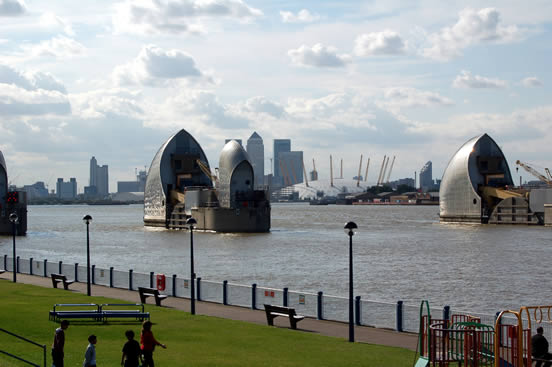 The Thames Barrier is located downstream of central London. [Image: flickr user Miscal Photo Man]
Advantages
Barriers could protect a large area of land in a single sweep. A single, technological fix, particularly if it is at the Golden Gate, protects a huge area of land from flooding with one project.
Barriers also protect everyone, and therefore have no social equity issues that might follow a more piecemeal or land use-based strategy in which some places would get protected and others would need to be abandoned.
Disadvantages
Barriers are expensive to construct. The Maeslant Barrier was estimated to cost $4 billion, and the famous Three Gorges Dam in China is expected to cost $25 billion when complete. In 2007, the Bay Conservation and Development Commission studied the idea of constructing a tidal barrage, or complete obstruction of the waterway, at the Golden Gate.1The BCDC reported that it is likely that a Golden Gate barrage would be double or triple the cost of a similar structure in China. Moreover, a barrage would be a far more expensive protection strategy for the Bay than building levees and reconstructing infrastructure.
Barriers are also ecologically damaging. The BCDC's study also found that a barrier would affect the Bay's salinity, sedimentation, wetlands, wildlife and endangered species. It also would affect sedimentation, likely making parts of the Bay shallower, while increasing coastal erosion.
Unknowns
Barriers may not work. A barrier that holds back ocean storm surges is not likely to simultaneously function well in the other direction, causing upstream flooding in the freshwater tributaries of the Bay.
What it is: Linear protection, such as levees and seawalls, that fix the shoreline in its current place.
Linear protection is today's most widely used tool for protecting both development and wetlands in the Bay and the confluence of the Bay and the Sacramento-San Joaquin Delta, as well as along the ocean coastline. It takes different forms depending on the kind of coastline needing protection. The most hardened form, engineered concrete seawalls and bulkheads, protects the shore from strong wave action. Earthen levees protect low-lying land, often from river flooding, and come in many forms. They also can be raised with sand bags in an emergency. A softer approach, used to protect non-hardened shorelines, is beach nourishment: adding sand to maintain and restore eroding beaches, including building or enlarging sand dunes. Other beach protection strategies include offshore breakwaters, built parallel to the shore to reduce waves, and groins, which are perpendicular "riprap" — walls of rocks or interlocking concrete forms spanning the beach to a hundred feet offshore to prevent erosion
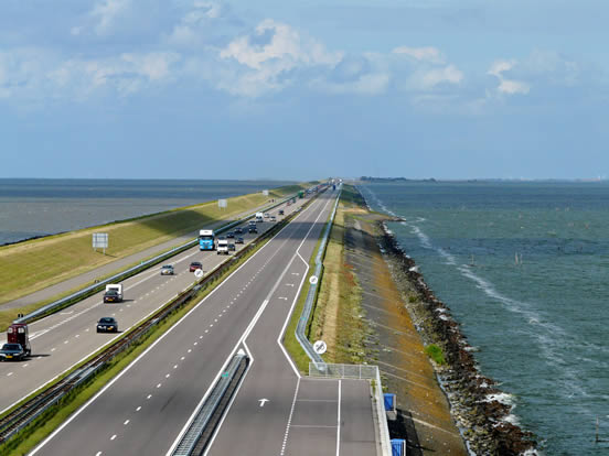
Motorway Dike in The Netherlands. [Image: picasa user Wilfrid]
Examples
Advantages
Armoring is our oldest flood protection tool. It's familiar, behaves predictably and can be used in combination with other strategies to protect existing development from rising water. It can be used against both storm surge and baseline sea level rise. It also can be designed to accommodate new development such as housing along super levees, or protect threatened habitat such as sand dunes.
Disadvantages
It's a short-term solution. All coastal armoring can be engineered only to accommodate a certain storm size or rise in sea level. It also requires costly annual maintenance and regular monitoring to ensure it remains safe. An unusually large storm event can also cause it to rupture like the levees in New Orleans during Hurricane Katrina, even if it has been well maintained.
Paradoxically, it increases vulnerability. Hard shoreline protection is not as effective as natural shorelines at dissipating the energy from waves and tides. As a result, armored shorelines tend to be more vulnerable to erosion, and to increase erosion of nearby beaches. Structural flood protection can also increase human vulnerability by giving people a false sense of security and encouraging development in areas that are vulnerable to flooding.2
What it is: raising the height of land or existing development and protecting it with coastal armoring.
Much of today's Bay shoreline was formed by reclamation, a practice conducted by private land owners and municipalities alike, starting in the Gold Rush. Although more than 200 square miles of land was filled in the Bay, it was almost entirely stopped after the formation of BCDC in 1965. The elevation of much of this reclaimed land is barely above sea level; ironically, maps of projected sea level rise in 2100 look a lot like maps of the Bay from 1849.
Although further filling the Bay for new development to be protected by new levees is not likely to be popular in California, new fill is a strategy being used by the Netherlands to both expand and elevate land for settlement. Here, our options would more likely be confined to elevating existing fill land and protecting it with armoring. We could also use elevation to protect infrastructure such as airports, roads or railways.
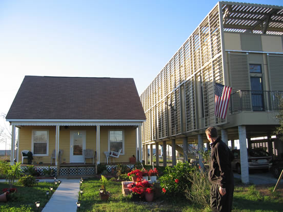 Old and new. At right, an elevated house in New Orleans by Kieran Timberlake for the Make it Right Foundation. [Image: flickr user werdsnave]
Examples
Advantages
This strategy allows structures to be built upon an encroaching shoreline or in a vulnerable area, with a low risk of flooding. Although it is probably only cost-effective for new buildings, it may be a good tool for retrofitting certain low-lying infrastructure, such as airports.
Disadvantages
But it's also a short-term strategy. Elevated development, unless on stilts directly over water, also alters the characteristics of shorelines and will need protection just like low-lying development. Its advantage is merely that it is not threatened by sea level rise for a longer time.
Unknowns
We don't know if higher land or structures will support high-density, transit-oriented new development. Much of our region's high-density neighborhoods and transit are near the Bay's shoreline. Elevated new development in these areas, particularly if constructed near existing transit or built densely enough to fund the creation of new transit — like the plan for Treasure Island — could be a good strategy to accommodate growth without worsening sprawl. However, if low-density development is allowed to proceed along the shoreline, it could increase global warming emissions, and may not warrant expensive protection measures in the future.
What it is: Structures that float on the surface of the water, or may be floated occasionally during a flood, making them largely invulnerable to changing tides.
Floating homes can be moored to the shore or anchored to the sea floor. Floating development differs from boats in that it lacks propulsion systems. The challenge of sea level rise has spurred designs for floating much larger forms of development than single-family homes, such as an offshore airport in the Netherlands' North Sea, and floating hotels and restaurants off of Dubai. Electricity, water and wastewater infrastructure must be supplied to floating development through flexible pipes.
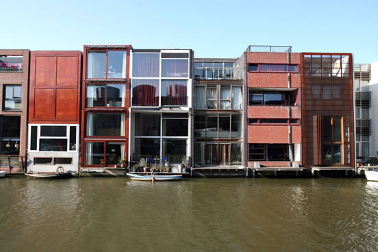 Multi-family floating canal houses on Scheepstimmermanstraat, Amsterdam. [Image: flickr user stevecadman
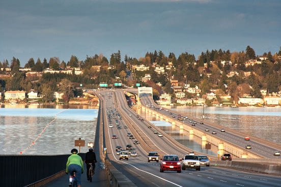
I-90 floating bridge on Lake Washington in Seattle. [Image: JP Cumberland]
Examples
Advantages
Floating development manages the uncertainty of high tides and earthquakes. Floating development could work in spite of the uncertainty surrounding the timing and nature of sea level rise. Floating development is very resilient to seismic activity.
Disadvantages
Floating development works only in protected areas. Floating structures do not work well in places subject to wind and wave action from storms, such as the ocean coastline.
Unknowns
This type of development has not yet been demonstrated in high-density cities. Floating development is just beginning to be thought of as a sea level rise strategy for larger cities or islands. From an engineering perspective, many structures can be built to float, though they cannot be retrofitted to do so. As they have not been demonstrated anywhere as a model for high density cities, floating developments could end up — like badly designed elevated development — facilitating growth in parts of the Bay Area that are not close to jobs, transit and services.
What it is: Structures that are designed to withstand flooding or to retain stormwater.
The idea of floodable development is two-pronged. One idea is to design buildings and infrastructure to resist damage by occasional or even periodic flooding. This could also be a back-up strategy in case shoreline armoring fails. A second idea is to create retention areas for ocean surges or heavy rainfall. Here water would be captured, and then later released to receiving waters, or to the wastewater system, when flood waters recede. Floodable development is an extreme form of "low impact development," (LID) a set of tools for beneficially reusing stormwater by infiltrating it into the ground, creating green space and habitat while reducing the demands on urban wastewater treatment systems. New floodable development built to handle sea level rise may be designed to manage stormwater, both salt and fresh, at orders of magnitude above most LID tools.
Examples
Advantages
Floodable development could take an effective small-scale toolbox to the next level. It may best be thought of as a suite of tools (including LID) that can be selected based on which work best at a given site. But unlike LID, the floodable development suite of tools is still experimental. Some tools may be better for fresh water or salt water, or a mix; some may be better in urban areas versus agricultural or rural areas.
Disadvantages
Floodable development could be hazardous. Stormwater, particularly at the seaward end of a watershed, is usually polluted with heavy metals and organic chemicals, in addition to sediment and bacteria. Large quantities of stormwater sitting on the surface, or in underground storage facilities, could pose a public health hazard during a flood or leave contamination behind. This could be a particular problem in areas with combined sewer systems, such as San Francisco, where wastewater and street runoff go to the same treatment system. Also, wastewater treatment systems that commonly treat the hazards of combined sewer effluent before releasing it into the Bay do not work well with salt water mixed in. If floodable development strategies are designed to hold and release brackish water, new treatment methods will be needed for the released water to meet water quality standards. Finally, emergency communication tools and extensive public outreach and management would be required to prevent people from misusing or getting trapped in flooding zones.
Unknowns
Floodable development is untested. We don't know if buildings and infrastructure can be designed or retrofitted to accommodate occasional flooding in a cost-effective way.
It is not clear exactly how much volume new floodable development tools will hold. Some of the more heavily engineered solutions, such as a water-holding parking garage, may not turn out to be more beneficial than armoring or investments in upsizing an existing wastewater system.
What it is: Wetlands are the natural form of our shoreline. They absorb floods, slow erosion and provide habitat.
Living shorelines or wetlands are essential for the health of estuaries. They protect shorelines from floods and erosion by absorbing waves, and slowing the flow of high water. Wetlands take various forms, depending on the characteristics of their surrounding waterways. Our region is home to wetlands that include tidal basins, marshes, mud flats, rocky shores, and pebble beaches.
Tidal marshes are the natural form of most of the Bay shoreline, but their realm has been reduced to about 5 percent of their historic extent due to filling, armoring and reclamation activities. Still, that 5 percent accounts for more than 90 percent of California's remaining tidal wetlands. A broad, scientific assessment 10 years ago found that a healthy Bay required at least 100,000 acres of tidal wetlands.3 At the time, there were about 40,000 acres. Since then, about 33,000 acres have been purchased by public agencies and private land trusts for the purpose of tidal wetland restoration.4
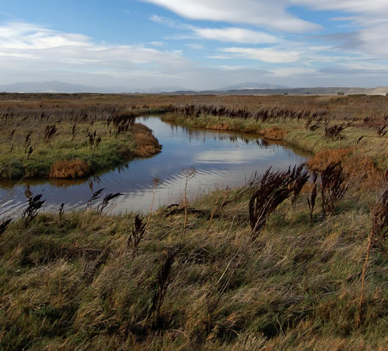
Suisun Marsh wetlands in the north of San Francisco Bay. [Image: Matt Knoth]
Examples
Although smaller patches of wetlands dot the San Francisco Bay shoreline in every county, large tracts exist in the most northern and southern parts. The North Bay wetlands include the Richardson Bay and Sonoma wetlands, the San Pablo Bay National Wildlife Refuge and the Suisun Marsh. Major wetlands and restoration projects in the South and East Bay include the Don Edwards Wildlife Refuge in Redwood City and the South Bay Salt Pond Restoration Project, the largest tidal wetland restoration project on the West Coast.
Advantages
Living shorelines benefit society. Wetlands filter pollutants out of water, sequester carbon, provide recreational open space, and create critical habitat for fish, wildlife and millions of organisms that live in tidal mud and are the basis of aquatic food chains.
Disadvantages
Living shorelines require space and time to work. Wetlands are generally "thicker" than linear armoring strategies such as levees, so they need more land. They also require management, monitoring and time to become established.
Unknowns
Living shorelines are naturally adaptive to sea level rise, as long as two conditions are present. The first condition required for an adaptive living shoreline is that it must have space to migrate landward. The second condition is that they must be sufficiently supplied with sediment to be able to "keep up" with sea level rise. Due to the many dams and modified hydrology of the Delta and its major rivers, this is a concern for restoration success in San Francisco Bay.
Wetlands will never be restored to their historic extent along the Bay, in part because of the cost of moving development inland from urbanized areas at the water's edge. At the same time, reserving a buffer or setback area in which wetlands can form and migrate between developed places and today's shoreline could be a very cost-effective flood protection strategy. Important challenges for our region will be determining how much flooding new tidal marshes could attenuate, restoring them in appropriate places, and conducting restoration at a faster rate than we would without the looming threat of rising seas.
What it is: Managed retreat is the planned abandonment of threatened areas near the shoreline.
Managed retreat is a strategy that safely removes settlement from encroaching shorelines, allowing the water to advance unimpeded. It involves abandoning, demolishing or moving existing buildings and infrastructure to higher ground. It also includes banning new development in areas likely to be inundated. It is used when coastal armoring and other shoreline protection efforts become very expensive or are judged to be a losing battle. The "managed" part of retreating from the shoreline involves establishing thresholds to trigger activities such as demolishing buildings or abandoning efforts to control shoreline erosion. These thresholds can be coupled with buy-back programs to compensate property owners for loss, plus strict building codes that allow only certain types of relocatable or floodable structures.
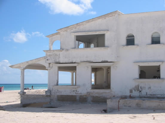
An abandoned beach house awaits demolition. [Image: flicrk user swirlspace]
Examples
Advantages
Managed retreat minimizes human suffering, by relocating buildings and infrastructure to safer ground before a catastrophic flood.
Managed retreat usually is less expensive than armoring strategies, especially when structural measures can only be temporary. It also can be designed to allow the restoration of flood-buffering wetlands and natural shoreline habitat, which affords protection.
However, managed retreat potentially can be very expensive for areas that are significantly developed, and it will cause a loss of coastal property values if setback lines are moved. It is a measure of last resort for many highly developed coastal areas that have no places for buildings to be relocated.
Disadvantages
This strategy is a political quagmire. It involves tremendous legal and equity issues, because not all property owners are willing sellers. And in many places, shoreline communities are already disadvantaged and lack the adaptive capacity to relocate. In addition, retreat may require costs beyond relocation or property costs if site cleanup — such as to remove toxics — is needed following demolition.
1 Kirstin Conti, Will Travis, and Brenda Goeden, "Analysis of a Tidal Barrage at the Golden Gate," BCDC, Nov. 20, 2007.
2 Matthew Heberger, the Pacific Institute, et al., "The Impacts of Sea-Level Rise on the California Coast," California Climate Change Center, May 2009.
3 San Francisco Bay Area Wetlands Ecosystem Goals Project, "Baylands Ecosystem Habitat Goals," 1999.
4 According to Save the Bay.