Big transportation projects have been known for making neighborhoods worse, not better, with highways and train tracks slicing up communities. So when a new highway, rail line or tunnel is planned, how can a city best respond?
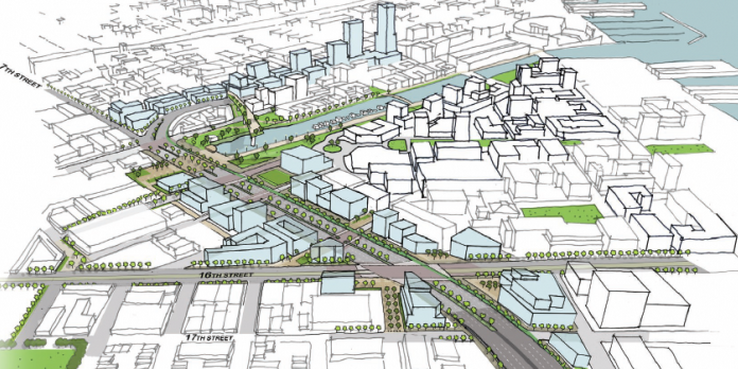
A few billion dollars of transportation projects are converging in San Francisco: the electrification of the Caltrain system, the extension of Caltrain’s route to the Transbay Transit Center (known as the Downtown Rail Extension or DTX) and the arrival of high-speed rail (HSR). How can these transportation investments improve San Francisco's urban environment rather than disrupt it? To find out, the San Francisco Planning Department is launching a major study, the Railyard Alternatives and I-280 Boulevard Feasibility Study. The study area is bounded by Market Street to the north, the bay to the east, 18th Street to the south and Bryant/8th Street to the west.
The $1.45 million feasibility study aims to “build a future that is more than the sum of its parts” and “undo planning missteps of the past.” This means improving circulation for transit, cars, pedestrians and cyclists; growing transit-oriented jobs and housing in a prime location; unlocking economic value by improving the neighborhood environment; and increasing connectivity between SoMa, Potrero Hill, Showplace Square and Mission Bay.
The study will apply rigorous analysis to the bold ideas presented in SPUR’s 2013 report Taking Down a Freeway to Reconnect a Neighborhood. It also builds on the SF Planning Department's 2012 report Fourth and King Street Railyards: Opportunities and Constraints, funded by the San Francisco County Transportation Authority.
Phase I of the study will take on five interrelated analyses to develop a neighborhood vision for the area and reconceive the transportation projects to fulfill this vision:
1. Evaluate making I-280 into a boulevard. Last week, the Congress for New Urbanism named I-280 in San Francisco one of their “Freeways with no Future.” The study would determine the impacts and benefits associated with replacing the stub end of I-280 with an urban surface boulevard as far south as Mariposa Street. This boulevard could provide transit, walking, cycling and driving connections from SoMa, Potrero Hill, and Showplace Square to Mission Bay, which is currently separated by 1.2 miles of I-280. It could also facilitate 16th Street bus rapid transit service.
2. Value engineer the HSR/DTX alignment. Construction of the DTX, which would connect high-speed rail and Caltrain to the Transbay Transit Center, is not yet funded. However, significant planning and environmental clearance of this project has been completed. The planned DTX tunnel is very expensive (cost will depend on the contract method chosen; current estimates are $2.5 billion or more for 1.3 miles) due to the construction methods (cut-and-cover combined with sequential mined excavation). A tunnel boring machine like the one being used for the Central Subway could reduce costs, but this could require altering the number of tracks entering the Transbay Transit Center. This analysis will review earlier construction methods and rail configurations and seek opportunities to fund and build the project sooner and more cost effectively.
3. Consider a loop track. Right now, the Caltrain and HSR tracks would dead end at the Transbay Transit Center, requiring trains to back out, which can conflict with inbound trains and constrain capacity. A loop track could facilitate return train trips southbound and eventually connect to the East Bay in a second transbay tube. However, extending the tracks in a loop could be constrained by existing and planned buildings. The study would assess the technical and financial benefits and costs of including a loop track in the area.
4. Evaluate consolidation or relocation of the 4th and King railyard. The study will evaluate the options for consolidating and/or relocating part or all of the Caltrain railyards at 4th and King. These railyards are used for Caltrain train storage and minor maintenance — functions that are being modified as part of the electrification project. Relocating the railyards would enable the redevelopment of parcels in the station area and reduce localized noise and air-quality impacts. The study will propose and evaluate up to six new potential locations or layouts; consolidation and/or relocation could take place in phases. Of all of the transportation projects, Caltrain electrification is furthest along and will finalize environmental clearance this year.
5. Identify placemaking and development opportunities. Boulevarding I-280 (4+ acres of land) and relocating the railyards (20+ acres) could open up many adjacent parcels between the growing Mission Bay, South of Market and Showplace Square neighborhoods. The opportunity has inspired the community. In 2013 the Center for Architecture + Design sponsored a competition (co-sponsored by SPUR) called What if 280 Came Down? Winners created concepts of what to do with the parcels freed up by boulevarding 280.The feasibility study will propose land use responses to the transportation projects and estimate both development capacity and how much value can be captured from this opportunity. Revenue could be allocated for Caltrain or other transportation improvements. The development should also lead to more riders for Caltrain, HSR and local transit.
Phase II of this study will narrow down the options to a handful of project alternatives and then select a preferred alternative.
From Ideas to Public Process
These ideas are exciting, but they may force difficult decisions, especially for the Transbay Joint Powers Authority, Caltrain and the California High Speed Rail Authority. Whether the existing projects should be altered, and how, will depend on a range of criteria, such as cost, ridership, sea level rise, economic opportunity and environmental review.
We have the opportunity to create one of the biggest and best transit-oriented communities on the West Coast. If we want big results, we may need to make some big moves.