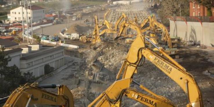
On the last weekend of April, as thousands watched, 40 giant pneumatic hammers pounded much of San Francisco’s Doyle Drive into recycled concrete and rebar. The following Monday morning, cars streamed across an elegant new viaduct over the Presidio’s Cavalry Valley and cruised through a new tunnel cut into the bluff between the San Francisco National Cemetery and the historic batteries that once guarded the Golden Gate from invasion.
After 22 years, a vision SPUR fought hard for was finally underway: the transformation of Doyle Drive from a clunky and dangerous artifact into a graceful entryway to the city. When the $1.1 billion project is completed in 2015, cars and traffic noise will no longer dominate many key landscapes of the Presidio national park.

The new tunnel separates traffic from the San Francisco National Cemetery. Photo by Michael Alexander
Getting big infrastructure projects built is hard enough, let alone when the project and its setting are fundamentally incompatible. As former vice-chair of the Doyle Drive Task Force and chair of SPUR’s Doyle Drive Committee, I had an intimate view of the planning process, the lessons SPUR learned about the priorities and beliefs of different agencies and organizations, and the need for SPUR to stay committed for the long haul.
Beginnings
1989 was not San Francisco’s best year. The Loma Prieta earthquake not only closed the Embarcadero Freeway but compromised the structural integrity of Doyle Drive, the roadway through the Presidio connecting the Golden Gate Bridge to the city street grid. In addition, the Army had announced that it would be marching out of the Presidio, its post at the headlands of the Golden Gate, leaving 1,400 spectacular acres, hundreds of historic buildings and millions of dollars of deferred maintenance to the National Park Service.
While these disruptions created stunning opportunities, the political, economic, organizational and design challenges were daunting. Doyle Drive was especially complicated. Constructed by the Golden Gate Bridge and Highway District in 1937, its design was compromised by Army demands that it not hinder military activities or provide public access to the post. From the bridge’s toll plaza it sprawled across the Golden Gate headlands, then narrowed to span the pretty Cavalry Valley and its beloved Pet Cemetery on a tall, bulky viaduct and noisily ran across a bluff a hundred feet from the front rank of headstones in the Presidio Cemetery. Its eastern portion was an ugly viaduct atop more than a hundred closely spaced piers, which allowed military trucks passing underneath to carry supplies between Crissy Field’s warehouses and the Presidio’s Main Post. Its six narrow lanes had no center barrier and no shoulders.

The old Doyle Drive viaducts used to block views of the Palace of Fine Arts as they traversed Crissy Field. Photo by Michael Alexander
Overlapping jurisdictions complicated things further. Doyle Drive was owned by the Golden Gate Bridge and Highway District and operated and maintained by Caltrans — on a right-of-way through a park run by the National Park Service and later by the Presidio Trust. To top it off, the road landed in the city’s Marina District, on Richardson Avenue and Marina Boulevard — whose residents militantly wanted traffic near their homes shifted to other families’ street.
San Francisco’s Board of Supervisors was the first to step into this jurisdictional morass and political quagmire, creating the Doyle Drive Task Force in the early 1990s to provide recommendations. Task force representatives of agencies, neighborhoods and community organizations like SPUR and the Sierra Club spent fruitless months mostly protecting their turfs as Caltrans presented a list of 26 (!) conceptual designs that sang to nobody.
The fundamental problem for most was that all the offerings were variations on the straightforward freeway built to modern standards: eight lanes, each 12 feet wide, plus shoulders, center barrier and massive off ramps — all of which would double the width of the existing road. Considering that this 1.6-mile road would connect the Golden Gate Bridge’s six narrow lanes primarily to Lombard Street’s six narrow lanes and Marina Boulevard’s four lanes, a freeway through a national park struck most as excessive. It could have been 20 lanes wide, and traffic would still be constricted at the necks.
But the highway engineers insisted, seldom mentioning but always aware that any variation from the standard highway manual could expose Caltrans to legal damages from accident claims. To be fair, they were also trying to respond to often-conflicting environmental, historic preservation and not-in-front-of-my-house demands.
The Breakthrough
Then, at the end of another meeting of re-re-restated positions (I recall once, in frustration, undiplomatically banging my forehead on the table), a local landscape architect and SPUR member, Michael Painter, asked to speak. But first he unrolled and taped to the wall a colored plan, nearly 20 feet long, of a very different concept. Here was a road that, at two critical points in the park, simply disappeared.
Alongside the cemetery, the road ran in a cut-and-cover tunnel with a landscaped top, so that people could once again walk to the historic battery bluffs. Traffic noise would no longer intrude on those visiting the resting places of the fallen. In front of the Main Post’s bluff edge, the road ran at grade but was covered by a 1,000-foot-long landscaped cap that reconnected Crissy Field with the rest of the park, allowing people to walk or bike over the hidden highway. From there to the park’s eastern end, a low viaduct would allow for expanding Crissy Field’s tidal lagoon and joining it to Tennessee Hollow Creek. A new turnoff would provide direct public access to the park.
For more than a year, task force representatives had proclaimed what we didn’t want. After 20 minutes, we finally knew what we did want, and it was Michael Painter’s plan — a roadway that had no choice but to traverse a national park yet was appropriate to its setting. I drafted the recommendations, and San Francisco’s Board of Supervisors adopted them.
The San Francisco County Transportation Authority (SFCTA), a small agency headed by José-Luis Moscovich, led the city’s interests. Moscovich had been involved with Caltrans’ plans from the beginning. One of his first tasks when he took the job was to go with SPUR to Caltrans’ offices in Oakland, where the state agency presented its 26 options. He left realizing that the multiple stakeholders would never be able to agree to any of them.
Caltrans, however, was not giving up. Its consultants, Parsons Brinkerhoff — a major international planning, engineering and program management firm — gradually narrowed the 26 designs to four. All had major problems meeting the conflicting demands of agencies, groups within agencies and stakeholders.
And the Painter plan? Caltrans and PB dismissed it as infeasible and too expensive.
I believe there was a subtext here. For infrastructure projects like roads, landscape architects are at the bottom of the professional pile. A common attitude is, We’ll build it, then give you a little money to pretty it up. The focus is on objects, while landscape architects focus on spaces. But it’s not as though Painter didn’t have street cred — literally. He was the designer of San Francisco’s Great Highway, with its protective planted dunes and flanking pedestrian and bicycle trails.
SPUR and Arup to the Rescue
SPUR disagreed with the experts’ conclusions, but the opinions of urbanists and planners on SPUR’s Presidio Task Force carried little weight with road builders and engineers. So we turned to one of our member firms, Arup. This firm of designers, planners and engineers is favored by many of the world’s leading architects and has worked on challenging road designs in sensitive areas across the globe. SPUR asked Arup to express its opinion of the feasibility and cost of Painter’s design.
Arup’s judgment: fewer impacts on the national park, better design and less costly.
This could not be ignored. Moscovich and the SFCTA insured that the Doyle Drive Draft Environmental Impact Statement would include the Painter plan along with the four PB alternatives and the required no-build alternative (which described what the next earthquake was likely to do to Doyle Drive, and to traffic throughout the Bay Area).
A major problem with rebuilding Doyle Drive was that traffic had to continue to flow. Close Doyle, and you might as well close the Golden Gate Bridge. The usual solution is to transfer traffic to a parallel temporary road, demolish the existing road, build the new one, transfer traffic to the new road, remove the temporary structure and restore the damaged surroundings.
At the Presidio, there often wasn’t enough width to allow this, although most of the plans called for it. Painter — whose style is to constantly, even obsessively, refine his designs — developed a novel alternative: build half the width of the new road, transfer traffic to it, then demolish the old road and build the other half of the new road in the footprint of the old. This would save hundreds of millions of dollars and years of work. It proved feasible for the narrowest, most critical parts of the project.
In the end, the Painter plan proved so superior that the four Caltrans/PB alternatives were dropped. Each would have cost about $3 billion. Today the new Presidio Parkway is on schedule and on budget at $1.1 billion.
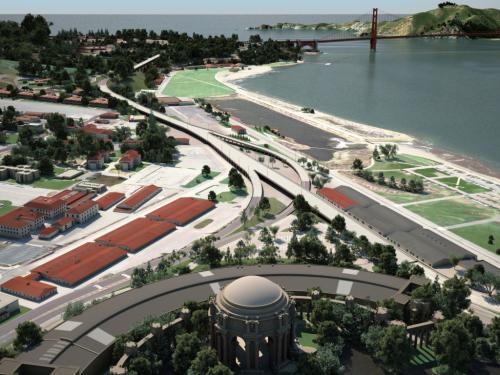
A rendering of the old Doyle Drive shows how the road bisected the Presidio. Image courtesy Presidio Parkway
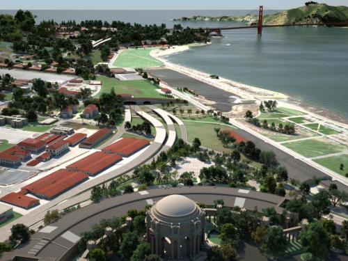
A rendering of the new Presido Parkway shows how the design will reconnect the Presido and Crissy Field. Image courtesy Presidio Parkway
Winners and Losers
I’d judge that SPUR got about 85 percent of what it wanted in, and out of, the project. We got the right design, and we got it into construction before an earthquake claimed the existing road. The national park will be quieter, more beautiful and much easier to get around. At six lanes, the overall road width will be 25 percent less wide than what traffic engineers originally demanded. We even got all but one lane in each direction narrowed to 11 feet. (The standard is 12 feet, which gives drivers more room to maneuver — and also encourages speeding.) Visitors, residents and Presidio workers will be able to enter the national park without driving through residential neighborhoods. The Painter concept saved taxpayers a couple of billion dollars.
At a few critical points, SPUR helped José-Luis Moscovich and his staff get millions in critical funding, but most credit for financing the project goes to the SFCTA’s effective work at all levels of government.
Lost in these plans, however, is the Palace of Fine Arts, at the Presidio Parkway’s eastern end. The great shed currently housing the Exploratorium will need a new tenant when the museum moves to its new home on the northern waterfront. But the city has ignored every opportunity to make the building attractive to others. The back of the building, facing the Presidio, features a seedy parking lot with one of the most spectacular views of the Golden Gate. For historic reasons, the lot is owned by the Presidio Trust, though managed by the city. Michael Painter produced numerous designs, and SPUR spent years trying to make this key site more attractive, but neither the city nor the federal agency could be bothered.
The biggest losers in this saga were some homeowners on Richardson Avenue and Lyon Street. SPUR offered them a design that would take Palace of Fine Arts traffic off of their street. Had they supported it, we might well have transformed the entire dowdy east entry to the Presidio, as well as the Palace grounds. But the homeowners were so focused on trying to shift Doyle Drive traffic from their street to Marina Boulevard (a fight they lost), that they passed on an opportunity that would have added hundreds of thousands of dollars to the value of their homes.
Lessons Learned
Question received wisdom. Traffic engineers shot down many of SPUR’s and Painter’s novel ideas as dangerous because they weren’t what drivers expected to experience. While it’s undeniable that drivers are creatures of habit, they can still adapt. Near the end of the negotiations, SPUR asked to see the literature on driver expectations. At a subsequent meeting, we asked again. A senior engineer quietly confessed, “There isn’t any.” So much for the scientific basis of policy.
Question traffic models. Computer modeling errs on the side of more, not less. Because the models encourage overbuilding, which attracts more traffic, they are often self-fulfilling. But because they carry the aura of certainty, you need professionals to challenge their results.
Public consultation easily goes off the rails. Fear of change can raise the most bizarre and unexpected concerns. The noisiest and most persistent community members often dominate the debates, escalating reasonable concerns into impossible-to-satisfy demands. Successfully taking a community’s real temperature is a skill, usually not taught, that planners must learn to master.

As traffic moves on Doyle Drive, the new road is built alongside. Photo by Michael Alexander
What’s in a name?
Doyle Drive has been jackhammered into history. Caltrans, sensing a minefield about naming rights, has provisionally called the new road the Presidio Parkway. Like the old road, it should be named for the man whose vision made it possible. I propose the Painter Presidio Parkway.
Watch a fly-over video of how the new parkway will transform the Presidio >>
Michael Alexander is an urbanist and co-chair of SPUR’s Advisory Council. He was a SPUR Board Member for two decades. He now lives in Vancouver B.C., where he helps implement innovative ideas from San Francisco.