
In a new exhibition, The City + The City, students of the California College of the Arts, working with the Urban Works Agency and the San Francisco Planning Department, explore how to add 100,000 housing units to San Francisco.
In a new exhibition, The City + The City, students of the California College of the Arts, working with the Urban Works Agency and the San Francisco Planning Department, explore how to add 100,000 housing units to San Francisco.
San Francisco’s chief economist has estimated that the city needs to build at least 100,000 units of housing to bring down its out-of-control rents. But where to put them? In The City + The City, a new exhibition at SPUR, architecture students share their innovative ideas about where those 100,000 units might fit.
San Francisco has become a victim of its own success. Its unique position as one of the most attractive and livable cities in North America and as the font of economic productivity from Silicon Valley has created a shockwave of wealth and population inflows. The resulting need for new housing has overwhelmed the city’s highly constrained urban form and pushed its social relations to the breaking point. The result is a San Francisco that threatens to divide into two cities: one built of luxury housing estates for the wealthy, and the other of minimal dwellings for the precarious workers of the post-crisis economy.
This crisis of housing affordability has become impossible to ignore. Short of a massive influx of public money, a dramatic increase in the supply of housing units has been seen as the only workable solution to meet demand and make housing more affordable. In early 2014, San Francisco’s Chief Economist estimated that it would be necessary to build 100,000 units of housing — equal to the amount of units constructed in the city since 1920 — to begin to have a stabilizing effect on median rents. But under the current physical and political constraints on the city’s built form, finding the space to create this amoun of new housing would make it necessary, in the words of San Francisco Supervisor David Campos, “to build another city on top of the city.”
The San Francisco Planning Department’s Affordable Housing Bonus Program (AHBP) proposes to do just that. In an effort to increase affordable housing and improve feasibility of projects on underutilized sites in the city’s mixed-use residential districts, the AHBP incentivizes developers by allowing a two story increase in building height above the current zoning envelope in exchange for an increase of the number of permanently affordable and middle-income housing units. This program opens up the potential for a more diffuse horizontal approach to density in neighborhoods in the outer districts of the city, presenting a form of density that is an alternative to the incremental “Manhattanization” of downtown and south of Market.
At the opposite end of the spectrum, alternative solutions are being explored by those without the means to participate in new development, including experiments with new forms of homesharing. Arising from the same technological impulses that fuel the economy of Silicon Valley, the so-called “sharing economy” has called into question the domestic unit itself, opening up renewed interest into contemporary forms of communes and co-living.
Using the goal of adding 100,000 housing units as an alibi, this design-research exhibition, the product of a series of seminars at the California College of the Arts and Yale University in 2015-16, explores the potential expressions of densifying neighborhoods from within through horizontally-distributed growth. Ranging from the redefinition of the “room” as the most basic element of domestic space to the form of the “unbuilt city” of underutilized zoning in the existing city, the exhibition puts forward the image of a new city of alternative housing typologies and larger collective forms that leverage San Francisco’s unique topographic conditions.
The students’ design research focused on land-locked neighborhood commercial districts as sites for new forms of horizontal density.
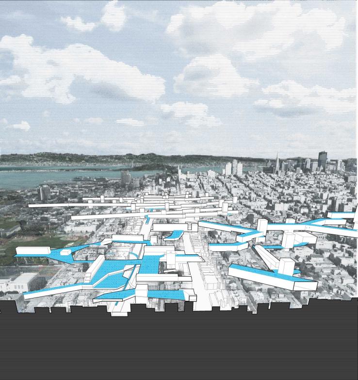
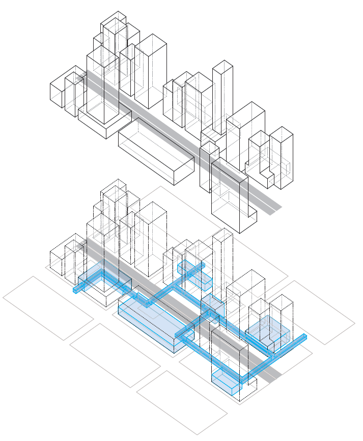
The students’ design research project focused on seven land-locked neighborhood commercial districts as sites for new forms of horizontal density. The site was the "unbuilt city" of underutilized zoning. At the outset, the space between existing building heights and the top of the zoning envelope was visualized, showing the volume of buildable space above each neighborhood as it exists, and as it could expand through the additional building height allowed under the new Affordable Housing Bonus Program.
To grasp the potential of the “unbuilt city,” the methods for visualizing it, and its relationship to the built city, were critical: The plan oblique offers a drawing technique that produces a three-dimensional representation while maintaining a “non-subjective” point of view, privileging objects’ geometrical and spatial relationships to each other and a larger organizing field, while confounding any subjective experiential reading of space. In addition, a “Choisy projection” of the plan oblique offers a worms-eye view drawing that allows the viewer to see the unbuilt volume in detail from below. Made famous by Auguste Choisy in the 19th century, this type of projection was used to analyze the tectonics of classical architecture, from the Greek temples to Gothic cathedrals.
Visualizing the impact of the design proposals required students to utilize a different drawing technique, employing what is sometimes called a “prospective view”: a bird’s eye perspective view of a city that is simultaneously a map and a picturesque vision. Historically, these drawings were used as promotional tools to attract residents, businesses, or investors to new cities or settlements, and thus had the double burden of having to both show the overall city form, as well as its salient features and individual structures. Often these cities were in actuality less developed than shown, thus the term “prospective” implies both a point of view and a form of conjecture. Placing the viewer both above the city, but still in it, the prospective views of the proposals for San Francisco project a new, near-future image of each neighborhood that illustrates both housing and new public spaces.
To develop design strategies for this “unbuilt city in the sky,” research drew on case studies outside of the specific context of San Francisco that provide examples of ways in which topography interacts with pedestrian and other traffic layers, and of innovative typological and programmatic relationships in conditions of high density. These precedents offer alternatives to the conventional urban condition of the singular public ground plane with private territories above. They include Hong Kong’s network of elevated pedestrian walkways, Edinburgh’s multi-level streets, Vienna’s rooftop additions, and urban projects like Weiss Manfredi’s Olympic Sculpture Park in Seattle, that negotiate steep topography to connect a public park, institutional buildings and car traffic together in innovative ways. The research explored these case studies for infrastructural operations that expand the public space of the city both horizontally and vertically and explore the trade-offs between public and private spaces that lay at the foundation of these alternative urban conditions. Strategies from these case studies informed proposals that inhabit, intensify, and at times, restructure the envelope of the ‘unbuilt city’ in ways that allow for larger collective forms to be developed in close dialog with San Francisco’s unique topography.
Hong Kong Central: The articulation between these crosses into a single elevated passageway generates a second layer of public transportation. The elevated crossing connects several buildings as well as connecting private commercial spaces to public pathways. This is a way of relieving the lack of open spaces in a highly dense urban environment.
In her 1999 book, The Grid meets the Hills, architect Florence Lipsky drew attention to the tensions between the logic of San Francisco’s urban grid and its terrain. The relationships between the volume of the "unbuilt city" and the topographic change in each neighborhood highlight the potential for altered topographic conditions, additional pedestrian and bicycle networks, and new public realms. At the urban scale, the expansion of the zoning envelope raises questions about allowable vs. desirable building heights, and the programmatic implications of creating new levels of public access. The development of strategies for the “unbuilt city” was used here to engage in a broader conversation about the dialog of topography, transportation infrastructure, and the emerging programmatic and typological opportunities. Specifically, the design research focused on ways to leverage the Affordable Housing Bonus Program as a path to creating collective urban-scale projects that explore the tension between grid and topography as place of opportunity for public benefit. The resulting neighborhood-scale proposals produce architecture/infrastructure hybrids that embrace the existing city, engage with the ground more intimately, and produce rich new intersections of public and private space.