

This article is excerpted from the SPUR report On Solid Ground. Read the complete report at spur.org/onsolidground >>
The United States Geological Survey estimates that there is a 63 percent chance of a large earthquake occurring in the Bay Area sometime in the next 30 years. At the same time, we will be adding more than 2 million new residents to our region in the next 30 years, bringing the Bay Area’s total population to more than 9 million. Some of the areas targeted for the highest levels of future development are susceptible to earthquake-related hazards, including liquefaction (when strong shaking causes soils to behave like liquid) and tsunami inundation, as well as other hazards such as sea level rise.
Many of these places currently support regionally important economic hubs and are home to dense communities. The Bay Area’s infrastructure and population centers were developed long before these were recognized as high-hazard areas. While the region is making strides to protect these investments, we have more work to do. We need to consider earthquake risks when developing new land use plans. We need to build a culture of preparedness around our planning activities, continuously updating our plans and codes so that when the next earthquake strikes, we will be in a position to rebuild quickly and well. If we fail to do so, we run the risk of undermining the economy of the entire region and losing our residents, perhaps permanently.
Though many jurisdictions in the Bay Area have well-defined plans to address disaster response in the immediate days and weeks following an earthquake, most have not developed comprehensive recovery and rebuilding plans for the months and years after a major seismic event. This should not come as a surprise: It is very difficult to determine before a major earthquake exactly which areas will be damaged. In addition, recovery planning requires cooperation across departments that may not have a history of working together. Further, recovery planning is not typically a well-funded activity for local governments.
SPUR's new report On Solid Ground deals with one crucial set of disaster recovery activities: those that focus on land use planning and rebuilding. Land use planning refers to the set of decisions that determine what gets built where — and how. This includes the adoption of land use plans that set the vision for growth in a community (such as a city’s general plan or a specific plan for a neighborhood), as well as zoning decisions that govern the height, bulk and allowable uses of buildings. It also includes decisions about which seismic codes new buildings will be required to meet following the disaster.
Land use planning also includes decisions about where not to build. We may, for example, decide that certain areas should be left as open space because they are poorly served by existing infrastructure or because they are subject to so many hazards (including liquefaction, flooding and sea level rise) that they are unsafe to inhabit.
Local governments are responsible for almost all land use decisions within their boundaries. Zoning, general plan amendments and building permitting are done by local government. After a disaster, local governments will be responsible for developing a vision for their communities’ recoveries, determining what will be rebuilt the same as it was before the disaster and what will be rebuilt differently. They will need to develop new planning processes, both to help speed permitting in areas that are being rebuilt according to existing zoning and to create processes that involve the public in deciding how to rebuild areas with severe damage. Local governments will need to find ways to work with regional agencies, utility providers and others to make sure that the infrastructure needed to support recovery is rebuilt quickly and effectively. And they will need to find ways to communicate effectively with residents throughout the recovery process.
Jurisdictions seeking to rebuild in the months and years following a disaster will face difficult questions. How should local governments balance the need to rebuild quickly with the need to create a public process to guide decision-making? What regulatory tools can local governments make use of to aid recovery? How should we think about planning for growth in areas of liquefaction? What state and federal financing will be available to local governments after an earthquake, and how should local governments plan to channel this funding to facilitate their recovery? What types of information does the public sector need to collect now in order to rebuild after a disaster, and what types of information will businesses and residents need to help make their own rebuilding decisions?
There are no easy answers to these questions. However, having a clear understanding of some of the challenges local governments will face in the recovery period can lead these agencies to take action now — before the next major disaster strikes If we begin planning now, we will be much more likely to recover quickly after a major earthquake. Local jurisdictions that lay the groundwork for rebuilding — by continuously updating their general plans and zoning codes before the disaster — will be in a much better place to begin a conversation with residents about a recovery vision. By understanding local earthquake hazards and addressing them before the disaster, jurisdictions can reduce the amount of damage their cities will face and the amount of rebuilding in the recovery period. And by making needed regulatory changes before the disaster, local governments will have the tools they need to facilitate recovery.
If we fail to begin planning before the disaster, we run the risk of undermining our future recovery. Buildings and infrastructure that haven’t been planned with earthquake risk in mind could be severely damaged after a major event. Jurisdictions that haven’t continuously updated their general plans and zoning codes in the pre-disaster period may be forced to do so after disaster strikes — when time is short and emotions run high. Without the necessary procedures in place to receive public funding for recovery, local governments could lose out on the resources they will need to rebuild their cities. The good news is that there are many steps we can take in advance of the next earthquake to ensure a successful recovery.
After first responders (police, firefighters and the like) cope with the immediate challenges of disaster response, questions related to long-term recovery will quickly emerge. How will damaged areas be rebuilt? When will utility services be back on line? Which areas are safe to return to and which are not? What financing is available to assist in rebuilding?
Local governments will need to find ways to answer these questions in the months following a disaster. Without a clear process in place for deliberative decision-making, the tendency will be to act now and think later. Some have described this phenomenon as “ready, fire, aim.” While this approach can satisfy the desire to act quickly to facilitate recovery, it can lead to missteps and missed opportunities. It can also cause upset and confusion later if earlier decisions need to be rethought in order to support a better outcome.
SPUR recommends instead a process of “gearing up and sorting out.” This involves working through the series of steps and questions outlined below. The answers to the questions will differ from jurisdiction to jurisdiction based on the nature of the damage, the type of recovery that is needed and the jurisdiction’s capacity to undertake recovery activities.
Confusion, uncertainty and incomplete and/or inaccurate information are endemic to an emergency and recovery. It’s easy to get lost in the details, and it’s difficult to step back and reflect on the bigger picture. Recovery starts with damage assessment, and then follows with an analysis of how that damage defines what must be done to emerge whole again.
Each community’s recovery has to be self-defined, for the community as a whole and for its individual neighborhoods. Any community affected by an earthquake will likely grapple with many simultaneous recoveries: of neighborhoods and business districts, port facilities, infrastructure and more. This will call for coordinated thinking at both the neighborhood and citywide level. Ideally, each community will develop and articulate a vision that captures what it is seeking to become and how the pieces will fit together. The viability of a plan depends on making sure its ideas are in sync with larger forces, such as market forces and demographic trends, and that it’s technically feasible. Outside expertise can be invaluable in helping to define the recovery vision.
Making priorities is difficult, but in the recovery period it is simply impossible to put the appropriate time, money and energy into everything that’s needed. Triage is a useful concept. The community will need to focus on identifying and then doing those things that are both critical and feasible.
After a disaster, many community members may have an initial impulse to put things back the way they were, but recovery efforts must shift from looking back at the past to imagining a different but achievable future. This is an opportunity to consider changes that could be transformative and to determine whether they are viable.
Each intervention will need to have a well-conceived and appropriate planning approach.
In this step, outcomes begin to meet strategies and processes. A community must determine the appropriate path and process for each of the many recovery tasks; this will require defining the leaders and stakeholders and specifying the community involvement. This is also an area that may require outside expertise and experience.
The local government usually takes the lead in implementing the recovery vision, which will likely require organizational adaptations and additional resources. Political and administrative leaders may need to redefine their level of oversight and control; organizations in turn may require reinvention or reorganization.
Recovery planning entails defining detailed timelines and benchmarks that will move a general recovery vision toward the specific decisions, policies and implementing mechanisms. The process must be fully understood by all parties involved in implementing it. False starts and backtracking, which can result from overly bureaucratic processes or poor political leadership, can severely undermine recovery efforts and should be avoided.
The need for information (e.g., information about what has been damaged, how much it will cost to rebuild, when utility service will be restored, etc.) is a constant throughout the recovery process. Because there will never be enough information at any given moment, each step will involve discomfort and uncertainty. Mistakes are inevitable but can be minimized if we make sure that we know enough to have a reasonable basis for any particular course of action.
Post-disaster, decisions will be organic and circumstantial, and it is not unusual for people to emerge with roles or responsibilities they never anticipated. Recovery processes must adapt and respond in new and unexpected ways under pressure. No matter how well a community has planned for recovery, the process will demand improvisation. This can be especially difficult for those government organizations that tend to be risk-averse and to reward caution and routine. Those departments and individuals that are adept at self-assessment (meaning they understand their strengths and the limits of their capabilities and can therefore better seek guidance and expertise) are more likely to succeed.
In the process of gearing up and sorting out, local governments will need to decide what to rebuild and repair according to current plans and codes versus what to re-plan after a disaster.
Rebuilding and repairing according to current plans means building structures to conform with zoning, general plans, specific area plans and other adopted area plans that were in place before the disaster. It also means repairing structures to conform with California Building Code requirements and any existing local interpretations of the code. For areas that are being rebuilt according to existing plans and codes, local jurisdictions need to develop permitting processes to enable private individuals to rapidly rebuild their properties.
Re-planning occurs when a jurisdiction adopts new zoning regulations and new general plan updates and specific area plans after a disaster. It can also include building code upgrades that require greater strengthening or other measures to increase seismic performance. For areas that need to be replanned, local jurisdictions need to develop planning processes that are inclusive and clear and transparent and efforts must be made to ensure that those who have been displaced by the disaster are able to participate in the re-planning process.
Of course there are gray areas between these two categories of action. Interpreting the requirements of the current building code to assure that postearthquake repair and retrofit standards can be met could fit in either category. And actions from both categories will occur in different parts of a local jurisdiction at various times during the recovery period. In addition, local governments will likely take steps to allow for interim or temporary rebuilding activities to help facilitate recovery. These interim steps could potentially precede a re-planning process.
The decision to rebuild and repair to current plans and codes or to rebuild according to new plans and codes will be informed by a variety of factors, including:
If an area is severely damaged and/or if the damage covers a wide area, a jurisdiction may engage in a re-planning process. If the damage is more minimal, a re-planning process may not be necessary.
If a heavily damaged area is located in a liquefaction zone or another hazardous area, local jurisdictions may develop mitigation measures to alleviate the hazardous conditions and/or create new standards for development. Local jurisdictions may want to consider rezoning areas that pose serious risks for major damage in the future. This issue is explored in more detail later in this article. (See “Earthquake Hazards in the Bay Area” below.)
Many jurisdictions engage in planning activities on an ongoing basis, developing new area plans and updating zoning. The creation of a new area plan is often the result of a community planning effort involving a variety of stakeholders. If a disaster strikes an area that has recently undergone a major planning effort, it is helpful to have a vision for recovery that residents have recently agreed upon, such as a newly adopted area plan. Some jurisdictions, on the other hand, have outdated general plans and zoning for portions of their cities. Sometimes zoning may not be consistent with the general plan. Local planning departments should keep their general plans and zoning current so that decisions to change plans and zoning in the postdisaster period can be kept to a minimum.
The Importance of Advance Planning: Lessons Learned from Recent Disasters

In many recent disasters around the world, governments took steps before the disaster to aid recovery. Those jurisdictions that did not do advance planning work had a much harder time rebuilding quickly after a disaster.
It is politically difficult for jurisdictions to tell private property owners that they cannot rebuild their homes and businesses as they were before the disaster. It may be easier to make changes to publicly owned land and infrastructure. For example, San Francisco replaced the Embarcadero Freeway with a surface boulevard after the Loma Prieta Earthquake. This radical change in public infrastructure opened up the city to the bay and allowed for the development of a new neighborhood (South Beach) and the AT&T Ballpark.
If an area heavily impacted by a disaster is unlikely to receive the private investment necessary to recover, a re-planning process — coupled with tools to help stoke investment interest — may be necessary to jumpstart recovery. Local jurisdictions may also engage in re-planning to capitalize on economic development opportunities in the wake of a disaster.
Land and property ownership structures can complicate recovery. An individual owner of a single-family home who has access to the resources necessary for repair may be more likely to rebuild after a disaster than the owner of a condominium in a multiunit building who has to engage in decision-making with many people through a condo association. Renters will be unable to make decisions about whether or not their units are rebuilt. Owners’ decisions regarding rental properties will have a substantial impact on recovery, especially in cities with high renter populations, such as San Francisco.
After a disaster, some jurisdictions, especially small ones with very few planning staffers, may lack the capacity to engage in a re-planning process, in which case they would require outside resources in order to engage in a re-planning process.
Government action is not the only driver of recovery efforts. Private individuals, financial institutions and investors will also be making decisions about recovery in response to a separate but related series of factors. If private individuals do not seek to stay in their community and participate in rebuilding, recovery may not occur.
Liquefaction — Strong earthquake shaking can cause soil to lose strength and behave as a liquid, displacing the ground that supports building foundations. Structures can settle, tip or be otherwise damaged. Areas most susceptible to liquefaction have loose, granular soils that are saturated by groundwater. Older artificially filled areas, like many of the areas around the margin of the bay, are particularly susceptible to liquefaction because they were created when the Bay Area was first developed, when no one understood the dangers. Damage resulting from liquefaction does not typically make buildings collapse, but it can cause significant damage to buildings and buried lifelines, such as water and power lines. Structures affected by liquefaction often need to be reconstructed.
Tsunami — A tsunami is a series of waves generated in a body of water by a rapid disturbance — such as an earthquake on an underwater fault— that vertically displaces the water. Tsunamis affecting the Bay Area are rare but could be caused by nearby offshore earthquakes or by very distant events.
Landslides — Landslides can be triggered by earthquake shaking and can damage or destroy entire hillside developments. These landslides may displace the ground surface only a few centimeters, or they may cause slope failures, where entire hillsides slide in rapidly moving masses. A variety of landslide hazard maps have been produced for parts of the Bay Area, and these maps can be used to plan for slope failure.
Surface Fault Rupture — Faults are fractures along which blocks of the earth’s crust slide past each other. Earthquakes occur when forces underground cause the faults beneath us to rupture and suddenly slip. If the rupture extends to the surface, then part of the ground shifts, ripping apart any structures directly on the rupture line. Fault rupture damage is rare and confined to a small zone, but it is visually striking. According to state law, construction near mapped fault lines must verify the fault location through digging trenches and conducting other geologic studies.

In every future earthquake, some locations in the Bay Area can be expected to experience heavier damage than neighboring areas unless we take steps to develop these areas in ways that minimize the risk. Earthquake hazards — including liquefaction, lateral spreading, landslides, surface fault rupture and tsunami — are all phenomena caused by strong ground shaking, but they are separate and distinct processes that occur in predictable locations. Because we know where earthquake hazards are likely to occur, it makes sense to address these risks through our codes and land use plans.
Different earthquake hazards affect low-lying areas and hillside areas. Low-lying areas near the San Francisco Bay and in inland valleys face the threat of liquefaction and tsunamis. Many of these low-lying areas are also subject to flooding and sea level rise. Although these last two risks are not triggered by earthquakes they provide extra incentive to manage development in these areas with building codes, zoning codes and land use plans that recognize the hazards. Hillside areas face their own set of earthquake hazards, including earthquake-induced landslides and surface fault rupture. Most notably, the Hayward Fault crosses through heavily developed areas in East Bay cities at the base of the foothills. Hillside areas are also prone to hazards not triggered by earthquakes, including wildfire and rainfallinduced landslides.
The bulk of the region’s earthquake-related risk lies in the low-lying plains near the bay, where liquefaction will occur. These areas ringing the bay are home to our major urban centers: San Francisco, Oakland and San Jose. Densely occupied, these zones contain most of the region’s job centers and the bulk of its multifamily housing. The proliferation of hightech companies in Silicon Valley has furthered this trend. Downtown San Francisco, with the greatest concentration of tall buildings in the region, sits on poor soils. Between 1850 and 1960, filling the bay was one way to provide more land for ports, industrial uses, airport runways and housing. The region’s garbage was conveniently used to fill this land, and nobody realized then that this technique created land with very high liquefaction risk.
We can expect to see devastating and widespread damage from liquefaction in future Bay Area earthquakes. The scale and location of the damage will depend upon the size and epicenter of the earthquake, but we should expect areas close to the bay to be hit hard.
Critical infrastructure crosses our hazard zones. Major transportation corridors (Highways 101, 80, 580, 880 and 680) run north and south and parallel to the region’s valleys and low-lying areas. These corridors are connected by roads, tunnels and bridges running east and west, some of which cross faults. Major transmission infrastructure bringing water and power to our region also crosses this system of faults as it travels westward. Many of our ports, airports and sewer-treatment facilities are located adjacent to the bay on weak soils.
Liquefaction Susceptibility in the Bay Area
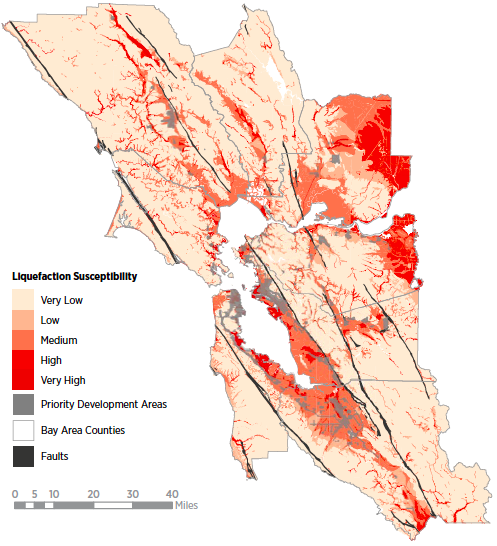
Many parts of the Bay Area facing risk from earthquake hazards (including liquefaction susceptibility, as shown here) will continue to be developed in the coming years as the region figures out how to accommodate more than 2 million expected new residents in the coming 30 years. The region has committed itself to reducing sprawl by accommodating new housing and jobs near transit within existing urban areas, which SPUR strongly supports. However, some of the areas best served by transit are also subject to liquefaction, tsunamis, sea level rise and flooding, putting more people at risk from a variety of hazards. Good planning is needed to address these risks.
There are three key approaches to reduce the potential damage from earthquake hazards:
1. Make improvements or changes to the land to reduce the hazards.
2. Build in special ways in the hazard zones to reduce damage when earthquakes occur.
3. Develop land use plans that avoid concentrating dense uses in earthquake hazard areas.
In many locations, it is not feasible to alter the land enough to eliminate the risk of liquefaction. Instead, new buildings can use specially designed foundations, which would reduce the risk and typically add less than 10 percent of the total building cost to a project.
The real challenge is to address the liquefaction risk for existing buildings with inadequate foundations. Retrofits to foundations are difficult, expensive and often not feasible. Typical above-ground retrofit techniques help increase the resilience of structures in liquefaction zones, but they may not be adequate to avoid heavy damage.
The most effective way to reduce damage from secondary hazards is not to build where they occur. This is currently not an option in many parts of the Bay Area, although it may become feasible if large areas experience heavy damage in a future earthquake. As an example of this approach, the plan to redevelop Treasure Island leaves the northeast corner of the island as parkland in part becauseliquefaction risk is highest on that part of the island.
The period after an earthquake is an opportunity to repair and rebuild better and to reduce the likelihood of damage in future earthquakes. It is cost-effective to make seismic improvements to structures when they are already undergoing repairs or reconstruction. This is also the time when a community might best find the political will to make significant land use or building regulation changes in a high-risk neighborhood.
A plethora of complex regulations govern postearthquake building repair and reconstruction. The application of regular codes — typically the California Building Code with some local amendments — will generally form the technical basis for repair and reconstruction, but a host of special regulations offer challenges and opportunities. It will be difficult for an individual building owner or design professional to become familiar with so many regulations, and a lack of clarity may result in extensive delays or in repairs or reconstruction that do not fulfill an owner’s or jurisdiction’s goals or requirements. Cities and regions can accelerate post-disaster recovery by adopting clear policies and procedures on post-earthquake building evaluation, repair and reconstruction.

After a disaster, local governments will work to develop a vision for recovery that includes making decisions about which areas to rebuild according to existing plans and codes, which ones to re-plan and how to do it. To carry out this recovery vision, private property owners will need to know the rules that govern rebuilding, such as whether or not rebuilding their property requires environmental review, whether or not they will be allowed to rebuild structures that do not meet current codes and whether or not they can substantially alter historic buildings. Local governments will have to answer the same questions when considering the rebuilding of public property and infrastructure. To do so, they must be aware of existing state and federal regulations that impact these types of decisions and must consider how these regulations might change in the post-disaster period.
Certain types of regulations, such as those laid out in the California Environmental Quality Act (CEQA) and National Environmental Policy Act (NEPA), contain specific exemptions that apply in a post-disaster period. Others, like those protections specified in historic preservation law, offer guidance for how to deal with historic resources after an earthquake. Still other parts of state law, such as the section that allows for the creation of reconstruction authorities in the wake of a major earthquake, provide tools that can be used only following a disaster.
At the same time, complex planning challenges will have to be addressed. What tools will we need in the post-disaster period to aid the recovery of areas that have been severely damaged? What role might reconstruction authorities play now that California has eliminated its state redevelopment agencies? How do we preserve affordable housing to prevent permanent economic displacement after a disaster?
Most planning actions in the Bay Area require environmental review. There are two umbrella regulations that could affect Bay Area jurisdictions: the National Environmental Policy Act (NEPA) and the California Environmental Quality Act (CEQA). We use the term “umbrella” because NEPA and CEQA review often encompasses review of other environmental regulations that may apply to the project. These include requirements under the Clean Water Act, the Clean Air Act, the Endangered Species Act and the National Historic Preservation Act.
Both NEPA and CEQA pose challenges in the recovery period. The environmental review procedures of these acts can often take a long time and thus may not work well in post-disaster recovery, when improvements need to happen quickly. For large projects — including new neighborhood plans and infrastructure replacement plans that do not simply replicate what existed before the disaster — the preparation of full environmental impact statements (EISs) under NEPA or environmental impact reports (EIRs) under CEQA could be required. Preparing and adopting an EIR or EIS can take years, even under non-disaster conditions. Such a lengthy process could pose substantial problems after a major disaster. However, both NEPA and CEQA contain exemptions that local jurisdictions may be able to use to support disaster mitigation, response and recovery activities in the wake of a natural disaster such as a major earthquake.
In previous disasters in California, redevelopment agencies played a role in facilitating recovery. Now that California redevelopment agencies have been dissolved, the state has lost the capacity to create new redevelopment areas and to expedite the adoption of redevelopment plans in the wake of a disaster.
California’s community redevelopment law previously enabled local governments to create postdisaster redevelopment agencies with the power to use tax increment financing to rebuild infrastructure and spur private development and with the power to assemble parcels, sometimes by invoking eminent domain. The Community Redevelopment Disaster Project Lawallowed local governments to quickly establish a redevelopment agency and adopt a redevelopment plan if the governor declared that the plan area was in need of assistance and the plan area was within a presidentially declared major disaster area.
Fortunately, a separate provision of state law allows for the creation of reconstruction authorities “with powers parallel to those of a community redevelopment agency, except that the reconstruction authority would be authorized to operate beyond the confines of designated redevelopment areas and would have financing sources other than tax increment sources.” This section is known as the Disaster Recovery and Reconstruction Act of 1986.
But it is unclear what powers these reconstruction authorities would have, if any, since community redevelopment agencies no longer exist. This law needs to be amended to be more explicit about the powers available to reconstruction authorities now that redevelopment agencies have been dissolved.
Often, a previously allowable use of property continues to exist in an area where the zoning has changed. For example, sometimes light industry operates in a neighborhood now zoned only for residential use. This is known as a “nonconforming use.” In other cases zoning changes and code upgrades can create certain rules for new development (such as requirements to provide or limit a certain amount of parking per unit, setback requirements, bedroom size requirements, etc.) that existing development does not meet. The pre-existing buildings are called “non-complying structures.”
After a disaster, if the existing codes do not already specify, planners and building officials will need to decide whether to allow owners to rebuild non-conforming uses and non-complying structures or whether to require owners to meet current zoning and building codes. Most likely, they will have to make these decisions in the face of enormous pressure to let owners rebuild what existed before the disaster and to waive planning and building requirements to the extent allowed by state law.
Dealing with non-conforming uses and noncomplying structures is going to be one of the key challenges in the post-disaster period. Requiring owners to build to current standards will likely increase the seismic resilience of the entire city. However, funding for the repair and replacement of private structures may not be sufficient to cover the entire cost of upgrading a structure to current standards. This may lead private owners to choose not to reinvest in their properties.
After a disaster, many historic buildings may be damaged, as may buildings that are not listed as historic resources but that add to community character. In the post-disaster period, it will be difficult to sort out which buildings are critical to preserve even if they have sustained substantial damage. Policy-makers will need to weigh the importance of the resource against the degree of the damage and consider the impact of aftershocks, which may harm the resource even more and pose additional safety concerns.
If policy-makers are too quick to issue demolition permits, valuable historic resources could be lost. The good bones and fine character that many historic buildings provide can serve as anchors for re-planning neighborhoods that experience major damage after an earthquake. In instances where too many historic resources are destroyed in favor of new development, the character of neighborhoods can erode. At the same time, delaying demolition can lead to potential safety hazards, especially if aftershocks occur. Denying demolition permits without providing resources for historic rehabilitation can delay recovery if buildings are boarded up for long periods of time.
Housing is integral to every aspect of a city’s recovery: Businesses, neighborhood districts, schools and cultural institutions all rely on residents being able to stay in their jurisdiction after a disaster. If people can remain in their homes, they will be better able to put their energy and resources into rebuilding their neighborhoods. If they leave the city, they may not return, and recovery may be substantially delayed.
Low-income households are disproportionately impacted by disaster. While wealthier households can relocate for awhile and make use of their private resources to rebuild their homes, low-income families may need to rely more heavily on public resources during the period immediately following a disaster, and they may require additional help with long-term recovery.
Exacerbating the discrepancy, in some areas lowincome households are more likely to live in housing that’s vulnerable to earthquake damage, including units that are rent-controlled or “naturally affordable” because they have not been well maintained, they’re located in low-income neighborhoods or they’re small (e.g., single-room occupancy units). In San Francisco, some of the rent-controlled housing lies in liquefaction areas. Many rent-controlled buildings have not been properly retrofitted, partly because rent control law prevents landlords from passing on the cost of certain types of retrofits to tenants. In other parts of the region, such as the “flats” of the East Bay, low-income households live in areas susceptible to liquefaction and in housing that may not withstand an earthquake. If large swaths of lowlying liquefaction-prone areas experience significant damage after a major earthquake, it may be difficult to encourage private owners, particularly owners of multifamily housing, to rebuild. Even if housing is rebuilt, there is no guarantee that the people who lived there before will return.
Permanently affordable subsidized housing is much more likely to fare well after a disaster. Typically, this type of affordable housing is owned by a socially motivated nonprofit that is trying to both preserve the building and serve low-income households over time. Providers of affordable housing often invest in strengthening their buildings through rehabilitation projects. After a disaster, they will continue to serve low-income populations. However, many affordable housing providers don’t have sufficient earthquake insurance due to the expense and the fact that this type of insurance does not provide substantial coverage. After a disaster, affordable housing providers may need additional assistance to repair and rebuild.
Much of the region’s public housing (housing owned and managed by the federal government through local housing authorities) was built quickly and inexpensively in the 1950s and ’60s. Governmental authorities have repeatedly cut funding over the past several decades, which has significantly delayed the upkeep and maintenance of these buildings. It is unclear how this housing will perform in a major earthquake.
Money is the fuel for disaster recovery: It largely determines what gets rebuilt and when. Even if communities engage in rigorous efforts to develop comprehensive recovery and rebuilding plans before a disaster strikes, implementing the plans is always contingent on funding.
Financing disaster recovery is particularly challenging when a community aspires to rebuild in ways that do not conform to pre-disaster conditions. Insurance policies and federal disaster recovery assistance programs, such as FEMA’s Public Assistance Program insurance, are not always flexible enough to allow for alternatives or improvements that meet a community’s desires. If a community decides to use the post-disaster window of opportunity to implement improvements or rebuild in a more resilient way, it will need to engage a wide range of public and private stakeholders and resources — and then package and apply those resources in new and creative ways.
In the wake of a major earthquake in the Bay Area, disaster-impacted cities will face major long-term challenges in obtaining recovery funding. Studies show that the cost to rebuild damaged housing, businesses and infrastructure following a magnitude 7 earthquake on the Hayward Fault (similar to the one that occurred in 1868) would likely exceed $100 billion; following an event similar to the magnitude 7.9 earthquake that occurred on the San Andreas Fault in 1906, this cost would likely exceed $150 billion.
In the most severely affected communities, local governments will be overwhelmed by the disaster. The extraordinary demands of responding to the earthquake will exceed available resources, requiring significant state and federal assistance. The local government’s workforce will be disrupted by facility damage, the displacement of workers and a lack of funding to sustain government operations. The earthquake will also impact the local economy, reducing tax receipts and the availability of resources for long-term recovery. Additionally, public coffers may already be limited given the economic downturn of recent years and the loss of some key financing mechanisms, such as redevelopment funds. These factors may prevent our region’s local governments from leading a sustainable community recovery and from implementing any improvements to rebuilding.
Recovery-related funding from the state and federal governments is primarily intended to supplement community resources to repair damaged public infrastructure and facilities. State and federal funds that go directly to the private sector have traditionally provided assistance in the form of loans for small businesses and funds for temporary housing and replacing damaged contents and goods. The massive impact of a major Bay Area earthquake will require a significant level of state and federal government assistance. This also means that these levels of government will play a central role in the Bay Area’s recovery. The sheer volume of local governments, public districts, nonprofits and other qualifying agencies applying for these funds will cause delays in the timing and delivery of assistance.
As we’ve seen with Hurrican Sandy, existing state and federal government assistance programs do not always provide resources that are required or desired. Often the funding doesn’t come quickly enough and requires extensive application processes. Simply put, most of this money doesn’t just flow; it has to be granted, which means that jurisdictions have to file project worksheets for Public Assistance, applications for FEMA Hazard Mitigation Grant Program funds and action plans for U.S. Department of Housing and Urban Development funding. Some programs require significant state and local matching funds and have other conditions and requirements that must be met. As a result, there will be bottlenecks at the state and federal levels in both processing and managing these program streams.
Working with state and federal government assistance programs may be particularly challenging when community recovery means more than simply restoring buildings and infrastructure to pre-disaster conditions. Communities may raise many questions about designing and implementing recovery strategies. Is it really cost-effective to repair public infrastructure just as it was? Should certain pieces of infrastructure be rebuilt differently? Are there opportunities to improve or replace existing buildings or systems that are aging or obsolete? Are there private-sector buildings and infrastructure for which the public sector should provide funding? Many assistance programs are not sufficiently flexible to accommodate these considerations. It is possible that the earthquake would have such a severe and widespread impact that it would trigger state and federal legislation approving supplemental funding to meet the longer-term challenges of rebuilding housing, infrastructure and local economies. But getting this legislation passed — and ensuring that it provides enough funding — is not guaranteed.
Some communities create new revenue streams to make up for their post-disaster funding shortfalls and facilitate recovery. For example, following the 1989 Loma Prieta Earthquake, the voters of Santa Cruz County and the county’s cities approved a 0.5 to 1 percent transaction and use tax to help finance capital improvements and public projects related to earthquake recovery. However, a community’s ability to pass such measures depends heavily on the timing of election cycles and the willingness of two-thirds of the electorate to approve the new taxes.
Ultimately, the Bay Area’s communities will need to work collaboratively and creatively with each other, state and federal partners, local residents and businesses, and other investors and philanthropic organizations to craft a sustainable recovery vision and assemble the necessary funding to achieve it.
Following a disaster, communities will need meaningful, up-to-date information to complete comprehensive damage and loss assessments for public facilities and infrastructure, private housing and commercial buildings. Information about occupancy, business continuity, employment and the availability of utilities and transportation will help inform both short-term and long-term recovery policies. Yet in the post-disaster period, good data may not be readily available. Without it, communities will plan to rebuild based on intuition and improvisation, potentially making decisions that will not allow for a speedy and effective recovery.
Many local jurisdictions may not have good planning and land use data (such as zoning, property titles, location of utilities and building types) that is available to the public in a readily usable format. This lack of easily sharable and usable data is problematic for two reasons. First, such data is going to be critical in the post-disaster period in order to conduct even rudimentary planning efforts. Some areas are likely to be so damaged that existing markers such as street signs, property line markers and even buildings themselves will no longer exist. Having an available bank of data will help planners determine what property has been lost, where streets used to be and who used to live where. Without such information, it will be nearly impossible to begin planning for recovery.
The second problem posed by this lack of data is that decision-makers could be using it in the pre-disaster period to craft mitigation policies that would help position cities to recover more efficiently after a disaster. Clear information about liquefaction and landslide risks and the seismic performance of existing building types can shape mitigation policies. For example, San Francisco and Berkeley have compiled GIS information identifying the characteristics and locations of their most vulnerable buildings, such as unreinforced masonry buildings, soft-story buildings, tilt-up concrete structures and weak concrete structures. Such data can empower planners to develop targeted programs to strengthen buildings prior to a disaster.
After a disaster, collecting data quickly and accurately is vital to the recovery planning process. Planners and decision-makers need to know what level of damage has been sustained by infrastructure and public and private buildings in order to predict the social and economic consequences. Post-disaster data informs the recovery planning process by helping to define the level of damage to residences, privately owned buildings and publicly owned infrastructure. It is also needed to help consider future land uses.
The Bay Area a region at substantial risk for a major earthquake. Large portions of its population live in close proximity to the San Andreas and Hayward faults. And those faults have a 63 percent chance of rupturing sometime in the next 30 years. If we do nothing to plan for our recovery, we run the risk of losing our major businesses and our economic base. Those with the opportunity to invest in other parts of the country or the world could choose to do so. Residents with resources could decide to move away. At the same time, vulnerable populations, such as low-income households and seniors, could be permanently displaced. Simply put, the Bay Area could cease to be the great region that it is today.
Fortunately, there are steps we can take to plan for recovery. We can update our general plans and codes now so that we have an agreed-upon vision of how to rebuild after the disaster. We can change our land use regulations to better facilitate recovery. We can consider geological risks, such as liquefaction, when crafting future land use plans. And we can collect the information we will need to facilitate rebuilding.
Taking these steps requires an investment of time, energy and political capital. Given the financial circumstances many local jurisdictions are facing, it may be difficult to devote resources to planning activities that will support long-term recovery. But the cost of doing nothing is enormous. If we begin planning now, we have the opportunity to create the solid groundwork that we’ll need to support a successful recovery.
This article is excerpted from the SPUR report On Solid Ground. Read the complete report at spur.org/onsolidground >>