

Photo by David Iliff
Photo by David Iliff
London is vulnerable to flooding due to both tidal surges and heavy rainfall. To prevent such events, the Thames Barrier was built in 1982 and has been closed more than 170 times since. While events as deadly as the 1953 North Sea flood — which killed 307 people — are now avoidable, rising sea levels and increasingly extreme weather conditions have led to much more frequent use of the Barrier in the last decades.
The Thames Barrier stretches across a third of a mile and is composed of nine iconic piers, which provide six navigable spans. The gates are shaped as circular sections that rotate to a 90-degree angle with the riverbed when the Barrier is closed. Construction took about ten years and cost the British government £1.6 billion ($2.7 billion) in today’s prices. This major infrastructure investment quickly paid off by preventing damage to Britain’s economic core on numerous occasions.
The barrier has been closed by the British Environment Agency (BEA) with increased frequency of late, and nearly a third of total closures since 1982 occurred just last year. The combined effect of sea level rise and adverse weather conditions has increased flooding risk, revealing London’s dependence on efficient adaptation measures. Not much a part of the discourse then, climate change had not been taken into account when the Thames Barrier was designed over 30 years ago. Now, with current knowledge on sea level rise, the BEA considers the barrier to be viable only until 2070. Considering that such a large infrastructure project requires decades of planning and design, academics and experts have begun to explore options to retrofit, expand, or even replace the barrier.
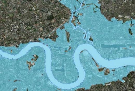 Without the Thames Barrier, London could be affected by flooding form the sea.
SPUR has long paid close attention to the effects of sea level rise on the Bay Area and to adaptation strategies for responding to it. While the geographies clearly differ, we can learn a great deal from London’s Thames Barrier. In London, as in San Francisco, damage due to inundations is greatest when a storm surge is combined with high tides. A barrier located at the Golden Gate could help prevent floods due to these conditions, operating in a similar fashion to the Thames Barrier. While it would not address the structural consequences of sea level rise, such a project could prevent disastrous inundations due to occasional weather and tidal events.
However, the biggest lessons to be learned lie not in the Thames Barrier itself, but in the policy framework that surrounds it. Although such a large and visible infrastructure project has undeniable political appeal, it is effective only as a part of a wide-spanning strategy to prevent flooding that comprises a variety of adaptation measures. In other words, there is no magic bullet solution to sea level rise. In Great Britain’s case, the Thames Estuary 2100 Plan arranges for a range of policies along the river corridor, and implementation involves local governments and the allocation of resources over the next several decades. In the case of the Bay Area, a flood protection strategy will be most effective if it encompasses the entire Bay Estuary, and if it finds the appropriate balance between long-term planning and flexible adaptation. The very fact that the current Thames Barrier was built with limited knowledge of climate change effects urges us to plan for adaptive infrastructure, which we will inevitably have to retrofit as climate conditions evolve.
As London shows us, preventing ruinous floods is an achievable goal that does not depend on any single piece of infrastructure. We have much to gain from thinking broadly and for the long term, acutely aware of the limits of our predictions and determined to build a more resilient Bay Area.