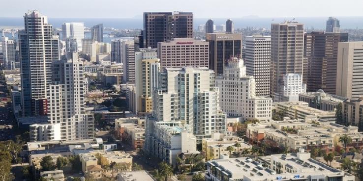
The San Diego region is expected to grow by nearly 1 million people by 2050 and, like San Jose, it has adopted a plan that directs new growth into “urban villages,” mixed-use activity centers connected to transit. At a recent forum, SPUR hosted Bill Anderson and Nancy Bragado from AECOM, who helped create the city’s growth strategy, to share lessons learned with San Jose’s planning staff and the community.
Why Did San Diego Decide to Become a City of Villages?
The San Diego region is richly biodiverse, and concerns over open space and sustainability have defined its approach to planning and growth management. San Diego has a long history of planning for open space preservation and protection, including ballot measures to fund open space purchases and city regulations protecting sensitive environmental resources. In the 1970s and ’80s the city identified areas that were urbanized or were planned to develop, and established a tiered-growth management plan that focused growth in those areas.
San Diego’s most recent general plan, adopted in 2008, established a “City of Villages” strategy to direct future growth into “compact and walkable mixed-use villages of different scales.” Potential urban villages are identified across the city’s 52 community plan areas, and community plans and plan updates provide more detailed land use, density and design direction consistent with the city’s vision for growth.
Bragado and Anderson’s presentation highlighted some key challenges that both San Diego and San Jose face:
Challenge: Both San Jose and San Diego are large cities planning to accommodate a lot of growth. How did San Diego determine how many urban villages it needed and where they should be located?
San Diego identified possible urban villages based on a number of existing characteristics, including where the community has identified the capacity for growth, existing public or planned facilities (like schools and fire stations), existing or planned transit service, community character, and environmental constraints.
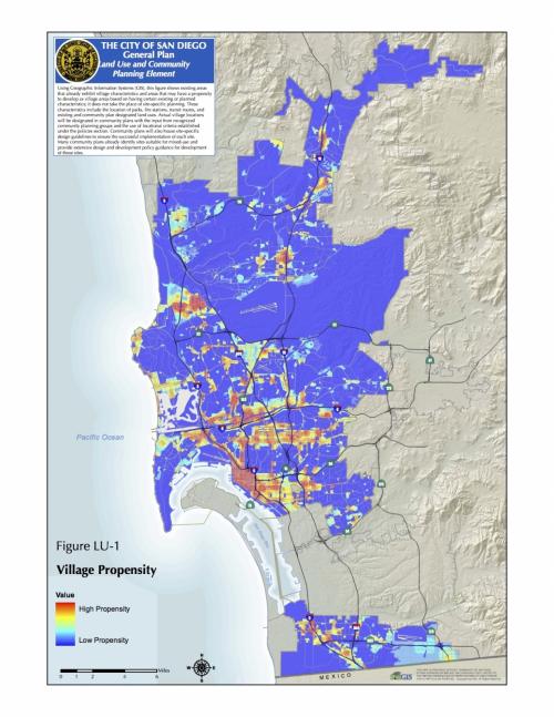 San Diego overlaid the location of parks, fire stations and transit routes onto current land uses to create a map of places that already have important “village characteristics” and could develop as urban villages. Map courtesy City of San Diego.
San Jose, on the other hand, lays out three “horizons” or phases of growth in urban villages. Horizon 1 urban villages are those that are located primarily within central San Jose (about a 3-mile radius around downtown), Horizon 2 urban villages are mostly along light-rail and transit corridors, and Horizon 3 urban villages tend to be those that are on the edges of San Jose (with the exception of the Santana Row/ Valley Fair/ Winchester Urban Village). Development happens first in Horizon 1 and 2.
Challenge: How are these community plans implemented?
In the last three years, nine community plans have been updated, and five are currently in process.
San Diego’s Community Plan Update program plays an essential role in implementing the City of Villages strategy. Through community plan updates, the city is working to meet a range of goals, from increasing the housing supply and jobs in areas with transit access, planning for a multi-modal mobility system, protecting employment lands, planning for parks and public facilities, and streamlining future development that is consistent with the community plan.
This approach addresses neighborhood issues while remaining consistent with the citywide framework set out in the general plan. For example, the general plan sets citywide housing goals, but there is flexibility within each community plan in terms of where and how housing units are distributed and designed. Community plans provide an opportunity to continually adjust how general plan policies are implemented, based on local insight. They also form the basis for capital improvement planning and for deciding impact fees.
Challenge: Both San Jose and San Diego are grappling with a housing shortage and too-high housing costs. How does San Diego make it easier to produce housing?
As it is for San Jose, housing supply and affordability is one of San Diego’s top priorities, and the city has focused a lot of attention on increasing the amount of housing.
The general plan sets out city-wide priorities related to growth, establishes housing targets, and provides standardized land use designations and other tools for implementation, but it does not make any changes to land use or zoning.
That’s where the city’s community plan update program plays a key role in the overall strategy to address housing issues: community plans establish specific land uses and increase housing capacity. Any rezoning that is needed to support new housing density occurs when the plan is adopted. Significantly, in many locations, the zoning allows for ministerial approval, meaning if a project conforms to zoning requirements, it can be approved administratively rather than having to go to a public hearing.
Recently, the Mayor’s Housing Affordability Initiative included a number of approaches to address San Diego’s housing shortage and high housing costs. The city is working to streamline review processes; expand a program to expedite affordable housing, infill projects and sustainable buildings; encourage development of accessory dwelling units; reduce parking requirements; and expand the density bonus and incentives program.
Challenge: How does San Diego ensure that local growth plans are consistent with citywide and regional goals?
Anderson and Bragado said they thought “vertical integration” between regional-level plans, the city’s general plan, community plans and site plans was one of the most important lessons for San Jose. San Diego has established a strong relationship between the general plan and community plans, while integrating with the city’s recent Climate Action Plan, which sets out ambitious transportation and land use goals related to reducing greenhouse gas emissions.
These plans are also developed to fit within the San Diego County Association of Governments (SANDAG) regional planning framework. In fact, the city’s general plan and community plans helped inform the development of San Diego Forward: The Regional Plan, prepared by SANDAG. The Regional Plan combines mobility, environmental and economic planning, and, together with San Diego’s general plan, community planning and City of Villages strategy, lays out a clear, complementary vision for growth in San Diego and throughout the region.
See Anderson and Bragado’s complete presentation >>
Special thanks to Nancy Bragado for reviewing this post.